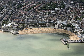
Broadstairs is a coastal town on the Isle of Thanet in the Thanet district of east Kent, England, about 80 miles (130 km) east of London. It is part of the civil parish of Broadstairs and St Peter's, which includes St Peter's, and had a population in 2011 of about 25,000. Situated between Margate and Ramsgate, Broadstairs is one of Thanet's seaside resorts, known as the "jewel in Thanet's crown". The town's coat of arms' Latin motto is Stella Maris. The name derives from a former flight of steps in the chalk cliff, which led from the sands up to the 11th-century shrine of St Mary on the cliff's summit.
"Song of the Mary White" is a ballad written in Broadstairs, England in the early 1850s.

The Shrine of Our Ladye Star of the Sea was an old chapel on the cliffs at Broadstairs. Dating back at least to the 1350s, the two towers of the chapel were a major landmark for sailors in the area. Given the veneration in which the shrine was held, the custom developed of ships dipping their top-sails to salute the shrine as they sailed past it.
The Margate surfboat refers to three surfboats used for maritime rescue at Margate, on the eastern tip of Kent. They were run as cooperatives, with local boatmen clubbing together to buy them and then receiving a share of any salvage money received.

The Northern Belle was an American transatlantic ship which ran aground near Thanet, England, on 5 January 1857. No lives on her were lost, thanks to heroic rescue efforts, in blizzard conditions. However, another ship sank, en route to the scene, the Margate lugger Victory which was lost along with her crew.
The Most Reverend Canon Richard Culmer of Canterbury (1597–1662) was an English Puritan clergyman, iconoclast, and theologian. He is listed by the Oxford Dictionary of National Biography as being of unknown parentage, although some sources indicate that he was the eldest son of Sir Henry Culmer, the first Baron Culmer. According to this family tree, Sir Henry, himself a son of a Henry Culmer, had married Mary Baldwyn of Kent in 1602, and was created a Baron by King Charles I in 1630. Although this is not listed in Burke's Peerage, his family was of considerable importance.

Ramsgate railway station serves the town of Ramsgate in Thanet in Kent, England. The station lies on the Chatham Main Line, 79 miles 21 chains (127.6 km) down the line from London Victoria, the Kent Coast Line, and the Ashford to Ramsgate line. The station is managed by Southeastern, which operates all trains serving it.

Margate railway station serves the town of Margate in Thanet, Kent, England. It is 73 miles 69 chains (118.9 km) down the line from London Victoria. The station and all trains that serve the station are operated by Southeastern.

Broadstairs railway station is on the Chatham Main Line in England, serving the seaside town of Broadstairs, Kent. It is 77 miles 9 chains (124 km) down the line from London Victoria and is situated between Margate and Dumpton Park.

Dumpton Park railway station is on the Chatham Main Line in England, serving the district of Dumpton between the towns of Broadstairs and Ramsgate, Kent. It is 78 miles 26 chains (126.1 km) down the line from London Victoria and is situated between Broadstairs and Ramsgate stations.
North Foreland is a chalk headland on the Kent coast of southeast England, specifically in Broadstairs.
Broadstairs and St Peter's is a civil parish in the Thanet district of Kent, England. The parish comprises the settlements of Broadstairs, St Peter's and Westwood, including Westwood Cross. It is a successor parish, created in 1974 to replace Broadstairs and St Peter's Urban District. It is governed by Broadstairs and St Peter's Town Council. The population in 2001 was 24,370 in 10,594 households.

The Port of Ramsgate is a harbour situated in Ramsgate, south-east England, serving cross-Channel freight traffic and smaller working and pleasure craft. It is owned and operated by Thanet District Council.

Bleak House is a prominent house on the cliff overlooking the North Foreland and Viking Bay in Broadstairs, Kent. It was built around 1801 and then substantially extended, doubling in size, in 1901. The house was the site of the North Cliff Battery and was used as a coastal station for observing maritime activity.

Foreness Point is a low headland on the coast of Kent in England. It extends a short distance into the entrance of the Thames Estuary, on the north coast of Thanet, between Palm Bay in Cliftonville and Botany Bay in Broadstairs. Off the point there is a reef, exposed at low tide, known as Long Nose Spit, where common periwinkles are collected by the public as a food item. There is a water treatment plant on the headland.

St. Stephen's College was an educational establishment for girls run by the Community of St John Baptist, an Anglican convent of Augustinian nuns in Clewer from 1867. The college took gentlemen's daughters, clergymen's daughters, and student teachers.

Whitby Lifeboat Station is a Royal National Lifeboat Institution (RNLI) lifeboat station located in Whitby, North Yorkshire, England. It is one of nine situated along the Yorkshire coast.

Kingsdown Lifeboat Station was located on the shore off Wellington Parade, Kingsdown, a village situated at the north end of the White Cliffs of Dover, Kent.
North Deal Lifeboat Station was located on Beach Street, in the town of Deal, in the county of Kent.

Broadstairs Lifeboat Station was a former lifeboat station in Kent, England. It was rather unusual, as it never had a boathouse, although a building was provided by the Harbour Commissioners in which to store all the equipment. The lifeboat was kept under a tarpaulin, and was stored on the pier at Broadstairs, a harbour town on the east coast of Kent.


