Tenerife is the largest and most populous island of the Canary Islands. It is home to 42.9% of the total population of the archipelago. With a land area of 2,034.38 square kilometres (785.48 sq mi) and a population of 948,815 inhabitants as of January 2023, it is also the most populous island of Spain and of Macaronesia.

A shield volcano is a type of volcano named for its low profile, resembling a shield lying on the ground. It is formed by the eruption of highly fluid lava, which travels farther and forms thinner flows than the more viscous lava erupted from a stratovolcano. Repeated eruptions result in the steady accumulation of broad sheets of lava, building up the shield volcano's distinctive form.

Island arcs are long chains of active volcanoes with intense seismic activity found along convergent tectonic plate boundaries. Most island arcs originate on oceanic crust and have resulted from the descent of the lithosphere into the mantle along the subduction zone. They are the principal way by which continental growth is achieved.

Teide, or Mount Teide, is a volcano on Tenerife in the Canary Islands, Spain. Its summit is the highest point in Spain and the highest point above sea level in the islands of the Atlantic. If measured from the ocean floor, its height of 7,500 m (24,600 ft) makes Teide the third-highest volcano in the world, UNESCO and NASA rank it as Earth's third-tallest volcanic structure. Teide's elevation above sea level makes Tenerife the tenth highest island in the world.
A monogenetic volcanic field is a type of volcanic field consisting of a group of small monogenetic volcanoes, each of which erupts only once, as opposed to polygenetic volcanoes, which erupt repeatedly over a period of time. The small monogenetic volcanoes of these fields are the most common subaerial volcanic landform.

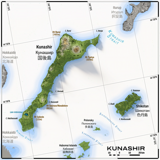
Kunashir Island, possibly meaning Black Island or Grass Island in Ainu, is the southernmost island of the Kuril Archipelago. The island has been under Russian administration since the end of World War II, when Soviet forces took possession of the Kurils. It is claimed by Japan.

The Anahim Volcanic Belt (AVB) is a west–east trending chain of volcanoes and related magmatic features in British Columbia, Canada. It extends from Athlone Island on the Central Coast, running eastward through the strongly uplifted and deeply dissected Coast Mountains to near the community of Nazko on the Interior Plateau. The AVB is delineated as three west-to-east segments that differ in age and structure. A wide variety of igneous rocks with differing compositions occur throughout these segments, comprising landforms such as volcanic cones, volcanic plugs, lava domes, shield volcanoes and intrusions.

The Iceland hotspot is a hotspot which is partly responsible for the high volcanic activity which has formed the Iceland Plateau and the island of Iceland. It contributes to understanding the geological deformation of Iceland.

Tejeda is a village and a municipality in the mountainous central part of the island of Gran Canaria in the province of Las Palmas in the Canary Islands.

Buenavista del Norte is a municipality and town on the north west coast of Tenerife, located on route TF42, about 75 km west of the capital Santa Cruz de Tenerife, 65 km from Tenerife North Airport and 66 km from Tenerife South Airport.

The Central American Volcanic Arc is a chain of volcanoes which extends parallel to the Pacific coastline of the Central American Isthmus, from Mexico to Panama. This volcanic arc, which has a length of 1,100 kilometers (680 mi) is formed by an active subduction zone, with the Cocos plate subducting underneath the Caribbean plate, the North American plate and the Panama plate. Volcanic activity is recorded in the Central American region since the Permian. Numerous volcanoes are spread throughout various Central American countries; many have been active in the geologic past, varying in intensity of their activity according to different factors.
Kostakan is a north-south trending chain of cinder cones located in the southern part of the Kamchatka Peninsula, Russia.

The geology of the Pacific Northwest includes the composition, structure, physical properties and the processes that shape the Pacific Northwest region of North America. The region is part of the Ring of Fire: the subduction of the Pacific and Farallon Plates under the North American Plate is responsible for many of the area's scenic features as well as some of its hazards, such as volcanoes, earthquakes, and landslides.

Tennena Cone, alternatively Icebridge Cone, is a small volcanic cone in Cassiar Land District of northwestern British Columbia, Canada. It has an elevation of 2,390 metres and lies on the western flank of Ice Peak, the prominent south peak of Mount Edziza. The cone is almost completely surrounded by glacial ice of Mount Edziza's ice cap which covers an area of around 70 square kilometres. Tennena Cone is 200 metres high, 1,200 metres long and up to 600 metres wide, its symmetrical structure resembling a black pyramid. The cone and the surrounding area are in Mount Edziza Provincial Park which also includes the Spectrum Range to the south.

The Canadian Cascade Arc, also called the Canadian Cascades, is the Canadian segment of the North American Cascade Volcanic Arc. Located entirely within the Canadian province of British Columbia, it extends from the Cascade Mountains in the south to the Coast Mountains in the north. Specifically, the southern end of the Canadian Cascades begin at the Canada–United States border. However, the specific boundaries of the northern end are not precisely known and the geology in this part of the volcanic arc is poorly understood. It is widely accepted by geologists that the Canadian Cascade Arc extends through the Pacific Ranges of the Coast Mountains. However, others have expressed concern that the volcanic arc possibly extends further north into the Kitimat Ranges, another subdivision of the Coast Mountains, and even as far north as Haida Gwaii.

The 2011–2012 El Hierro eruption occurred just off the island of El Hierro, the second smallest and farthest south and west of the Canary Islands, in the Atlantic Ocean off the coast of Africa. The island is also the youngest in the volcanic chain. The October 2011 – March 2012 eruption was underwater, with a fissure of vents located approximately 2 kilometres to the south of the fishing village of La Restinga on the southern coast of the island. Increased seismicity in June 2012 to the north-west of the vent did not result in another phase of eruptive activity. Until the 2021 La Palma eruption, which started on 19 September 2021, this was the last volcanic eruption in Spain.

The Teno massif is one of three volcanic formations that gave rise to Tenerife, Canary Islands, Spain. It is located in the northwestern part of the island between the towns of Santiago del Teide, Los Silos, El Tanque and Buenavista del Norte. The volcanic massif, emerged during the last 5 to 7 million years, is furrowed by deep ravines and ends abruptly in the sea, in an area known as Los Gigantes, a series of high cliffs that plummet over the sea. The villages known as Masca, Teno Alto, Los Carrizales, El Palmar, Las Portelas and Las Lagunetas preserve the old agricultural traditions of Canary Islands.

Choiyoi Group is a Permian and Triassic-aged group of volcano-sedimentary formations in Argentina and Chile. The group bears evidence of bimodal-style volcanism related to an ancient subduction zone that existed along the western margin of the supercontinent Gondwana.

Atakor volcanic field is a volcanic field in Algeria. It lies in the Hoggar mountains and consists of a variety of volcanic features such as lava flows and about 450 individual vents which create a spectacular scenery.

The geology of the Canary Islands is dominated by volcanoes and volcanic rock. The Canary Islands are a group of volcanic islands in the North Atlantic Ocean, near the coast of Northwest Africa. The main islands are Lanzarote, Fuerteventura, Gran Canaria, Tenerife, La Gomera, La Palma, and El Hierro. There are also some minor islands and islets. The Canary Islands are on the African tectonic plate but they are far from the plate's edges; this controls the type of volcanic activity, known as intraplate volcanism, that has formed the islands.


