Maschsee

Last updated

Masch Lake
Maschsee Hannover.jpg
Masch Lake as seen from the New Town Hall observation platform, about 500 metres (1,600 ft) to its north
Lower Saxony relief location map.jpg
Red pog.svg
Masch Lake
Location Hanover, Lower Saxony
Coordinates 52°21′11″N9°44′41″E / 52.353144°N 9.744674°E / 52.353144; 9.744674 OOjs UI icon edit-ltr-progressive.svg
Type Artificial lake
Native name German: Maschsee
Basin  countriesGermany
Max. lengthc.2.4 km (1.5 mi)
Max. width530 m (1,740 ft)
Surface area0.78 km2 (0.30 sq mi)
Average depthc.2 m (6 ft 7 in)
Water volume1,600,000 m3 (1,300 acre⋅ft) [1]
Surface elevation53.20 m (174.5 ft)
Settlements Hanover

The Masch Lake (German : Maschsee) is an artificial river situated south of the city centre of Hanover, the capital of Lower Saxony, Germany. Spanning an area of 78 hectares (190 acres), it is the largest body of water within Hanover and a popular recreation area as well as venue for numerous water sports.

Contents

Name

The name of the lake stems from the so-called Leinemarsch, or simply Marsch, meaning 'swamp'. This is the historical description for the area in which the lake was built, that was in a deep-lying floodplain of the Leine river.

Construction

Design

Creating a lake in the wide river valley of the Leine river near Hanover was first considered during the late 19th century. This tied in with the by-then necessary dyking of the Leine and Ihme rivers, which would regularly flood the city after snow melted in the Harz mountains in spring. The creation of a lake could reduce the threat of high water levels and put the Leine's river valley area to better use.

Over the course of the following decades different designs emerged, from small to large, such as situating a shooting range (Schützenplatz) on an island within the lake. In September 1925, the newly elected city mayor Arthur Menge commissioned Otto Franzius,  [ de ] a water engineer and professor at the Hanover Technical College (now Leibniz University Hannover), to work out the details of the construction of a lake together with the city's building authorities. Franzius was to be responsible for the designing of the hydro-engineering and hydrological elements of the project, while the city authorities, led by Karl Elkart, would handle the urban development aspects.

In contrast to the original idea that the lake be dug down into swamp land and then be supplied with water from the Leine, a new proposal emerged to build the Maschsee above the swamp in a bowl-like structure raising it higher than the water level of the Leine and having it be filled using a system of water pumps. This would eradicate the potential problem of accumulating mud through flood waters.

Franzius created a final design that proved both effective and financially acceptable, whereupon the city authorities provided a grant of 14,000 Reichsmarks in January 1926 toward attempts to seal the basin of the proposed lake.

Despite the plans being completed it nevertheless took roughly eight years until the beginning of the 1930s for work to commence. The three main factors behind the creation of an artificial lake in the Leine river valley were:

One factor against construction of the lake was the nearly 20-metre-high (66 ft) Bismarck Tower that stood in the centre of the proposed water feature. Here, paramilitary marches took place, and it was the site of a book burning in 1933. The landmark was eventually demolished in 1935 during the course of the lake's construction.

Job creation

In the 1930s, the era of the Great Depression, the city of Hanover lacked the necessary finances to commence the Masch Lake project, even though the project had already been planned at the time for some ten years. The project was favourable for the Nazi Party that came to power in January 1933 as it would help reduce unemployment levels, which was a central theme of their propaganda. On 28 November 1933 the project was approved at a meeting of the city council.

On 21 March 1934 the first ground was broken in the Leine swamp. Despite the unsettled financing of the project, it provided many people with work. Driven by the harshness of the economic situation of the time, they took on tough working conditions and low pay which was barely above unemployment support.

During construction, 14 locomotive trains with 365 tipping wagons were used along a 15-kilometre (9.3 mi) track, as well as diggers and 5 crawler tractors. Many workers though had to supply their own tools. Initially there were 100 people working on the project, but by completion 1,650 people had been involved in the excavation of roughly 780,000 square metres (8,400,000 sq ft) of earth to create the lake basin.

With the Masch Lake project fully completed by early 1936, the official opening took place on 21 May 1936. Hundreds of thousands of Hanoverians and guests looked on from the edge of the lake as the event began with the then-typical trooping of the Nazi Party. In addition some 6,000 sporting persons took part in a rally along with the armed forces and public officials.

Just a few years later, during World War II, the lake was covered up with canvasses and fake landscapes created on floating islands in an attempt to confuse Allied bomber pilots regarding their whereabouts during air raids on Hanover.

Water supply

The water level loses a maximum of 1.3 centimetres (0.51 in) per day through evaporation and water seepage, which equates to 10,000 cubic metres (350,000 cu ft) of water. In order to maintain a constant level, a pump station at a series of ponds in Ricklingen provides the Masch Lake with a water supply. Its three pumps send water along an 800-metre-long (2,600 ft) pipe to the "source" of the Masch Lake. Depending on weather conditions, between 1–2 million cubic metres (35–71 million cubic feet) of water are required per year. From November until February no pumping is carried out, so the water level sinks on average 45 centimetres (18 in) during this time.

The "source" of the Masch Lake, with empty water basin Maschsee Maschseequelle Becken leer.jpg
The "source" of the Masch Lake, with empty water basin

Until 1960, the water level of the Masch Lake was supplied by the Masch Lake Source pump station. Its pumping and filtering houses were one of the first building projects at the site of the lake to be put into operation in November 1935. The plant is equipped with two pumps which are capable of raising 500 litres (130 US gal) of water every second from the Leine.

As the Leine is strongly contaminated with suspended sediment, the usage of this water supply meant that the Masch Lake quickly began to silt up. In 1960, the Hanover city administration therefore decided to build a new pump station at the Ricklingen Ponds, in order to supply the lake with groundwater.

The old pumping house is only used today when the oxygen content of the water is too low, as this water is supplied to the lake through an open-air three-stage cascading system that raises oxygen levels. It is also put into use during the Masch Lake Festival.  [ de ]

Today the old pumping house is used as a club house by the Hanover Sport Club.

Leisure activities

The annual Masch Lake Festival. Maschseefest Nordufer.jpg
The annual Masch Lake Festival.

Masch Lake Festival

In summer the Masch Lake Festival (Maschseefest) is held over several weeks beside the lake, which draws around two million visitors annually. The event was first staged in 1986 to commemorate the 50th anniversary of the lake's opening. It features musical performances, cabaret, cuisine and firework displays.

A boat operated by ustra during the festival. Maschseeboot Ustralala.jpg
A boat operated by üstra during the festival.

Boats and ships

During the summer months the Hanoverian transport company üstra operates boat trips on the lake using electrically powered vessels. Surrounding the Masch Lake are numerous clubs for water sports (most popularly, rowing and sailing). During the year many diverse competitions are held on the lake, including the annual European Dragon Boat Race.

Between 1952 and 1989 motor boat competitions were regularly staged on the lake, which saw four world championships contested and ten European champions crowned.

Bathing

The Masch Lake Beach lies at the southern point of the lake. In 2005, the city handed over the former city open air pool to a private investor who began construction on a commercial wellness park that stalled before being taken over by investor group Aspria in 2007.

In spring 2009 Aspria Hannover opened a private spa and sport club in the buildings of the old public facilities and some newly built premises. Aspria also took over the running of the public bathing area, although since 2009 over half of the bathing area has been accessible to members of the private Aspria club only.

Exercising

With its proximity to the centre of Hanover, the Masch Lake is a popular recreation area for the city's walkers and joggers. In 2005, a 6-kilometre-long (3.7 mi) route around the lake was mapped out by the German Athletics Association. This track runs along the footpath, closer to the water than the asphalt-coated cycle path. Since 2003 the cycle path has also been open for roller skating usage.

Ice activities

Ice hockey on the frozen Masch Lake. Maschseeeis Panorama.jpg
Ice hockey on the frozen Masch Lake.

If the lake freezes in winter and the thickness of the ice exceeds 13 centimetres (5.1 in), the city authorities hoist a flag at the northern shore of the lake to indicate that it is permitted to go onto the ice. In periods of constant cold weather the lake can draw more than 10,000 visitors a day for activities such as ice skating and ice hockey. When ice thickness reaches 20 centimetres (7.9 in), as it did in 2003, stalls may also be erected on the ice.

Art works

Notable works of art on the northern side of the lake are the 6-metre-high (20 ft) red steel "Hellebardier" (meaning 'Halberdier') sculpture by Alexander Calder (1972) as well as the bronze Olympic torchbearer that stands atop an 18.5-metre-high (61 ft) stone column and "Putto on the Fish" that were both created in 1936 by Hermann Scheuernstuhl  [ de ].

Other sculptures on the eastern side are the "Menschenpaar" (meaning 'Human Couple') by Georg Kolbe (1936–37) and two lion sculptures created by Arno Breker (1938). In 1948 Erich Haberland  [ de ] unveiled his piece "The Swimmer", which stands in the public bathing area.

Spanish artist Santiago Sierra caused a sensation in 2005 when he remembered the fact that the Masch Lake was built through a Nazi work programme by installing a walk-in room filled with mud at the Kestner Society Art Gallery.

A light art project was held around the lake at the start of 2009 under the title "New Moon on the Lake". The display consisted of 22 illuminated pieces that had been created by international artists, which formed the opening of the 2009 Garden Project in Hanover.

Accessibility

Hanover's New Town Hall lies close to the Masch Lake. Hannover Maschsee Neues Rathaus 2007 by-RaBoe.jpg
Hanover's New Town Hall lies close to the Masch Lake.

The Masch Lake lies close to other notable places, such as the New Town Hall, the Lower Saxon State Museum Hanover, the Sprengel Museum, the Lower Saxon Stadium (home of the football club Hannover 96), the main city indoor swimming pool as well as the Lower Saxon broadcasting houses of television channels NDR and ZDF.

The lake is directly accessible by using the bus stops at the Lower Saxon Stadium and the Sprengel Museum. Additional bus and tram stops such as the Aegidientorplatz, Schlägerstraße, Geibelstraße, Altenbekener Damm and Döhren Tower also lie in relatively close proximity to the lake.

Numerous foot and cycle paths lead to the Masch Lake and follow along its shoreline. The western side of the lake, where the club houses of numerous water sport clubs are situated, is only accessible by foot or cycle as vehicles are not permitted without official permission.

General references

Related Research Articles

<span class="mw-page-title-main">Hanover, New Hampshire</span> Town in New Hampshire, United States

Hanover is a town located along the Connecticut River in Grafton County, New Hampshire, United States. As of the 2020 census, its population was 11,870. The town is home to the Ivy League university Dartmouth College, the U.S. Army Corps of Engineers Cold Regions Research and Engineering Laboratory, and Hanover High School. The Appalachian Trail crosses the town, connecting with a number of trails and nature preserves.

<span class="mw-page-title-main">Hanover</span> Capital of Lower Saxony, Germany

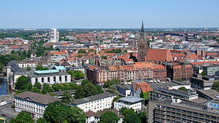
Hanover is the capital and largest city of the German state of Lower Saxony. Its 535,932 (2021) inhabitants make it the 13th-largest city in Germany as well as the fourth-largest city in Northern Germany after Berlin, Hamburg and Bremen. Hanover's urban area comprises the towns of Garbsen, Langenhagen and Laatzen and has a population of about 791,000 (2018). The Hanover Region has approximately 1.16 million inhabitants (2019).

<span class="mw-page-title-main">Lower Saxony</span> State in Germany

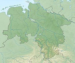
Lower Saxony is a German state in northwestern Germany. It is the second-largest state by land area, with 47,614 km2 (18,384 sq mi), and fourth-largest in population among the 16 Länder federated as the Federal Republic of Germany. In rural areas, Northern Low Saxon and Saterland Frisian are still spoken, albeit in declining numbers.

<span class="mw-page-title-main">Aller (Germany)</span> River in Germany

The Aller is a 215-kilometre-long (134 mi) river in the states of Saxony-Anhalt and Lower Saxony in Germany. It is a right-hand, and hence eastern, tributary of the Weser and is also its largest tributary. Its last 117 kilometres (73 mi) form the Lower Aller federal waterway. The Aller was extensively straightened, widened and, in places, dyked, during the 1960s to provide flood control of the river. In a 20-kilometre-long (12 mi) section near Gifhorn, the river meanders in its natural river bed.

Hanover Region is a district in Lower Saxony, Germany. It is bounded by the districts of Heidekreis, Celle, Gifhorn, Peine, Hildesheim, Hamelin-Pyrmont, Schaumburg and Nienburg.

<span class="mw-page-title-main">Sprengel Museum</span> Art museum in Lower Saxony, Germany

Sprengel Museum is a museum of modern art in Hanover, Lower Saxony, holding one of the most significant collections of modern art in Germany. It is located in a building situated adjacent to the Masch Lake approximately 150 metres (490 ft) south of the state museum. The museum opened in 1979, and the building, designed by Peter and Ursula Trint and Dieter Quast, was extended in 1992.

<span class="mw-page-title-main">Waranga Dam</span> Dam in North Central region, Victoria

The Waranga Dam is a major earthfill embankment dam with an uncontrolled spillway located approximately 150 kilometres (93 mi) north of Melbourne in the North Central region of the Australian state of Victoria. The impounded off-stream reservoir is Waranga Basin and forms part of the Goulburn River irrigation system, irrigating an area of 626 square kilometres (242 sq mi). The dam and reservoir are located in Shire of Campaspe near the City of Greater Shepparton and is located 8 kilometres (5 mi) north-east of Rushworth, 12 kilometres (7.5 mi) south-west of Tatura, and near Murchison. When full, the reservoir covers an area of 58.5 square kilometres (22.6 sq mi).

<span class="mw-page-title-main">Duchy of Brunswick</span> German duchy (1815–1918)

The Duchy of Brunswick was a historical German state. Its capital was the city of Brunswick . It was established as the successor state of the Principality of Brunswick-Wolfenbüttel by the Congress of Vienna in 1815. In the course of the 19th-century history of Germany, the duchy was part of the German Confederation, the North German Confederation and from 1871 the German Empire. It was disestablished after the end of World War I, its territory incorporated into the Weimar Republic as the Free State of Brunswick.

<span class="mw-page-title-main">Garbsen</span> Town in Lower Saxony, Germany

Garbsen is a town in the district of Hanover, in Lower Saxony, Germany. It is situated on the river Leine, approx. 11 km northwest of Hanover. The name Garbsen can be traced back to 1223. Today's 13 city districts have partly developed independently until the city of Garbsen was formed within its current boundaries during the regional reform in 1974.

<span class="mw-page-title-main">Wivenhoe Dam</span> Dam in South East Queensland

The Wivenhoe Dam is a rock and earth-fill embankment dam with a concrete spillway across the Brisbane River in South East Queensland, Australia. The dam takes it names from the local Wivenhoe Pocket rural community. The dam wall is located about 80 kilometres (50 mi) by road from the centre of Brisbane. The primary purpose of the dam is the supply of potable water for the Brisbane and Ipswich regions. The dam also provides for flood mitigation control, hydroelectricity, and recreation. The impounded reservoir is called Lake Wivenhoe and the dam, the lake and a narrow strip of surrounding land forms a locality also called Lake Wivenhoe.

<span class="mw-page-title-main">Hannover Hauptbahnhof</span> Main railway station of Hanover, Germany

Hannover Hauptbahnhof is the main railway station for the city of Hanover in Lower Saxony, Germany. The railway junction is one of the 21 stations listed as a railway Category 1 station by DB Station&Service. It is also the most important public transport hub of the region of Hanover and it is served regional and S-Bahn services. The station has six platforms with twelve platform tracks, and two through tracks without platforms. Every day it is used by 250,000 passengers and 622 trains stop at the platforms. About 2,000 people work here.

<span class="mw-page-title-main">Kestnergesellschaft</span>

Kestner Gesellschaft is an art institution in Hanover, Germany, founded in 1916 to promote the arts. Its founders included the painter Wilhelm von Debschitz (1871–1948). The association blossomed under the management of Alexander Dorner and Justus Bier, pioneering modern art.

<span class="mw-page-title-main">Weißer See (Berlin)</span>

Weißer See is a lake in the Weissensee district of Berlin, Germany. Its surface area is 8.3011ha (84,000m2) and volume 360,606m3. With a depth of 10.64m it is one of the deepest areas of water in Berlin. Its dimensions are approx. 300m East-West by 350m North-South.

<span class="mw-page-title-main">Hanoverian Moor Geest</span>

The Hanoverian Moor Geest is a gently rolling landscape between Hanover and Nienburg in the German state of Lower Saxony covering an area of around 800 square kilometres (310 sq mi). It belongs to the raised bog regions of northwest Germany, which cover the geest terrain formed during the ice age and which stretch from the Netherlands to the eastern border of Lower Saxony. The geest tract on the Hanoverian Moor Geest consists of a ground moraine plateau with a height of 50–85 metres (164–279 ft) above sea level that is dominated by bog. Its natural boundaries are the Aller glacial valley to the north and the Burgdorf-Peine Geest to the east.

<span class="mw-page-title-main">Calenberg</span> Hill in central Germany in the Leine depression near Pattensen in the municipality of Schulenburg

The Calenberg is a hill in central Germany in the Leine depression near Pattensen in the municipality of Schulenburg. It lies 13 km west of the city of Hildesheim in south Lower Saxony on the edge of the Central Uplands. It is made from a chalk marl slab (Kalkmergelbank), has a height of 70 m above NN and was formed almost 100 million years ago at the beginning of the Upper Cretaceous series in Cenomanian stage. The Calenberg became historically important as a result of the fort, stronghold and castle built as the main residence of the House of Hanover.

<span class="mw-page-title-main">Roter Faden</span> Urban walking trail in Hanover, Lower Saxony

The Red Thread is a 4.2-kilometre (2.6 mi) urban walking trail in Hanover, Germany, to 36 significant points of interest about architecture and the history of the city centre.

<span class="mw-page-title-main">Hanover-Mitte</span> Borough of Hanover in Lower Saxony, Germany

Mitte is the first borough of Hanover, the state capital of Lower Saxony. As of 2020, it has 36,645 inhabitants and consists of the quarters Mitte, Calenberger Neustadt, Oststadt and Zoo. The district mayor is Cornelia Kupsch (CDU).

<span class="mw-page-title-main">Bismarck Tower (Hanover)</span>

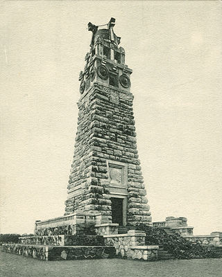
The Bismarck Tower in Hanover, Germany was a tower erected as a monument to the first Chancellor of the united German nation Otto von Bismarck for patriotic and nationalistic purposes, which then became a hub for national socialist events in the city until its dismantlement in 1935 as part of the building of the Maschsee.

Sülbeck is one of the oldest villages in the town of Einbeck, district Northeim. The development of the village is connected to the saline springs. These were used to produce brine and salt for some hundred years.

The Saw-Killer of Hanover is the name of an unidentified German serial killer, who is supposedly responsible for murdering and dismembering at least four women and two men, whose body parts were found in Hanover and the surrounding area in the 1970s. None of the victims have been identified, and the case is also referred to as The Found Corpses of Hanover. The "SOKO Torso" Unit of the Hanoverian police, directed by Commissioner Günter Nowatius, investigated the murders at the time.

References

  1. "Maschsee Leitfaden Maßnahmenplanung" [Maschsee Action planning guide](PDF) (in German). Lower Saxony State Office for Water management, coastal and nature protection. Retrieved 25 February 2022.