Interstate 93 (I-93) is an Interstate Highway in the New England region of the United States. It begins in Canton, Massachusetts, in the Boston metropolitan area, at I-95; and ends near St. Johnsbury, Vermont, at I-91. It is one of three mainline Interstate highways located wholly within New England, the other two being I-89 and I-91. The largest cities along its route are Manchester, New Hampshire, and Boston, Massachusetts. It also passes through the New Hampshire state capital of Concord.
Interstate 89 (I-89) is an Interstate Highway in the New England region of the United States traveling from Bow, New Hampshire, to the Canadian border between Highgate Springs, Vermont, and Saint-Armand, Quebec. As with all odd-numbered primary interstates, I-89 is signed as a north–south highway. However, it follows a primarily northwest-to-southeast path. The route forms a substantial part of the main connection between the cities of Montreal and Boston. In Quebec the route continues as Quebec Route 133. The eventual completion of Autoroute 35 from Montreal will lead to a non-stop limited access highway route between the two cities, following I-93 south from I-89's terminus. The largest cities directly served by I-89 are Concord, the state capital of New Hampshire, Montpelier, the state capital of Vermont, and Burlington, Vermont. I-89 is one of three main Interstate highways whose route is located entirely within New England, along with I-91 and I-93.
North Hampton is a town in Rockingham County, New Hampshire, United States. The population was 4,301 at the 2010 census. While the majority of the town is inland, North Hampton includes a part of New Hampshire's limited Atlantic seacoast.
U.S. Route 202 (US 202) is a spur route of U.S. Route 2. It follows a northeasterly and southwesterly direction stretching from Delaware to Maine, also traveling through the states of Pennsylvania, New Jersey, New York, Connecticut, Massachusetts, and New Hampshire. The highway has borne the number 202 since at least 1936. Before this, sections of the highway were designated U.S. Route 122, as it intersected US 22. Its current designation is based on its intersection with US 2 in Maine.

U.S. Route 3 (US 3) is a United States highway running 277.9 miles (447.2 km) from Boston, Massachusetts, through New Hampshire, to the Canada–US border near Third Connecticut Lake, where it connects to Quebec Route 257.
Interstate 86 (I-86) is an east–west intrastate Interstate Highway located entirely within the state of Idaho. It runs approximately 63 miles (101 km) from an intersection with I-84 east of Declo in rural Cassia County, to an intersection with I-15 in Chubbuck, just north of Pocatello. The highway is part of the main route from Boise and Twin Falls to Idaho Falls and the upper Snake River region.
The Spaulding Turnpike is a 33.2-mile (53.4 km) north-south toll road in eastern New Hampshire. Nearly its entire length is overlapped by New Hampshire Route 16. Its southern terminus is at the Portsmouth Traffic Circle in Portsmouth, a terminus it shares with U.S. Route 4 and NH 16. Its northern terminus is at an interchange with New Hampshire Route 125 in Milton, where NH 16 continues north as a full-access highway.

New Hampshire Route 101 is a state-maintained highway in southern New Hampshire extending from Keene to Hampton Beach. It is the major east–west highway in the southern portion of the state.

New Hampshire Route 33 is an 9.090-mile-long (14.629 km) east–west highway in the Seacoast Region of southeastern New Hampshire, connecting Stratham with Portsmouth. The western terminus is at New Hampshire Route 108 in Stratham. The eastern terminus is at U.S. Route 1 in downtown Portsmouth. It is a former routing of New Hampshire Route 101.

New Hampshire Route 112 is a 56.39-mile-long (90.75 km) east–west state highway in northern New Hampshire. The highway winds across the state, connecting Bath to Conway through the heart of the scenic and mountainous White Mountain National Forest.

New Hampshire Route 125 is a 51.994-mile-long (83.676 km) north–south state highway in Rockingham, Strafford and Carroll counties in southeastern New Hampshire. The southern terminus is in Plaistow at the Massachusetts state line, where the road continues south into Haverhill as Massachusetts Route 125. The northern terminus is in Wakefield at New Hampshire Route 16 and New Hampshire Route 153.
The New Hampshire Highway System is the public roads system of the U.S. state of New Hampshire containing approximately 17,029 miles (27,406 km) maintained by the New Hampshire Department of Transportation (NHDOT). All public roads in the state are called "highways", thus there is no technical distinction between a "road" or a "highway" in New Hampshire.
Interstate 95 (I-95) is a part of the Interstate Highway System that parallels the East Coast of the United States from Houlton, Maine in the north to Miami, Florida in the south. In the U.S. state of Massachusetts, it spans 91 miles (146 km) along a north–south axis. It is the third-longest Interstate Highway in Massachusetts, behind I-90 and I-495, while I-95 in full is the longest north–south interstate, and sixth-longest Interstate Highway in the United States.
Interstate 75 (I-75) is a part of the Interstate Highway System that runs north–south from Miami, Florida, to Sault Ste. Marie in the Upper Peninsula of the US state of Michigan. I-75 enters the state from Ohio in the south, north of Toledo, and runs generally northward through Detroit, Pontiac and Bay City, crosses the Mackinac Bridge, and ends at the Canadian border in Sault Ste. Marie. The freeway runs for approximately 396 miles (637 km) on both of Michigan's major peninsulas. The landscapes traversed by I-75 include Southern Michigan farmland, northern forests, suburban bedroom communities, and the urban core of Detroit. The freeway also uses three of the state's monumental bridges to cross major bodies of water. There are four auxiliary Interstates in the state related to I-75, as well as nine current or former business routes, with either Business Loop I-75 or Business Spur I-75 designations.
Route 286 is a 3.7-mile-long (6.0 km) east–west state highway in Salisbury, Massachusetts and Seabrook, New Hampshire. The route was previously known as Route 86 and was renumbered to avoid a numerical conflict with the designation of a freeway as Interstate 86 in the 1970s. Route 286 is the highest numbered New Hampshire state highway.
In the U.S. state of New Hampshire, U.S. Route 1 is a north–south state highway through Hampton and Portsmouth. It lies between Interstate 95 and New Hampshire Route 1A.

In the U.S. state of Massachusetts, U.S. Route 1 is a major north–south highway through Boston. The portion of US 1 south of Boston is also known as the Boston-Providence Turnpike, Washington Street, or the Norfolk and Bristol Turnpike, and portions north of the city are known as the Northeast Expressway and the Newburyport Turnpike.

Salem station is an MBTA Commuter Rail station served by the Newburyport/Rockport Line. The station is located off Bridge Street near its interchange with North Street at the north end of downtown Salem, Massachusetts. The station has a single accessible full-length high-level platform serving the single track of the Eastern Route. Just south of the station is the Salem Tunnel, which carries the line under Washington Street. Salem is a major park and ride center, with a 700-space parking garage, as well as an MBTA Bus terminal. It is the busiest commuter rail station in the MBTA system outside of the central Boston stations, with an average of 2,326 daily boardings in a 2018 count.
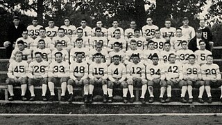
The 1934 New Hampshire Wildcats football team was an American football team that represented the University of New Hampshire as a member of the New England Conference during the 1934 college football season. In its 19th season under head coach William "Butch" Cowell, the team played its home games in Durham, New Hampshire, at Memorial Field. The team compiled a 3–4–2 record, being outscored by their opponents 89–148, while going undefeated at home, registering two wins and two ties in Durham.
