
The London Borough of Islington is a London borough which forms part of Inner London, England. Islington has an estimated population of 215,667. It was formed in 1965, under the London Government Act 1963, by the amalgamation of the metropolitan boroughs of Islington and Finsbury.
Tadley is a town and civil parish in the Basingstoke and Deane district of Hampshire, England, 5.5 miles (8.9 km) north of Basingstoke and 11 miles (17 km) south west of Reading.
Eastleigh is a town in Hampshire, England, between Southampton and Winchester. It is the largest town and the administrative seat of the Borough of Eastleigh, with a population of 24,011 at the 2011 census.

Farringdon is an interchange station located in Clerkenwell, London, England, in the London Borough of Islington, just outside the boundary of the City of London for London Underground, Elizabeth line and National Rail services.

Dinton is a village in Buckinghamshire, England, within the Buckinghamshire Council unitary authority area. It is in the south of the Aylesbury Vale on the ancient turnpike leading from Aylesbury to Thame. It is within the civil parish of Dinton with Ford and Upton. The village name is Anglo Saxon in origin, and means 'Dunna's estate'. In the Domesday Book of 1086 it was listed as Danitone.

Tidworth is a garrison town and civil parish in south-east Wiltshire, England, on the eastern edge of Salisbury Plain. Lying on both sides of the A338 about 3+1⁄2 miles (5.6 km) north of the A303 primary route, the town is approximately 8 miles (13 km) west of Andover, 12 miles (19 km) south of Marlborough, and 13 miles (21 km) north by north-east of Salisbury. The population of the parish at the 2011 census was approximately 10,600.

Bramhall is a large village in the Metropolitan Borough of Stockport, Greater Manchester, England. In 2011 it had a population of 17,436.

Alton is a civil parish in Wiltshire, England. The parish includes the adjacent villages of Alton Barnes and Alton Priors, and the nearby hamlet of Honeystreet on the Kennet and Avon Canal. It lies in the Vale of Pewsey about 6 miles (10 km) east of Devizes.

Toddington is a large village and civil parish in the county of Bedfordshire, England. It is situated 5 miles north-north-west of Luton, 4 miles (6 km) north of Dunstable, 6 miles (10 km) south-west of Woburn, and 35 miles north-north-west of London on the B5120 and B579. It is 0.5 miles from Junction 12 of the M1 motorway and lends its name to the nearby motorway service station. The hamlet of Fancott also forms part of the Toddington civil parish.

Whitefield's sometimes Whitfield's Tabernacle is a former Calvinistic Methodist and Congregational church in Kingswood, a town on the eastern edge of Bristol where George Whitefield preached in the open air to coal miners. The name refers to two buildings in which the congregation met.

Dunham Massey is a civil parish in the Metropolitan Borough of Trafford, Greater Manchester, England. The parish includes the villages of Sinderland Green, Dunham Woodhouses and Dunham Town, along with Dunham Massey Hall and Park, formerly the home of the last Earl of Stamford and owned by the National Trust since 1976. Dunham Massey is in the historic county of Cheshire, but since 1974 has been part of Trafford Metropolitan Borough; the nearest town is Altrincham. At the 2001 census, the parish had a population of 475.

A tin tabernacle, also known as an iron church, is a type of prefabricated ecclesiastical building made from corrugated galvanised iron. They were developed in the mid-19th century, initially in the United Kingdom. Corrugated iron was first used for roofing in London in 1829 by civil engineer Henry Robinson Palmer, and the patent was later sold to Richard Walker who advertised "portable buildings for export" in 1832. The technology for producing the corrugated sheets improved and, to prevent corrosion, the sheets were galvanised with a coating of zinc, a process developed by Stanislas Sorel in Paris in the 1830s. After 1850, many types of prefabricated buildings were produced, including churches, chapels and mission halls.

Sway is a village and civil parish in Hampshire in the New Forest national park in England. The civil parish was formed in 1879, when lands were taken from the extensive parish of Boldre. The village has shops and pubs, and a railway station on the South West Main Line from Weymouth and Bournemouth to Southampton and London Waterloo. It is the site of Sway Tower, a 66-metre (217 ft) concrete folly built in the 19th century. The outbuildings of the Grade II listed Forest Heath House are used as artist studios and exhibition space by the charity SPUDWorks.
Bohunt School is a coeducational secondary school and sixth form located in the rural village of Liphook, Hampshire, England. The school was opened in 1978.

Farringdon is a civil parish in the East Hampshire district of Hampshire, England. It is 2.8 miles (4.5 km) south of Alton, on the A32 road, close to a source of the River Wey.

Medstead is a village and civil parish in the East Hampshire district of Hampshire, England. Its nearest town is Alton, which lies 4.3 miles (6.9 km) northeast of the village. According to the 2011 census, the village had a population of 2,036 people. The parish covers an area of 1,536 acres (622 ha) and has an average elevation of approximately 600 feet (180 m) above sea level. One of the county's high points at 716 feet (218 m), King's Hill, runs through Medstead and Bentworth.

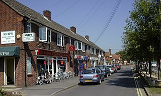
Headley Down is a village within the civil parish of Headley in the East Hampshire district of Hampshire, England, bounded on two sides by Ludshott Common, a National Trust heathland reserve. The village began with a few buildings in the 1870s and became a thriving community that in the 20th century outgrew the parish centre of Headley.

Darland's Lake Nature Reserve is a nature reserve south of Totteridge Village in Barnet, England. It is owned by the London Borough of Barnet and was managed from 1971 by the Hertfordshire and Middlesex Wildlife Trust, and more recently by the borough council. In 2007 the council spent £215,000 on repairing the dam and other works, and then proposed leasing the reserve to the Wildlife Trust. The transfer did not take place and in September 2017 a trust was set up by the London Wildlife Trust and local residents associations which took over the management of Darland's Lake. In 2020, the Darlands Conservation Trust launched an appeal to raise £450,000 for excavation to prevent the lake drying up.

The Congregational Memorial Hall in Farringdon Street, London was built to commemorate the 200th anniversary of Great Ejection of Black Bartholomew's Day, resulting from the 1662 Act of Uniformity which restored the Anglican church. The two thousand puritan ministers who refused to take the oath of conformity thereby established non-conformism.
