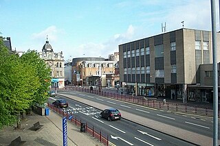
Hamilton is a large town in South Lanarkshire, Scotland. It serves as the main administrative centre of the South Lanarkshire council area. It sits 10 miles (16 km) south-east of Glasgow, 37 miles (60 km) south-west of Edinburgh and 74 miles (120 km) north of Carlisle. It is situated on the south bank of the River Clyde at its confluence with the Avon Water. Hamilton is the county town of the historic county of Lanarkshire and is the location of the headquarters of the modern local authority of South Lanarkshire.

South Lanarkshire is one of 32 unitary authorities of Scotland. It borders the south-east of the Glasgow City council area and contains some of Greater Glasgow's suburban towns, as well as many rural towns and villages. It also shares borders with Dumfries and Galloway, East Ayrshire, East Renfrewshire, North Lanarkshire, the Scottish Borders and West Lothian. It includes most of the historic county of Lanarkshire.

Lanarkshire, also called the County of Lanark, is a historic county, lieutenancy area and registration county in the Central Lowlands and Southern Uplands of Scotland. The county is no longer used for local government purposes, but gives its name to the two modern council areas of North Lanarkshire and South Lanarkshire.

Crawford Castle, substantially in ruins, is located on the north bank of the River Clyde, around 1⁄2 mile north of Crawford, South Lanarkshire, Scotland. The ruins stand on an earlier motte and bailey earthwork. The castle is also known as Lindsay Tower, after its former owners, the Lindsay family. The strategic location of the castle, at NS954213, guards the strategically important Mennock Pass from England into the upper Clyde Valley.

Dalserf is a small village of only a few streets in South Lanarkshire, Scotland. It lies on the River Clyde, 2 miles (3 km) east of Larkhall and 7 miles (11 km) south east of Hamilton.
Douglas Castle was a stronghold of the Douglas family from medieval times to the 20th century. The first castle, erected in the 13th century, was destroyed and replaced several times until the 18th century when a large mansion house was built in its place. This too was demolished in 1938, and today only a single corner tower of the 17th-century castle remains. The castle was the former family seat of the Prime Minister, Sir Alec Douglas-Home. The castle was located around 1 kilometre (0.62 mi) north-east of the village of Douglas, South Lanarkshire, in south-west Scotland. The remains are protected as a category C listed building.

Victoria Bridge is the early 20th century lattice girder bridge over the River Dee at Mar Lodge on Mar Lodge Estate, Aberdeenshire, Scotland. This bridge, built in 1905 and replaced an earlier wooden bridge, built in 1848 by the Duke of Leeds during his tenancy of the estate. The archway at the south end of the bridge bears '1848 Queen Victoria 1848' on the south side and '1905 Edward VII 1905' commemorating the construction of both bridges and the reigning monarch at the time.

Rosebank is a small hamlet situated in South Lanarkshire, Scotland. With a population of around 200, Rosebank is one of the least-populated settlements in South Lanarkshire. The hamlet is situated on the banks of the River Clyde, and was constructed by Lord Newlands of Mauldslie Castle for estate workers.

The Clyde Valley Woodlands National Nature Reserve (NNR) comprises six separate woodland sites in the Clyde Valley region of South Lanarkshire, Scotland. These six sites are located along a 12 km section of the River Clyde and its tributaries, and lie close to built-up areas such as Hamilton and Lanark on the southern outskirts of Greater Glasgow. The sites can be easily accessed by about two million people living in the surrounding urban areas, making the reserve unique amongst Scotland's NNRs, most of which tend to be located in more remote areas. The six sites are:

The Lanark Hydro Electric Scheme consists of two hydroelectric plants in the Clydesdale area of South Lanarkshire, Scotland. They are run-of-the-river power stations, using water from the River Clyde near to the Falls of Clyde. Bonnington Power Station gets its water supply from just above Corra Linn in New Lanark, while Stonebyres Power Station takes water from above Stonebyres Linn near Kirkfieldbank. Bonnington is the larger of the two stations, which between them can produce 17 MW.
Libberton is a village and historical parish in South Lanarkshire. The village is approximately 2 miles (3.2 km) north of Quothquan and 2.3 miles (3.68 km) south-east of Carnwath. The nearest rivers are the South Medwyn River, the North Medwyn River and the River Clyde which lies the east of the village.

Mauldslie Castle West Lodge is a 19th-century gatehouse in Dalserf, South Lanarkshire, Scotland. A Category A listed building, it was completed in 1861, believed to be the work of David Bryce.

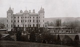
Mauldslie Castle, part of the Mauldslie Estate, was located in Dalserf, South Lanarkshire, Scotland.


