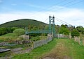
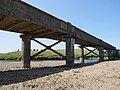
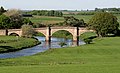
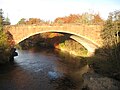
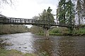
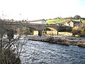
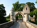
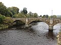
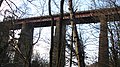
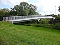
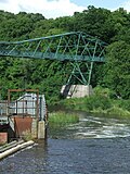
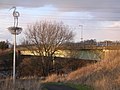
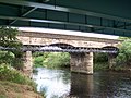
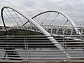
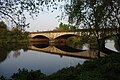
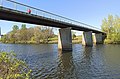
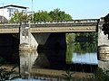
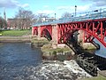
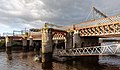
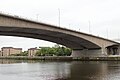
Crossing Date Coordinates Heritage Locality Notes Photo Railway Bridge 55°26′02″N 3°38′54″W / 55.434°N 3.6483°W / 55.434; -3.6483 (Elvanfoot Railway Bridge ) - Elvanfoot West Coast Main Line Elvanfoot Suspension Bridge [ 2] 1900 55°26′28″N 3°39′18″W / 55.4411°N 3.6549°W / 55.4411; -3.6549 (Elvanfoot Suspension Bridge ) B Elvanfoot Motorway Bridge 55°26′48″N 3°39′08″W / 55.4467°N 3.6521°W / 55.4467; -3.6521 (Elvanfoot Motorway Bridge ) - Elvanfoot A74(M) Elvanfoot Bridge 55°26′50″N 3°39′01″W / 55.4472°N 3.6503°W / 55.4472; -3.6503 (Elvanfoot Bridge ) - Elvanfoot B7076 Crawford Footbridge 55°28′17″N 3°39′09″W / 55.4713°N 3.6525°W / 55.4713; -3.6525 (Crawford Footbridge ) - Crawford Camps Road Bridge 55°28′25″N 3°39′33″W / 55.4736°N 3.6591°W / 55.4736; -3.6591 (Camps Road Bridge ) - Crawford Railway Bridge 55°28′23″N 3°39′54″W / 55.4731°N 3.6649°W / 55.4731; -3.6649 (Crawford Railway Bridge ) - Crawford West Coast Main Line Southwood Farm Access Bridge 55°29′32″N 3°41′21″W / 55.4923°N 3.6891°W / 55.4923; -3.6891 (Southwood Farm Bridge ) - Abington Clyde's Bridge Early 19th Cent 55°31′21″N 3°40′43″W / 55.5225°N 3.6786°W / 55.5225; -3.6786 (Clyde's Bridge ) B Lamington Wandel Road Bridge 55°31′22″N 3°40′43″W / 55.5227°N 3.6787°W / 55.5227; -3.6787 (Wandel Road Bridge ) - Lamington A702 Railway Bridge 55°33′15″N 3°38′06″W / 55.5541°N 3.6351°W / 55.5541; -3.6351 (Lamington Railway Bridge ) - Lamington West Coast Main Line Lamington Bridge [ 3] 1836 55°33′19″N 3°37′57″W / 55.5552°N 3.6325°W / 55.5552; -3.6325 (Lamington Bridge ) B Lamington B7055 Wolfclyde Bridge 55°36′33″N 3°33′32″W / 55.6093°N 3.559°W / 55.6093; -3.559 (Wolfclyde Bridge ) - Biggar A72 Thankerton Bridge [ 4] 1778 55°37′39″N 3°37′25″W / 55.6274°N 3.6237°W / 55.6274; -3.6237 (Thankerton Bridge ) B Thankerton Railway Bridge 55°40′48″N 3°39′05″W / 55.6801°N 3.6515°W / 55.6801; -3.6515 (Carstairs Railway Bridge ) - Carstairs West Coast Main Line Minor Road Bridge 55°40′57″N 3°39′42″W / 55.6825°N 3.6617°W / 55.6825; -3.6617 (Road Bridge ) - Carstairs Hyndford Bridge [ 5] 1773 55°39′16″N 3°43′34″W / 55.6545°N 3.7262°W / 55.6545; -3.7262 (Hyndford Bridge ) A Hyndford A70 / A73 Bonnington Weir [ 6] 1925 55°38′48″N 3°46′25″W / 55.6468°N 3.7737°W / 55.6468; -3.7737 (Bonnington Weir ) A Falls of Clyde Clydesholm Bridge [ 7] 1699 55°40′32″N 3°48′02″W / 55.6755°N 3.8005°W / 55.6755; -3.8005 (Clydesholm Bridge ) A Kirkfieldbank Kirkfieldbank Bridge 1959 55°40′33″N 3°48′04″W / 55.6759°N 3.801°W / 55.6759; -3.801 (Road Bridge ) - Kirkfieldbank A72 Stonebyres Weir and Footbridge 55°40′34″N 3°49′20″W / 55.6762°N 3.8221°W / 55.6762; -3.8221 (Stonebyres Weir ) - Lanark Stonebyres Power Station Bridge 55°40′39″N 3°49′53″W / 55.6774°N 3.8314°W / 55.6774; -3.8314 (Stonebyres Power Station ) - Lanark Carfin Bridge 55°41′37″N 3°51′49″W / 55.6937°N 3.8637°W / 55.6937; -3.8637 (Carfin Bridge ) - Clyde Valley Family Park Wooden footbridge Crossford Bridge [ 8] 1793 55°41′51″N 3°52′01″W / 55.6975°N 3.8669°W / 55.6975; -3.8669 (Crossford Bridge ) B Crossford B7056 Milton Lockhart Bridge [ 9] Early 19th Cent 55°43′07″N 3°53′40″W / 55.7187°N 3.8944°W / 55.7187; -3.8944 (Milton Lockhart Bridge ) B Dalserf Mauldslie Bridge 1861 55°43′51″N 3°54′24″W / 55.7307°N 3.9068°W / 55.7307; -3.9068 (Mauldslie Bridge ) A Dalserf Garrion New Bridge 2002 55°44′14″N 3°55′21″W / 55.7372°N 3.9226°W / 55.7372; -3.9226 (Garrion New Bridge ) - Ashgill A71 / A72 (westbound) Garrion Bridge 1817 55°44′15″N 3°55′23″W / 55.7376°N 3.923°W / 55.7376; -3.923 (Garrion Bridge ) B Ashgill A71 / A72 (eastbound) Skellyton Bridge 55°44′55″N 3°56′07″W / 55.7486°N 3.9352°W / 55.7486; -3.9352 (Skellyton Bridge ) - Footbridge and pipe bridge Camp Viaduct 1862 55°46′43″N 3°59′56″W / 55.7787°N 3.9989°W / 55.7787; -3.9989 (Camp Viaduct ) - Hamilton Argyle Line Clyde Bridge 1932 55°46′58″N 4°00′53″W / 55.7829°N 4.0148°W / 55.7829; -4.0148 (Clyde Bridge ) - Motherwell A723 Footbridge 55°47′07″N 4°01′35″W / 55.7854°N 4.0265°W / 55.7854; -4.0265 (Footbridge ) - Strathclyde Country Park Motorway Bridge 55°47′48″N 4°02′48″W / 55.7968°N 4.0467°W / 55.7968; -4.0467 (Hamilton M74 Bridge ) - Hamilton M74 East Kilbride Expressway Bridge 1983 55°47′47″N 4°03′22″W / 55.7963°N 4.0561°W / 55.7963; -4.0561 (East Kilbride Expressway ) - Hamilton A725 Bothwell Bridge Early 17th Cent 55°47′45″N 4°03′29″W / 55.7959°N 4.058°W / 55.7959; -4.058 (Bothwell Bridg ) A Bothwell B7071 Pipeline Bridge 55°47′52″N 4°04′56″W / 55.7978°N 4.0823°W / 55.7978; -4.0823 (Pipeline Bridge (Bothwell) ) - Bothwell no public access David Livingstone Memorial Footbridge [ 10] 1999 55°48′07″N 4°04′53″W / 55.802°N 4.0814°W / 55.802; -4.0814 (David Livingstone Memorial Footbridge ) B Blantyre Uddingston Footbridge 1989 55°49′22″N 4°05′44″W / 55.8227°N 4.0955°W / 55.8227; -4.0955 (Uddingston Footbridge ) - Uddingston Uddingston Railway Viaduct [ 11] 1848 55°49′24″N 4°05′45″W / 55.8233°N 4.0958°W / 55.8233; -4.0958 (Uddingston Railway Viaduct ) A Uddingston Argyle Line; Shotts Line ; West Coast Main Line Haughhead Bridge [ 12] 1840 55°49′45″N 4°06′03″W / 55.8293°N 4.1009°W / 55.8293; -4.1009 (Haughhead Bridge ) B Uddingston B758 Pipeline Bridge 55°49′57″N 4°07′40″W / 55.8325°N 4.1279°W / 55.8325; -4.1279 (Pipeline Bridge (Daldowie) ) - Daldowie no public access Westburn Viaduct 1897 55°49′42″N 4°08′52″W / 55.8282°N 4.1478°W / 55.8282; -4.1478 (Westburn Viaduct ) - Carmyle Glasgow Central Railway ; Disused Clydeford Bridge 1976 55°49′33″N 4°09′53″W / 55.8258°N 4.1646°W / 55.8258; -4.1646 (Clydeford Bridge ) - Cambuslang A763 Cambuslang Footbridge 1977 55°49′24″N 4°10′16″W / 55.8234°N 4.171°W / 55.8234; -4.171 (Cambuslang Footbridge ) - Cambuslang Rosebank Bridge 1892 55°49′24″N 4°10′16″W / 55.8233°N 4.1712°W / 55.8233; -4.1712 (Rosebank Bridge ) - Cambuslang Disused Bogleshole Bridge 1986 55°49′50″N 4°10′44″W / 55.8305°N 4.1789°W / 55.8305; -4.1789 (Bogleshole Bridge ) - Cambuslang Clyde Viaduct 1865 55°49′51″N 4°10′44″W / 55.8307°N 4.179°W / 55.8307; -4.179 (Clyde Viaduct ) - Cambuslang Whifflet Line Auchenshuggle Bridge 2011 55°50′09″N 4°10′53″W / 55.8359°N 4.1815°W / 55.8359; -4.1815 (Auchenshuggle Bridge ) - Rutherglen M74 Cuningar Loop Footbridge 55°50′34″N 4°12′23″W / 55.8427°N 4.2065°W / 55.8427; -4.2065 (Cuningar Loop Footbridge ) - Dalmarnock Dalmarnock Bridge 1891 55°50′14″N 4°12′34″W / 55.8372°N 4.2095°W / 55.8372; -4.2095 (Dalmarnock Bridge ) B Dalmarnock A749 Dalmarnock Railway Bridge 1897 55°50′09″N 4°12′55″W / 55.8359°N 4.2153°W / 55.8359; -4.2153 (Dalmarnock Railway Bridge ) - Dalmarnock Argyle Line Shawfield Footbridge 55°50′19″N 4°13′21″W / 55.8385°N 4.2224°W / 55.8385; -4.2224 (Shawfield Footbridge ) - Dalmarnock Rutherglen Bridge 1896 55°50′27″N 4°13′39″W / 55.8408°N 4.2276°W / 55.8408; -4.2276 (Rutherglen Bridge ) - Dalmarnock A728 Polmadie Footbridge 2018 55°50′33″N 4°14′07″W / 55.8425°N 4.2353°W / 55.8425; -4.2353 (Polmadie Footbridge ) - Oatlands King's Bridge 1933 55°50′48″N 4°14′15″W / 55.8468°N 4.2375°W / 55.8468; -4.2375 (King's Bridge ) C Gorbals A74 St Andrews Suspension Bridge [ 13] 1855 55°50′56″N 4°14′18″W / 55.8488°N 4.2384°W / 55.8488; -4.2384 (St Andrews Suspension Bridge ) A Glasgow Green Tidal Weir [ 14] 1852 55°51′07″N 4°14′45″W / 55.852°N 4.2457°W / 55.852; -4.2457 (Tidal Weir ) B Glasgow Green Includes Aqueduct (no public access) Albert Bridge 1871 55°51′10″N 4°14′50″W / 55.8527°N 4.2473°W / 55.8527; -4.2473 (Albert Bridge ) A Glasgow A8 City Union Bridge 1902 55°51′12″N 4°14′57″W / 55.8532°N 4.2493°W / 55.8532; -4.2493 (City Union Bridge ) B Glasgow City Union Line Victoria Bridge 1854 55°51′14″N 4°15′04″W / 55.8538°N 4.2511°W / 55.8538; -4.2511 (Victoria Bridge ) A Glasgow A730 South Portland Street Suspension Bridge 1851 55°51′18″N 4°15′20″W / 55.855°N 4.2555°W / 55.855; -4.2555 (Portland Street Suspension Bridge ) A Glasgow Glasgow Subway tunnel (east) 1896 55°51′19″N 4°15′23″W / 55.8552°N 4.2565°W / 55.8552; -4.2565 (Rail Subway ) - Glasgow Bridge 1899 55°51′20″N 4°15′28″W / 55.8555°N 4.2579°W / 55.8555; -4.2579 (Broomielaw Bridge ) B Glasgow A77 (southbound) Caledonian Railway Bridge 1905 55°51′20″N 4°15′33″W / 55.8556°N 4.2591°W / 55.8556; -4.2591 (Caledonian Railway Bridge ) - Glasgow Central Station Ayrshire Coast Line ; Cathcart Circle Lines ; Glasgow South Western Line ; Inverclyde Line ; Paisley Canal Line ; West Coast Main Line; Whifflet Line George V Bridge 1928 55°51′21″N 4°15′35″W / 55.8557°N 4.2597°W / 55.8557; -4.2597 (George V Bridge ) B Glasgow A77 (northbound) Tradeston Footbridge 55°51′22″N 4°15′49″W / 55.8561°N 4.2637°W / 55.8561; -4.2637 (Tradeston Footbridge ) - Glasgow AKA Squiggly Bridge Kingston Bridge 1970 55°51′21″N 4°16′13″W / 55.8559°N 4.2702°W / 55.8559; -4.2702 (Kingston Bridge ) C Glasgow M8 Clyde Arc 2006 55°51′26″N 4°16′58″W / 55.8571°N 4.2827°W / 55.8571; -4.2827 (Clyde Arc ) - Glasgow AKA Squinty Bridge Harbour Tunnel 1896 55°51′27″N 4°17′03″W / 55.8574°N 4.2841°W / 55.8574; -4.2841 (Harbour Tunnel ) - Glasgow Disused Bell's Bridge 1988 55°51′31″N 4°17′21″W / 55.8587°N 4.2892°W / 55.8587; -4.2892 (Bell's Bridge ) - Glasgow Swing Footbridge Millennium Bridge 2002 55°51′33″N 4°17′32″W / 55.8593°N 4.2923°W / 55.8593; -4.2923 (Millennium Bridge ) - Glasgow Footbridge Govan-Partick Bridge 2024 55°51′53″N 4°18′32″W / 55.8647°N 4.3090°W / 55.8647; -4.3090 (Govan-Partick Bridge ) - Govan Footbridge Glasgow Subway Tunnel (west) 1896 55°51′57″N 4°18′44″W / 55.8657°N 4.3122°W / 55.8657; -4.3122 (Rail Subway ) - Govan Clyde Tunnel 1963 55°52′07″N 4°19′52″W / 55.8687°N 4.3312°W / 55.8687; -4.3312 (Clyde Tunnel ) - Whiteinch A739 Renfrew Ferry 55°53′11″N 4°22′55″W / 55.8863°N 4.382°W / 55.8863; -4.382 (Renfrew Ferry ) - Renfrew New River Clyde Bridge 2025 55°53′21″N 4°23′35″W / 55.8891°N 4.393°W / 55.8891; -4.393 (New River Clyde Bridge ) - Yoker Clyde Waterfront and Renfrew Riverside Erskine Bridge 1971 55°55′13″N 4°27′46″W / 55.9203°N 4.4627°W / 55.9203; -4.4627 (Erskine Bridge ) A Erskine A898 Gourock Ferry Terminal 55°57′36″N 4°48′52″W / 55.9601°N 4.8144°W / 55.9601; -4.8144 (Gourock Ferry ) - Gourock To Kilcreggan /Dunoon