
The Guiana Shield is one of the three cratons of the South American Plate. It is a 1.7 billion-year-old Precambrian geological formation in northeast South America that forms a portion of the northern coast. The higher elevations on the shield are called the Guiana Highlands, which is where the table-like mountains called tepuis are found. The Guiana Highlands are also the source of some of the world's most well-known waterfalls such as Angel Falls, Kaieteur Falls and Cuquenan Falls.

Kukenan Falls is the second tallest major waterfall in Venezuela after Angel Falls. It is also the second tallest free-leaping waterfall in the world. Overall, it is usually cited as the 11th highest waterfall in the world. The falls drop in a single leap of around 2,211 feet (674 m) and the final portion of the falls trickles down towards the base of the Kukenan Tepui.

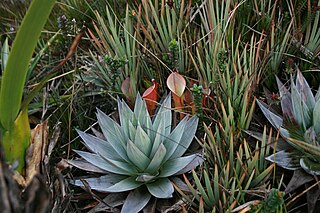
A tepui, or tepuy, is a table-top mountain or mesa found in South America, especially in Venezuela and western Guyana. The word tepui means "house of the gods" in the native tongue of the Pemon, the indigenous people who inhabit the Gran Sabana.

Mount Roraima is the highest of the Pacaraima chain of tepuis or plateaux in South America. It is located at the junction of Brazil, Guyana and Venezuela. A characteristic large flat-topped mountain surrounded by cliffs 400–1,000 m (1,300–3,300 ft) high. The highest point of Mount Roraima is located on the southern edge of the cliff at an elevation of 2,810 m (9,220 ft) in Venezuela, and another protrusion at an elevation of 2,772 m (9,094 ft) at the junction of the three countries in the north of the plateau is the highest point in Guyana. The name Mount Roraima came from the native Pemon people. Roroi in the Pemon language means "blue-green", and ma means "great".

The Pemon or Pemón (Pemong) are indigenous people living in areas of Venezuela, Brazil, and Guyana. The Pemon people are divided into many dialects and traditions, which are Arekuna, Kamarakoto, and Taurepang.

Canaima National Park is a 30,000 km2 (12,000 sq mi) park in south-eastern Venezuela that roughly occupies the same area as the Gran Sabana region. It is located in Bolívar State, reaching the borders with Brazil and Guyana. The park was named a World Heritage Site by UNESCO.
La Gran Sabana is a region in southeastern Venezuela, part of the Guianan savanna ecoregion.
The Pacaraima or Pakaraima Mountains are a mountain range primarily in southwestern Guyana, and into northern Brazil and eastern Venezuela.

The Guayana Region is an administrative region of eastern Venezuela.

Heliamphora nutans is a species of marsh pitcher plant native to the border area between Venezuela, Brazil and Guyana, where it grows on several tepuis, including Roraima, Kukenán, Yuruaní, Maringma, and Wei Assipu. Heliamphora nutans was the first Heliamphora to be described and is the best known species.
Cerro Sarisariñama is a tepui, a flat-topped mountain in Jaua-Sarisariñama National Park at the far south-west of Bolívar State, Venezuela, near the border with Brazil. Its altitude range is between 300 m (980 ft) and 2,350 m (7,710 ft). The name of the mountain originates from the tale of the local Ye'kuana people about an evil spirit living in caves up in the mountain and devouring human flesh with a sound "Sari... sari...".
Kukenán, also known as Matawi or Cuquenán, is a tepui in Bolívar State, Guayana Region, Venezuela. It has an estimated surface area of 2185 hectares. It is 2,680 metres (8,790 ft) high and about 3 km (1.9 mi) long. Kukenan Falls, which is 674 m (2,211 ft) high, is located at the south end of the tepui.
The natural range of the carnivorous plant genus Heliamphora is restricted to the southern Venezuelan states of Amazonas and Bolívar, and to adjacent portions of northern Brazil and western Guyana, an area corresponding to the western part of the Guayana Shield. These plants are largely confined to the summits and foothills of the sandstone table-top mountains of the region, known as tepuis.

The Eastern Tepuis, also known as the Roraima–Ilú range, is a mountain chain stretching for some 60 kilometres (37 mi) along the border between Guyana, Venezuela and, to a small extent, Brazil. It runs in a northwesterly direction from the tripoint of these countries, closely following the Guyana–Venezuela border, with a single major peak (Uei-tepui) to the south, on the Brazil–Venezuela border. Moving northwest from Uei-tepui (2,150 m), the main summits of this chain are Roraima-tepui (2,810 m), Kukenán-tepui (2,650 m), Yuruaní-tepui (2,400 m), Wadakapiapué-tepui (2,000 m), Karaurín-tepui (2,500 ), Ilú-tepui (2,700 m), and Tramen-tepui. The minor peak of Wei-Assipu-tepui lies entirely outside Venezuela, on the border between Brazil and Guyana. Additionally, there are a number of minor plateaus which form a chain between Uei-tepui and Roraima-tepui. Ilú- and Tramen-tepuis are often treated together since they are joined by a common base.
Wei-Assipu-tepui, also known as Little Roraima or Roraimita, is a minor tepui of the Eastern Tepuis chain. It lies just off the northeastern flank of Roraima-tepui in the country of Brazil, directly on the border with neighboring Guyana in the disputed Essequibo territory, and very close to the tripoint of all three countries. The mountain is known for its extensive cave systems, with one extending for over a kilometre.
Maringma-tepui, also written Mount Maringma and historically known as Mount Marima, is a small tepui of the Pacaraima Mountains in Cuyuni-Mazaruni, Guyana. It is known as Malaima-tepui in the local Akawaio language. Most published sources place it just inside Guyanese territory, very close to the border with Brazil, and around 17 kilometres (11 mi) east of Roraima-tepui. However, the mountain remains the subject of considerable toponymic confusion and its name has been applied to at least one other nearby peak.[nb a]

Monte Roraima National Park is a national park in the state of Roraima, northern Brazil.

The Guianan moist forests (NT0125) is an ecoregion in the east of Venezuela, north of Brazil and the Guyanas. It is in the Amazon biome. The climate is hot and humid, with two rainy seasons each year. As of 1996 the tropical rainforest habitat was relatively intact, although there were mounting threats from illegal logging and gold mining.
The Sierra de Lema flycatcher or Tepui flycatcher is a species of bird in the tyrant flycatcher family Tyrannidae. It is found in highland areas, including the table-top mountains (tepui), of southern Venezuela and the neighbouring parts of Brazil and Guiana. Its natural habitats are moist montane forests.
