The geography of France consists of a terrain that is mostly flat plains or gently rolling hills in the north and west and mountainous in the south and the east.
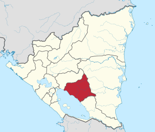
Chontales is a department in Nicaragua. It covers an area of 6,481.27 km² and has a population of 182,000. The capital is Juigalpa.

San Luis is a municipality in the Honduran department of Santa Bárbara.

Chiquimulilla is a municipality in the Santa Rosa department of Guatemala. It is located about 20 kilometres (12 mi) from the Pacific coast.

HMS Vittoria was a British destroyer of the Admiralty V-class. She was converted to a minelayer, and was torpedoed by the Bolshevik submarine Pantera off the island of Seiskari in the Gulf of Finland on 31 August 1919.

San Gregorio de Nigua is a municipality (municipio) of the San Cristóbal province in the Dominican Republic.

Flores de Ávila is a municipality located in the province of Ávila, Castile and León, Spain, about 164km from Madrid. According to the 2005 census (INE), the municipality has a population of 395 inhabitants.

Calzada del Coto is a municipality located in the province of León, Castile and León, Spain. According to the 2010 census (INE), the municipality has a population of 260 inhabitants.
Villanueva de Jiloca is a municipality on the river Jiloca, located in the province of Zaragoza, Aragon, Spain. According to the 2012 census (INE), the municipality has a population of 60 inhabitants.

Villa Hidalgo is a village in the municipality of Tuzantán, Chiapas, Mexico. As of 2010, the village had a population of 1,089.
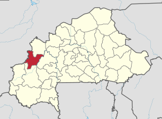
Bayé is a town in the Solenzo Department of Banwa Province in western Burkina Faso. As of 2005 it had a population of 5,478.
Tansila is a town and seat of the Tansila Department of Banwa Province in western Burkina Faso. In 2005 it had a population of 3,876.
Kougri is a village in the Zam Department of Ganzourgou Province in central Burkina Faso. The village has a population of 4110.

Wólka Modrzejowa is a village in the administrative district of Gmina Rzeczniów, within Lipsko County, Masovian Voivodeship, in east-central Poland. It lies approximately 7 kilometres (4 mi) south-west of Rzeczniów, 21 km (13 mi) south-west of Lipsko, and 129 km (80 mi) south of Warsaw.
Dyzin is a village in the administrative district of Gmina Celestynów, within Otwock County, Masovian Voivodeship, in east-central Poland. It lies approximately 4 kilometres (2 mi) north of Celestynów, 9 km (6 mi) south-east of Otwock, and 31 km (19 mi) south-east of Warsaw. As of 2014, the village had a population of 257.
Zalasewo is a village in the administrative district of Gmina Swarzędz, within Poznań County, Greater Poland Voivodeship, in west-central Poland. It lies approximately 3 kilometres (2 mi) south of Swarzędz and 12 km (7 mi) east of the regional capital Poznań.
Cotati was a 5,963 ton refrigerated cargo ship which was built in 1919. She was renamed Empire Avocet in 1942 and sunk by U-125 on 29 September 1942.
Malem Hodar Department is one of the 45 departments of Senegal, and is located in the Kaffrine Region. It was created as part of the new region in 2008.
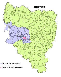
Alcalá del Obispo is a municipality in the province of Huesca, Spain. As of 2016, it has a population of 340 inhabitants.
Bni Gmil is a small town and rural commune in Al Hoceïma Province of the Taza-Al Hoceima-Taounate region of Morocco. At the time of the 2004 census, the commune had a total population of 9461 people living in 1313 households.