Mayotte Marine Natural Park

Last updated
Mayotte Marine Natural Park
French: Parc naturel marin de Mayotte
IUCN category V (protected landscape/seascape)
Coral lagoons, Mayotte.jpg
Barrier reefs separate Mayotte's lagoon from the ocean
Perimetre PNM Mayotte.png
Borders of Mayotte's EEZ, which the marine natural park entirely covers
Location Mayotte
Area68,300 km2 (26,400 sq mi)
Established2010 (2010)

The Mayotte Marine Natural Park (French : Parc naturel marin de Mayotte) is a marine park surrounding Mayotte, a French overseas region. Mayotte is part of the Comoro Islands archipelago, which lies within the Mozambique Channel in the western Indian Ocean. Established in 2010, the park covers the entirety of Mayotte's territorial waters and exclusive economic zone. It is contiguous with the Glorioso Islands Marine Natural Park, which was established two years later.

Contents

Habitats within the park include coral reefs, seagrass meadows, and the open ocean. There is a significant level of biodiversity, which includes a number of rare and endangered species. The park is important not just for wildlife, but for the people of Mayotte, with marine products being economically important to the territory.

Geography

The marine natural park covers the entirety of Mayotte's territorial waters and EEZ, totalling 68,300 square kilometres (26,400 sq mi). [1] :68–69 The reefs and lagoons surround over 30 islands and islets, in addition to the main island of Grande-Terre. [2] :8 The park is adjacent to the Glorioso Islands Marine Natural Park, [3] together forming a contiguous protected area covering 110,000 square kilometres (42,000 sq mi). [4]

The northern Mozambique channel, which the park lies within, is considered a hotspot for marine diversity. [5] :47 Mayotte's waters border those of Comoros, Madagascar, and the French territory of the Glorioso Islands, which is part of the French Southern and Antarctic Lands. [1] :64–65

History

The park was designated in 2010 [1] :69 through a Presidential decree issued on 18 January. [6] It is the first marine natural park established outside of Metropolitan France. [7] :2 Its creation may have been partially based on an attempt by France to better control the Mayotte area, which is claimed by Comoros. [1] :76–77

Marine biodiversity

Some coral reefs are exposed at low tide. MBouzi Patate Sud Grande Maree.JPG
Some coral reefs are exposed at low tide.

Mayotte has a rare lagoon surrounded by two barrier reefs, [8] which ranged from 30 metres (98 ft) to 80 metres (260 ft) deep. [2] :13 The outer barrier reef stretches over 179 kilometres (111 mi), with a width ranging from 800 metres (2,600 ft) to 1,500 metres (4,900 ft). Discontinuous internal reefs spanning 12 kilometres (7.5 mi) to the southwest of the island form the second barrier. Fringing reefs totalling 160 kilometres (99 mi) surround the main island and various islets. [2] :8 The reefs around Mayotte have the same composition as those in Comoros. [1] :67

Species that have been identified include 760 fish species, 581 arthropod species, 450 cnidarian species, and 24 marine mammals, [9] 24 fish species are on the IUCN Red List, including the endangered great hammerheads and humphead wrasse. [2] :26 8 of the coral species are protected by CITES. 971 species of molluscs have been identified, along with 597 crustaceans. [2] :23 The 89 species of echinoderms known include commercially valuable sea cucumbers. [2] :25 The reef fish population of Mayotte is more diverse than those of Réunion or the Scattered Islands in the Indian Ocean. [2] :26

Seagrass beds in sheltered areas support wildlife such as turtles and dugongs. 40 fish species have been found only around seagrass beds. Around 2000 turtles are estimated to live within the Mayotte lagoon. [2] :12 Five different turtle species are found around Mayotte, some of which nest on the region's beaches. [2] :27 96 sponge species have been identified within the lagoon. [2] :23

Risks facing Mayotte's biodiversity include pollution, habitat degradation, habitat destruction, invasive species, and climate change. [2] :5 Only 12% of the area within the lagoon are considered to be of good quality. [2] :10 By 2010, 50% of Mayotte's coral reefs were bleached. [5] :15 In some areas, reef coverage is so degraded they are almost completely gone. [2] :11 Some areas of coral have been seen to regenerate after bleaching events. [2] :12 The population of dugongs is perhaps as low as 10, following a history of unsustainable hunting. [2] :33 The Indo-Pacific humpback dolphin population in Mayotte is thought to be too small to survive. [2] :32

Governance

Turtles within the park are covered by a national action plan. Tortue verte et poisson-pilote.jpg
Turtles within the park are covered by a national action plan.

The park is run by the French Agency for Biodiversity  [ fr ], and has a management board consisting of 41 members, [6] including representatives of state and local government, professional organisations, local society, and environmental groups. [7] :2 The board develops an action plan for each year. [2] :63 A 15-year management plan was established in January 2013. [2] :83

The park is responsible for implementing the National Action Plan for sea turtles in its area of jurisdiction. [2] :27 A National Action Plan for dugongs was implemented in 2012. [2] :33 The park also supports educational activities for schools in Mayotte. [2] :87 [7] Some conservation programmes are conducted jointly with the TAAF administration, which runs the neighbouring Glorioso Islands Marine Natural Park. [5] :53

The France Nature Environnement organisation has criticised the level of actual protection, noting commercial fishing continues within the park. [10] Most fishing however remains line fishing. Oceanic tuna fishing vessels are not allowed to fish within 24 miles of the coast. [2] :50 Marine products make up 63% of Mayotte's exports. [1] :70

The park is listed under the IUCN protected area categories system as a protected seascape (category V). [11]

Related Research Articles

<span class="mw-page-title-main">Glorioso Islands</span> Archipelago in the Scattered Islands in the Indian Ocean

The Glorieuses or Glorioso Islands are a group of islands and rocks totaling 5 square kilometres (1.9 sq mi). They are controlled by France as part of the Scattered Islands in the Indian Ocean in the French Southern and Antarctic Lands, a French overseas territory, but are also claimed by Comoros, Madagascar and formerly by Seychelles. They are geographically part of the Comoro Islands between the French overseas region of Mayotte and the nation of Madagascar.

<span class="mw-page-title-main">Mayotte</span> Overseas department of France in the Indian Ocean

Mayotte, officially the Department of Mayotte, is an overseas department and region and single territorial collectivity of France. It is located in the northern part of the Mozambique Channel in the Indian Ocean off the coast of Southeastern Africa, between Northwestern Madagascar and Northeastern Mozambique. Mayotte consists of a main island, Grande-Terre, a smaller island, Petite-Terre, as well as several islets around these two. Mayotte is the most prosperous territory in the Mozambique Channel, making it a major destination for immigration.

<span class="mw-page-title-main">Aldabra</span> Coral atoll in the Indian Ocean

Aldabra, the world's second-largest coral atoll, is located southeast of the continent of Africa. It is part of the Aldabra Group of islands in the Indian Ocean that are part of the Outer Islands of the Seychelles, with a distance of 1,120 km (700 mi) southwest of the capital, Victoria on Mahé Island. Initially named by Arab seafarers for its harsh environment, Aldabra became a French colony dependency in the 18th century, leading to the exploitation of its natural resources, particularly giant tortoises. After passing through British hands, Aldabra faced potential military use in the 1960s, but international protests resulted in its protection. The atoll boasts unique geography, featuring the world's largest raised coral reef and a large shallow lagoon. Aldabra's history involves human impact, including failed agricultural ventures.

<span class="mw-page-title-main">Marine park</span> Protected marine area for conservation purposes

A marine park is a designated park consisting of an area of sea set aside to achieve ecological sustainability, promote marine awareness and understanding, enable marine recreational activities, and provide benefits for Indigenous peoples and coastal communities. Most marine parks are managed by national governments, and organized like 'watery' national parks, whereas marine protected areas and marine reserves are often managed by a subnational entity or non-governmental organization, such as a conservation authority.

<span class="mw-page-title-main">Comoro Islands</span> Archipelago in the Indian Ocean

The Comoro Islands are a group of volcanic islands in the Mozambique Channel, an arm of the Indian Ocean lying between Madagascar and the African mainland. Three of the islands form the Union of the Comoros, a sovereign nation, while Mayotte belongs to France.

<span class="mw-page-title-main">New Caledonian barrier reef</span> Barrier reef in the South Pacific

The New Caledonian barrier reef is a barrier reef located in New Caledonia in the South Pacific, being the longest continuous barrier reef in the world and the third largest after the Great Barrier Reef of Australia and the Mesoamerican Barrier Reef.

<span class="mw-page-title-main">Banc du Geyser</span> Disputed territory and reef in the Mozambique Channel

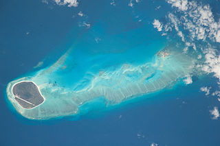
Banc du Geyser is a mostly submerged reef in the Mozambique Channel's northeastern part, 125 km (78 mi) northeast from Mayotte, 112 km (70 mi) southwest of the Glorioso Islands and 200 km (124 mi) off the northwestern coast of Madagascar.

<span class="mw-page-title-main">Mnazi Bay-Ruvuma Estuary Marine Park</span> A marine park in Tanzania

The Mnazi Bay-Ruvuma Estuary Marine Park(MBREMP) was established on 1 July 2000 under Act No. 29 of 1994 of Marine Parks and Reserves of Tanzania.

<span class="mw-page-title-main">Moreton Bay Marine Park</span> Protected area in Queensland, Australia

The Moreton Bay Marine Park was established in 1993 to protect ecologically significant habitats in Moreton Bay. The marine park extends from Caloundra south to the southern tip of South Stradbroke Island. The marine park's border extends up to the highest tidal mark and covers a total of 3,400 km2.

<span class="mw-page-title-main">Kadmat Island</span> Coral island of the Lakshadweep archipelago in India

Kadmat Island, also known as Cardamom Island, is a coral island belonging to the Amindivi subgroup of islands of the Lakshadweep archipelago in India. Measuring 9.3 kilometres (5.8 mi) in length, the island has a lagoon with a width of 1.5 kilometres (0.93 mi) covering an area of 25 square kilometres (9.7 sq mi). The ecological feature of the island is of coral reef with seagrass, and marine turtles which nestle here. The Ministry of Environment and Forests (India) has notified the island as a marine protected area for ensuring conservation of the island's animal, plant, or other type of organism, and other resources.

<span class="mw-page-title-main">Hikkaduwa National Park</span> National Park in Sri Lanka

Hikkaduwa National Park is one of the three marine national parks in Sri Lanka. The national park contains a fringing coral reef of high degree of biodiversity. The area was declared a wildlife sanctuary on May 18, 1979, and then on August 14, 1988, upgraded to a nature reserve with extended land area. The growth of the number of visitors in the next 25 years increased the degradation of the coral reef. To reduce the effects to the ecosystem, the reef was declared a national park on September 19, 2002.

<span class="mw-page-title-main">Bu Tinah</span> Protected archipelago in United Arab Emirates

Bu Tinah is a tiny archipelago amid extensive coral formations and seagrass beds some 25 km south of Zirku and 35 north of Marawah in the United Arab Emirates. Found in the waters of Abu Dhabi, it is protected as a private nature reserve. Bu Tinah Island, rich in biodiversity, lies within the Marawah Marine Biosphere Reserve with a territory of more than 4,000 km2. The biosphere reserve is the region's first and largest UNESCO-designated marine biosphere reserve. It has been a recognized UNESCO site since 2001. Closed to visitors, fishing and the collection of turtle eggs are prohibited on Bu Tinah Island; the ban being enforced by patrols. An Environment Agency-Abu Dhabi Ranger Station is located on the island.

<span class="mw-page-title-main">Bazaruto Archipelago National Park</span> Marine and terrestrial protected area in the Bazaruto Archipelago in Mozambique

The Bazaruto Archipelago National Park (BANP) is a protected area in the Inhambane Province of Mozambique on the Bazaruto Archipelago. The park was proclaimed on 25 May 1971. It is off the coast of the Vilanculos and Inhassoro districts, covering a large expanse of ocean and five islands.

<span class="mw-page-title-main">Lampi Island Marine National Park</span> Marine national park in Myanmar

The Lampi Island Marine National Park is a marine national park in Myanmar covering 79.09 sq mi (204.8 km2). It was established in 1996. It encompasses Lanbi Island and several smaller islands in the Mergui Archipelago, comprising coral reefs, seagrass beds, mangroves, sand dunes and tropical evergreen forest up to an elevation of 1,493 ft (455 m). The national park is an Important Bird Area and one of the ASEAN Heritage Parks. The characteristics of the Marine National Park are the tropical evergreen rainforest, the vast coral reef systems that protect a wide range of aquatic ecosystems, and significant biodiversity in this area. Access is restricted to daytime visits.

<span class="mw-page-title-main">Mohéli National Park</span> National park in the Comoros

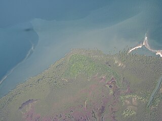
Mohéli National Park is a national park in the Comoros. It includes marine, coastal, and terrestrial areas on and around the island of Mohéli. The park has an area of 643.62 km2. Established as Mohéli Marine Park on 19 April 2001, it was first protected area in the Comoros. It was redesignated a national park in 2010. In 2015 the park was expanded to include about three-quarters of Mohéli's terrestrial area. It is the southernmost territory of the southernmost Arabic-speaking country.

<span class="mw-page-title-main">Ashmore Reef Marine Park</span> Protected marine park in Australia

The Ashmore Reef Marine Park is an Australian marine park that covers the Ashmore Reef, which is located about 630 km (390 mi) north of Broome and 110 km (68 mi) south of the Indonesian island of Rote. The marine park covers an area of 583 km2 (225 sq mi) and is assigned IUCN category Ia. It is one of 13 parks managed under the North-west Marine Parks Network.

The East African coral coast is a marine ecoregion along the eastern coast of Africa. It extends along the coasts of Kenya, Tanzania, and northern Mozambique, from Lamu in Kenya to Angoche in Mozambique. It adjoins the Northern Monsoon Current Coast ecoregion to the north, and the Bight of Sofala/Swamp Coast ecoregion to the south.

The Northern Monsoon Current coast is a marine ecoregion along the eastern coast of Africa. It extends along a portion of the coasts of Somalia and Kenya, from south of Lamu in Kenya to north of Mogadishu in Somalia. It adjoins the Central Somali coast ecoregion to the north, and the East African coral coast ecoregion to the south.

<span class="mw-page-title-main">Glorioso Islands Marine Natural Park</span>

The Glorioso Islands Marine Natural Park is a marine park at the entrance of the Mozambique Channel, around the Glorioso Islands, in the Indian Ocean. It extends for more than 43,000 square kilometres (17,000 sq mi) until the edge of the French overseas territory's exclusive economic zone. Established in 2012, it is the fourth marine natural park created by France and the second in the Indian Ocean after Mayotte Marine Natural Park, which it abuts.

<span class="mw-page-title-main">Protected areas of Solomon Islands</span> Protected areas in Solomon Islands

Protected areas of Solomon Islands include marine protected areas that encompass coral reefs, lagoons, and seagrass meadows. East Rennell, which includes Lake Tegano, is the only area in the Solomon Islands listed by UNESCO as a World Heritage Site. As of April 2024, the Solomons have not nominated any wetlands under the Convention on Wetlands of International Importance.

References

  1. 1 2 3 4 5 6 Levin, Noam; Beger, Maria; Maina, Joseph; McClanahan, Tim; Kark, Salit (1 February 2018). "Evaluating the potential for transboundary management of marine biodiversity in the Western Indian Ocean". Australasian Journal of Environmental Management. 25 (1): 62–85. doi: 10.1080/14486563.2017.1417167 . S2CID   56449567.
  2. 1 2 3 4 5 6 7 8 9 10 11 12 13 14 15 16 17 18 19 20 21 22 Cremades, Caroline (April 2013). Proposition pour une stratégie biodiversité en vue d'un développement durablede Mayotte (PDF) (in French). IUCN. ISBN   978-2-918105-28-2.
  3. OECD Review of Fisheries: Policies and Summary Statistics 2013. OECD Publishing. 2013. p. 184. ISBN   9789264203440.
  4. "Parc naturel marin des Glorieuses : un espace protégé au cœur de l'océan Indien" (in French). Terres Australes et Antarctiques Françaises. Retrieved 17 January 2021.
  5. 1 2 3 "Overseas Countries and Territories: Environmental Profiles". European Commission. January 2015. Retrieved 15 January 2021.
  6. 1 2 Bigot, L.; Chabanet, P.; Cuet, P.; Cauvin, B.; Durville, P.; Mulochau, T; Naim, O.; Nicet, J.B.; Tessier, E.; Thomassin, B.; Wickel, J. (2019). "Chapter 13 - French Territories in the Western Indian Ocean". World Seas: an Environmental Evaluation (Second ed.). Academic Press. doi:10.1016/B978-0-08-100853-9.00011-7. ISBN   978-0-08-100853-9. S2CID   134154856.
  7. 1 2 3 "Appel a projects pédagogiques" (PDF) (in French). Parc naturel marin de Mayotte. Retrieved 20 January 2021.
  8. "Biodiversity in France". IUCN. Retrieved 20 January 2021.
  9. "Mayotte (France)". IUCN. Retrieved 20 January 2021.
  10. Senet, Stéphanie (29 October 2019). "Only 1.5% of France's waters are truly protected, expert says". Euractiv. Retrieved 20 January 2021.
  11. "FR9100002 – Mayotte" (in French). Muséum national d’histoire naturelle. Retrieved 20 January 2021.