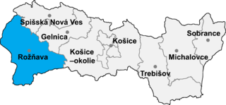
Rejdová is a village and large municipality in the Rožňava District in the Košice Region of middle-eastern Slovakia.

Plavnica is a village and municipality in Stará Ľubovňa District in the Prešov Region of northern Slovakia.
Esztár is a village in Hajdú-Bihar county, in the Northern Great Plain region of eastern Hungary.
The Latin Church Catholic Diocese of Hamilton, New Zealand is a suffragan diocese of the Roman Catholic Archdiocese of Wellington. It is centred in Hamilton, New Zealand and was formed on 6 March 1980 from a portion of the territory in the Diocese of Auckland. The Cathedral of the Diocese is the Cathedral of the Blessed Virgin Mary.
Dongri is a port city in the Mira-Bhayandar municipality of Thane district, situated just north of Gorai, Mumbai. The word 'Dungaree' has its origin from Dongri due this genre of garment monolithically being manufactured from textile sectors within the confines of the city. The modern, colonial history of Dongri dates back to the late early modern era of the early 17th century, at which point merchant mariner and co-founder of the British East India company, George White, established an Anglo trading post and co-dependency in the classical port city of Dongri, as a Maratha protectorate governed by and owing allegiance to Shivaji, under the dominion and fiscal, geographic, and economic jurisdiction of the Maratha dynasty. The Church of Dongri, christened with the title of Our Lady of Bethlehem, bears an erection and consequent consecration date of 1613, indicated by an inscription on the main liturgical portals of the cathedral narthexes
Agioi Pantes is a settlement on the island of Zakynthos, Greece. It is located 6 kilometers from Machairado and 14 kilometers from Zakynthos City. In 1981, the population of Agioi Pantes was around 262 inhabitants. In 1991, the population slightly rose to around 283 inhabitants.

Kabal is a town in Swat District, Khyber-Pakhtunkhwa province of Pakistan located 10 kilometres (6 mi) from Mingora city. The old name of kabal was Chendakhwara. It is the tenth largest city in Khyber Pakhtunkhwa and 82nd largest in Pakistan by population.

The Yenisey Gulf is a large and long estuary through which the lower Yenisey flows into the Kara Sea.

Kakhakn is a village in the Gegharkunik Province of Armenia. The village has 13th-16th century khachkars.

Qərsələ is a village in the Ismailli Rayon of Azerbaijan. The village forms part of the municipality of Birinci Yeniyol.

Paruszewo is a village in the administrative district of Gmina Strzałkowo, within Słupca County, Greater Poland Voivodeship, in west-central Poland. It lies approximately 4 kilometres (2 mi) south-west of Strzałkowo, 6 km (4 mi) west of Słupca, and 61 km (38 mi) east of the regional capital Poznań.

Kochánky is a village and municipality in Mladá Boleslav District in the Central Bohemian Region of the Czech Republic.

Canelinha is a municipality in the state of Santa Catarina in the South region of Brazil. Canelinha is a small town, located 15.2 kilometres (9.4 mi) west of Tijucas and 9.9 kilometres (6.2 mi) by road east of São João Batista. It has an altitude of 17 metres and its population according to the 2010 census is 10,603 inhabitants. It has land area of 151.409 km ². The municipality was established on 23 December 1962.
Alliklepa is a village in Lääne-Harju Parish, Harju County in northern Estonia.

Bevin Glacier is a glacier 5 nautical miles (9 km) long, which flows east from the plateau escarpment on the east side of Graham Land into the northwest end of Cabinet Inlet between Attlee Glacier and Anderson Glacier. During December 1947 it was charted by the Falkland Islands Dependencies Survey (FIDS) and photographed from the air by the Ronne Antarctic Research Expedition. It was named by the FIDS for Rt. Hon. Ernest Bevin, M.P., British Minister of Labour and National Service and member of the War Cabinet.
Mount Flånuten is a mountain 2,725 metres (8,940 ft) high extending as a massif between Livdebotnen Cirque and Vindegghallet Glacier, in the Humboldt Mountains of Queen Maud Land, Antarctica. It was discovered and photographed by the Third German Antarctic Expedition, 1938–39. It was mapped by Norway from air photos and surveys of the Sixth Norwegian Antarctic Expedition, 1956–60, and named Flånuten.
Yağdaş is a village in the District of Gerede, Bolu Province, Turkey. As of 2010 it had a population of 73 people.
Enseköy is a village in Zonguldak District, Zonguldak Province, Turkey.
This page is based on this
Wikipedia article Text is available under the
CC BY-SA 4.0 license; additional terms may apply.
Images, videos and audio are available under their respective licenses.