The Amundsen Sea, an arm of the Southern Ocean off Marie Byrd Land in western Antarctica, lies between Cape Flying Fish to the east and Cape Dart on Siple Island to the west. Cape Flying Fish marks the boundary between the Amundsen Sea and the Bellingshausen Sea. West of Cape Dart there is no named marginal sea of the Southern Ocean between the Amundsen and Ross Seas. The Norwegian expedition of 1928–1929 under Captain Nils Larsen named the body of water for the Norwegian polar explorer Roald Amundsen while exploring this area in February 1929.

Operation HIGHJUMP, officially titled The United States Navy Antarctic Developments Program, 1946–1947,, was a United States Navy (USN) operation to establish the Antarctic research base Little America IV. The operation was organized by Rear Admiral Richard E. Byrd, Jr., USN (Ret), Officer in Charge, Task Force 68, and led by Rear Admiral Ethan Erik Larson, USN, Commanding Officer, Task Force 68. Operation HIGHJUMP commenced 26 August 1946 and ended in late February 1947. Task Force 68 included 4,700 men, 13 ships, and 33 aircraft.

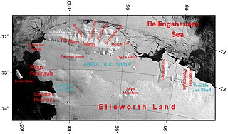
The Abbot Ice Shelf is an ice shelf 250 mi (400 km) long and 40 mi (60 km) wide, bordering Eights Coast from Cape Waite to Pfrogner Point in Antarctica. Thurston Island lies along the northern edge of the western half of this ice shelf; other sizable islands lie partly or wholly within this shelf.

The Branscomb Glacier is an Antarctic glacier, 11 nautical miles long, flowing west from the north-west side of Vinson Massif into Nimitz Glacier, in the Sentinel Range of the Ellsworth Mountains. Its upper course receives ice influx from both Goodge Col and Jacobsen Valley, while the tributary Roché Glacier joins Branscomb Glacier just northwest of Príncipe de Asturias Peak.
The Ronne Antarctic Research Expedition (RARE) was an expedition from 1947–1948 which researched the area surrounding the head of the Weddell Sea in Antarctica.

The Windmill Islands are an Antarctic group of rocky islands and rocks about 11.1 kilometres (6 nmi) wide, paralleling the coast of Wilkes Land for 31.5 kilometres (17 nmi) immediately north of Vanderford Glacier along the east side of Vincennes Bay. Kirkby Shoal is a small shoal area with depths of less than 18 metres (59 ft) extending about 140 metres (459 ft) westwards and SSW, about 3.4 kilometres (2.1 mi) from the summit of Shirley Island, Windmill Islands, and 0.24 kilometres (0.15 mi) NW of Stonehocker Point, Clark Peninsula.

Holl Island is a rocky, triangular-shaped Antarctic island, 3.1 km (1.7 nmi) long, marking the south-western end of the Windmill Islands.
The Bailey Rocks are small chain of rocks in the Antarctic Windmill Islands which extends northeast from the north side of Bailey Peninsula into Newcomb Bay. They were first mapped from air photos taken by USN Operation Highjump, 1946–47, and observed in 1957 by Wilkes Station personnel under C. R. Eklund.

Peterson Island is a rocky island, 3.5 km (2.2 mi) long, with two inlets indenting the north side, lying west of, and separated by a narrow channel 200-400 m wide from, the Browning Peninsula, in the southern part of the Windmill Islands on the Budd Coast of Wilkes Land, Antarctica.
Herring Island is an Antarctic rocky island, 3.7 km (2 nmi) long, lying 1.9 km (1 nmi) east of Cloyd Island in the south part of the Windmill Islands. It was first mapped from air photos taken by USN Operation Highjump and Operation Windmill in 1947 and 1948. Named by the US-ACAN for Lt. Charles C. Herring, USN, photographic officer with Operation Windmill parties which obtained air and ground photos of the area in January 1948.
Bousquet Island, 0.6 kilometres (0.3 nmi) long, lies immediately east of Herring Island in the Windmill Islands. It was first mapped from air photos taken by USN Operation Highjump in 1946 and 1947. Named by C. R. Eklund, station scientific leader, for Utilities Man 2nd Class Edward A. Bousquet, USN, a Navy Support force member of the 1957 wintering party at Wilkes Station during the International Geophysical Year (IGY).
Bøving Island is a small Antarctic island in the south part of Newcomb Bay, lying 0.2 km (0.1 nmi) east of McMullin Island in the Windmill Islands. It was first mapped from air photos taken by USN Operation Highjump in 1946 and 1947. Named by ANCA for F. Bøving, third officer on MV Thala Dan in 1965, who assisted in a hydrographic survey in the vicinity.
Fitzpatrick Rock is a low ice-capped rock lying 1 kilometre northwest of Kilby Island at the mouth of Newcomb Bay, in the Windmill Islands, Antarctica. It was first charted in February 1957 by a party from the USS Glacier. The name was suggested by Lt. Robert C. Newcomb, USN, navigator of the Glacier, for Boatswain's Mate 2nd Class John Fitzpatrick, USN, member of the survey party.

Kilby Island is a rocky Antarctic island, 0.37 kilometres (0.2 nmi) long, lying northeast of McMullin Island in the entrance of Newcomb Bay, in the Windmill Islands. It was first mapped from air photos taken by USN Operation Highjump and Operation Windmill in 1947 and 1948. It was named by the US-ACAN for Arthur L. Kilby, who served as photographer with both operations.

The Sikorski Glacier is a small glacier in the north-eastern part of the Noville Peninsula, Thurston Island, Ellsworth Land, Antarctica. It flows north-east to the Bellingshausen Sea between Mount Palmer and Mount Feury. It was first roughly delineated from aerial photos taken by the USN's Operation Highjump in 1946–47. It was named by the Advisory Committee on Antarctic Names (US-ACAN) for Stephen Sikorski, electronics technician on USS Glacier, who assisted in setting up an automatic weather station on Thurston Island during the USN's Bellingshausen Sea Expedition in February 1960.

Clark Peninsula is a rocky peninsula, about 3 km (2 mi) long and wide, lying 5 km (3 mi) north-east of Australia's Casey Station at the north side of Newcomb Bay on the Budd Coast of Wilkes Land in Antarctica.
Oakley Glacier, is a glacier in the Mountaineer Range that descends east from Mount Casey to merge with the floating tongue from the Icebreaker Glacier at Lady Newnes Bay, in Victoria Land, Antarctica. Mapped by U.S. Geological Survey (USGS) from surveys and U.S. Navy air photos, 1960–64. Named by Advisory Committee on Antarctic Names (US-ACAN) for Lieutenant Commander Donald C. Oakley, U.S. Navy (USN), Protestant chaplain with the winter party at McMurdo Station, 1967.
Wohlschlag Bay is a large bay indenting the western side of Ross Island, Antarctica, and lying between Harrison Bluff and Cape Royds. It was first charted by the Discovery Expedition under Robert Falcon Scott, 1901–1904, then named by the Advisory Committee on Antarctic Names (US-ACAN) in 1964 for Donald E. Wohlschlag, professor of biology at Stanford University, who outfitted the biology laboratories on the USNS Eltanin and at McMurdo Station.

Coulter Glacier is a steeply inclined glacier, 5 nautical miles (9 km) long, flowing south from the Havre Mountains, northern Alexander Island, into Kolokita Cove in Lazarev Bay, Antarctica. The glacier was photographed from the air by the Ronne Antarctic Research Expedition in 1947 and mapped from the photographs by the Falkland Islands Dependencies Survey in 1960. It was named by the Advisory Committee on Antarctic Names for R.W. Coulter, Master of USNS Alatna during U.S. Navy Operation Deepfreeze, 1969.
The Schaefer Islands are a small group of islands lying close to the north-western end of the Canisteo Peninsula and 4 km (2.5 mi) south-west of the Lindsey Islands. They were mapped from aerial photos taken by the USN's Operation Highjump in December 1946. They were named by the Advisory Committee on Antarctic Names (US-ACAN) for William A. Schaefer, a geologist on the Ellsworth Land Survey, 1968–69.


