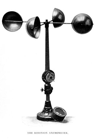
Measurement tower

Last updated
The measurement tower of Forschungszentrum Karlsruhe Forschungszentrum.Karlsruhe.-.Measurement.Tower.png
The measurement tower of Forschungszentrum Karlsruhe

A measurement tower or measurement mast, also known as meteorological tower or meteorological mast (met tower or met mast), is a free standing tower or a removed mast, which carries measuring instruments with meteorological instruments, such as thermometers and instruments to measure wind speed. Measurement towers are an essential component of rocket launching sites, since one must know exact wind conditions for an execution of a rocket launch. Met masts are crucial in the development of wind farms, as precise Knowledge of the wind speed is necessary to know how much energy will be produced, and whether the turbines will survive on the site. Measurement towers are also used in other contexts, for instance near nuclear power stations, and by ASOS stations.

Contents

Examples

Meteorology

StructureCity or regionCountryHeight (metres)Year builtNotes
Amazon Tall Tower Observatory Vila de BalbinaFlag of Brazil.svg  Brazil 3252015 [1]
IAP Meteorological Tower BeijingFlag of the People's Republic of China.svg  China 3251979for meteorological measurements, studies of air pollution and studies of the atmospheric boundary layer
Obninsk Meteorological tower ObninskFlag of Russia.svg  Russia 3101958for meteorological and radioactivity measurements
Zotino Tall Tower Observation Facility ZotinoFlag of Russia.svg  Russia 302for measurements of meteorological variables and of concentration of greenhouse gases and aerosols
KNMI-mast Cabauw CabauwFlag of the Netherlands.svg  Netherlands 2131972for meteorological research
Jaslovské Bohunice Meteorological Tower Jaslovské BohuniceFlag of Slovakia.svg  Slovakia 2121986 [2]
Meteorological tower of Forschungszentrum Karlsruhe KarlsruheFlag of Germany.svg  Germany 2001972
Rödeser Berg Meteorological MastWolfshagenFlag of Germany.svg  Germany 2002011
KFU-Tower GundremmingenGundremmingenFlag of Germany.svg  Germany 1741978
KFU-Mast GrafenrheinfeldGrafenrheinfeldFlag of Germany.svg  Germany 1641978for the measurement of meteorological parameters and environmental radioactivity
Mast of Richard Assmann ObservatoryFalkenbergFlag of Germany.svg  Germany 991998
Mast of Asbach ObrigheimFlag of Germany.svg  Germany dismantled
Oskar-von-Miller-Tower Garching Flag of Germany.svg  Germany 622010
Mast of Dukovany Nuclear Power Station Dukovany Flag of the Czech Republic.svg  Czech Republic
Košetice Meteorological Tower Košetice Flag of the Czech Republic.svg  Czech Republic 2502012 [3]
Hegyhátsál TV Tower Hegyhátsál Flag of Hungary.svg  Hungary 117transmission tower equipped with instruments for the measurement of meteorological parameters and carbon dioxide concentration
Norunda tower Uppsala County Flag of Sweden.svg  Sweden 103 [4]
Puijo tower Kuopio Flag of Finland.svg  Finland 751963
NAVO-Toren Veurne Flag of Belgium (civil).svg  Belgium 243 [5]

Other measurement towers

Wind farm development

Before developers construct a wind farm, they first measure the wind resource on a prospective site by erecting temporary measurement towers. Typically these mount anemometers at a range of heights up to the hub height of the proposed wind turbines, and log the wind speed data at frequent intervals (e.g. every ten minutes) [6] for at least one year and preferably two or more. The data allow the developer to determine if the site is economically viable for a wind farm, and to choose wind turbines optimized for the local wind speed distribution.

See also

Related Research Articles

<span class="mw-page-title-main">Anemometer</span> Meteorological instrumentation used for measuring the speed of wind

An anemometer is a device that measures wind speed and direction. It is a common weather station instrument. The term is derived from the Greek word anemos (wind), and is used to describe any wind-speed instrument used in meteorology. The earliest known description of an anemometer was by Italian architect and author Leon Battista Alberti (1404–1472) in 1450.

<span class="mw-page-title-main">Wind speed</span> Rate at which air moves from high- to low-pressure areas

In meteorology, wind speed, or wind flow speed, is a fundamental atmospheric quantity caused by air moving from high to low pressure, usually due to changes in temperature. Wind speed is now commonly measured with an anemometer.

<span class="mw-page-title-main">Weather station</span> Facility for atmospheric research and prediction

A weather station is a facility, either on land or sea, with instruments and equipment for measuring atmospheric conditions to provide information for weather forecasts and to study the weather and climate. The measurements taken include temperature, atmospheric pressure, humidity, wind speed, wind direction, and precipitation amounts. Wind measurements are taken with as few other obstructions as possible, while temperature and humidity measurements are kept free from direct solar radiation, or insolation. Manual observations are taken at least once daily, while automated measurements are taken at least once an hour. Weather conditions out at sea are taken by ships and buoys, which measure slightly different meteorological quantities such as sea surface temperature (SST), wave height, and wave period. Drifting weather buoys outnumber their moored versions by a significant amount.

<span class="mw-page-title-main">Apparent wind</span> Wind experienced by a moving object

Apparent wind is the wind experienced by a moving object.

<span class="mw-page-title-main">Automatic weather station</span> Meteorological instrument

An automatic weather station (AWS) is an automated version of the traditional weather station, either to save human labour or to enable measurements from remote areas. An AWS will typically consist of a weather-proof enclosure containing the data logger, rechargeable battery, telemetry (optional) and the meteorological sensors with an attached solar panel or wind turbine and mounted upon a mast. The specific configuration may vary due to the purpose of the system. The system may report in near real time via the Argos System, LoRa and the Global Telecommunications System, or save the data for later recovery.

<span class="mw-page-title-main">Roughness length</span> Parameter of some vertical wind profile equations

Roughness length is a parameter of some vertical wind profile equations that model the horizontal mean wind speed near the ground. In the log wind profile, it is equivalent to the height at which the wind speed theoretically becomes zero in the absence of wind-slowing obstacles and under neutral conditions. In reality, the wind at this height no longer follows a mathematical logarithm. It is so named because it is typically related to the height of terrain roughness elements. For instance, forests tend to have much larger roughness lengths than tundra. The roughness length does not exactly correspond to any physical length. However, it can be considered as a length-scale representation of the roughness of the surface.

<span class="mw-page-title-main">Wind direction</span>

Wind direction is generally reported by the direction from which it originates. For example, a north or northerly wind blows from the north to the south. The exceptions are onshore winds and offshore winds. Wind direction is usually reported in cardinal direction, or in degrees. Consequently, a wind blowing from the north has a wind direction referred to as 0° (360°); a wind blowing from the east has a wind direction referred to as 90°, etc.

<span class="mw-page-title-main">FLUXNET</span>

FLUXNET is a global network of micrometeorological tower sites that use eddy covariance methods to measure the exchanges of carbon dioxide, water vapor, and energy between the biosphere and atmosphere. FLUXNET is a global 'network of regional networks' that serves to provide an infrastructure to compile, archive and distribute data for the scientific community. The most recent FLUXNET data product, FLUXNET2015, is hosted by the Lawrence Berkeley National Laboratory (USA) and is publicly available for download. Currently there are over 1000 active and historic flux measurement sites.

<span class="mw-page-title-main">Meteorological instrumentation</span>

Meteorological instruments, including meteorological sensors, are the equipment used to find the state of the atmosphere at a given time. Each science has its own unique sets of laboratory equipment. Meteorology, however, is a science which does not use much laboratory equipment but relies more on on-site observation and remote sensing equipment. In science, an observation, or observable, is an abstract idea that can be measured and for which data can be taken. Rain was one of the first quantities to be measured historically. Two other accurately measured weather-related variables are wind and humidity. Many attempts had been made prior to the 15th century to construct adequate equipment to measure atmospheric variables.

<span class="mw-page-title-main">Outline of meteorology</span> Overview of and topical guide to meteorology

The following outline is provided as an overview of and topical guide to the field of Meteorology.

<span class="mw-page-title-main">Surface weather observation</span> Fundamental data used for weather forecasts

Surface weather observations are the fundamental data used for safety as well as climatological reasons to forecast weather and issue warnings worldwide. They can be taken manually, by a weather observer, by computer through the use of automated weather stations, or in a hybrid scheme using weather observers to augment the otherwise automated weather station. The ICAO defines the International Standard Atmosphere (ISA), which is the model of the standard variation of pressure, temperature, density, and viscosity with altitude in the Earth's atmosphere, and is used to reduce a station pressure to sea level pressure. Airport observations can be transmitted worldwide through the use of the METAR observing code. Personal weather stations taking automated observations can transmit their data to the United States mesonet through the Citizen Weather Observer Program (CWOP), the UK Met Office through their Weather Observations Website (WOW), or internationally through the Weather Underground Internet site. A thirty-year average of a location's weather observations is traditionally used to determine the station's climate. In the US a network of Cooperative Observers make a daily record of summary weather and sometimes water level information.

<span class="mw-page-title-main">Chesapeake Light</span> Lighthouse in Virginia, United States

Chesapeake Light is an offshore lighthouse marking the entrance to the Chesapeake Bay. The structure was first marked with a lightship in the 1930s, and was later replaced by a "Texas Tower" in 1965. The lighthouse was eventually automated and was used for supporting atmospheric measurement sites for NASA and NOAA. Due to deteriorating structural conditions, the lighthouse was deactivated in 2016. At the time it was the last remaining "Texas Tower" still in use due to obsolescence.

Wind resource assessment is the process by which wind power developers estimate the future energy production of a wind farm. Accurate wind resource assessments are crucial to the successful development of wind farms.

<span class="mw-page-title-main">Rover Environmental Monitoring Station</span>

Rover Environmental Monitoring Station (REMS) is a weather station on Mars for Curiosity rover contributed by Spain and Finland. REMS measures humidity, pressure, temperature, wind speeds, and ultraviolet radiation on Mars. This Spanish project is led by the Spanish Astrobiology Center and includes the Finnish Meteorological Institute as a partner, contributing pressure and humidity sensors.

<span class="mw-page-title-main">Anna Mani</span> Indian physicist and meteorologist (1918–2001)

Anna Mani was an Indian physicist and meteorologist. She retired as the Deputy Director General of the Indian Meteorological Department and also served as a visiting professor at the Raman Research Institute. Mani made contributions to the field of meteorological instrumentation, conducted research, and published numerous papers on solar radiation, ozone, and wind energy measurements.

<span class="mw-page-title-main">Østerild Wind Turbine Test Field</span>

Østerild Wind Turbine Test Field is a facility managed by the DTU Risø Campus of the Technical University of Denmark (DTU) for testing of offshore wind turbines with a pinnacle height up to 330 metres (1,080 ft) near Thisted-Østerild, Denmark.

<span class="mw-page-title-main">Näsudden</span>

Näsudden is a peninsula on the south coast of Gotland, Sweden. The first tests for using wind power on a large scale in Sweden, were conducted there in the 1970s. The area has since been developed into a wind farm. Part of the peninsula is a nature reserve for birds and grey seals.

Global terrestrial stilling is the decrease of wind speed observed near the Earth's surface over the last three decades, originally termed "stilling". This slowdown of near-surface terrestrial winds has mainly affected mid-latitude regions of both hemispheres, with a global average reduction of −0.140 m s−1 dec−1 or between 5 and 15% over the past 50 years. With high-latitude showing increases in both hemispheres. In contrast to the observed weakening of winds over continental surfaces, winds have tended to strengthen over ocean regions. In the last few years, a break in this terrestrial decrease of wind speed has been detected suggesting a recovery at global scales since 2013.

References

  1. "ATTO inauguration ceremony in the Brazilian rain forest".
  2. "Jaslovské Bohunice Meteorological Tower, Trnava | 1226337". Emporis. Archived from the original on October 18, 2016. Retrieved 2022-05-03.
  3. "Košetice Meteorological Mast, Košetice | 1298696". Emporis. Archived from the original on October 18, 2016. Retrieved 2022-05-03.
  4. "Fluxnet".
  5. "Zendmast Jump Trading Houtem, Houtem | 1225959". Emporis. Archived from the original on October 18, 2016. Retrieved 2022-05-03.
  6. "Anemometer Loan Programs". Wind Powering America, NREL, USDOE. 2009-09-01. Archived from the original on 2010-04-25. Retrieved 2010-05-04.