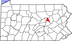
Mechanicsville | |
---|---|
Coordinates: 40°57′58″N76°35′27″W / 40.96611°N 76.59083°W | |
Country | United States |
State | Pennsylvania |
County | Montour |
Area | |
• Total | 2.0 sq mi (5.3 km2) |
• Land | 2.0 sq mi (5.3 km2) |
Population (2000) | |
• Total | 3,099 |
• Density | 1,500/sq mi (580/km2) |
Time zone | UTC-5 (Eastern (EST)) |
• Summer (DST) | UTC-4 (EDT) |
Mechanicsville is a former census-designated place (CDP) in Montour County, Pennsylvania, United States. The population was 3,099 at the 2000 census. It is part of the Bloomsburg-Berwick micropolitan area. As of the 2010 census, Mechanicsville was not listed as a CDP or as any populated place.
Mechanicsville was originally settled by workmen. The Bloomsburg Trolley Line passed through Mechanicsville. A silk mill was built in the community in 1911. [1]
Mechanicsville is located at 40°57′58″N76°35′27″W / 40.96611°N 76.59083°W (40.966240, -76.590781). [2] According to the United States Census Bureau, the CDP has a total area of 2.0 square miles (5.3 km2), all land.
Mechanicsville's terrain is mostly rolling hills. The majority of Mechanicsville's land is residential. [3]
As of the census [4] of 2000, there were 3,099 people, 1,172 households, and 732 families residing in the CDP. The population density was 1,517.4 inhabitants per square mile (585.9/km2). There were 1,236 housing units at an average density of 605.2 per square mile (233.7/km2). The racial makeup of the CDP was 95.03% White, 0.90% African American, 0.03% Native American, 3.10% Asian, 0.45% from other races, and 0.48% from two or more races. Hispanic or Latino of any race were 1.03% of the population.
There were 1,172 households, out of which 27.6% had children under the age of 18 living with them, 51.2% were married couples living together, 9.0% had a female householder with no husband present, and 37.5% were non-families. 35.4% of all households were made up of individuals, and 18.3% had someone living alone who was 65 years of age or older. The average household size was 2.20 and the average family size was 2.85.
In the CDP the population was spread out, with 20.4% under the age of 18, 4.1% from 18 to 24, 21.5% from 25 to 44, 22.3% from 45 to 64, and 31.7% who were 65 years of age or older. The median age was 47 years. For every 100 females, there were 70.8 males. For every 100 females age 18 and over, there were 63.8 males.
The median income for a household in the CDP was $42,750, and the median income for a family was $54,559. Males had a median income of $46,719 versus $31,638 for females. The per capita income for the CDP was $22,528. About 3.2% of families and 9.6% of the population were below the poverty line, including 7.7% of those under age 18 and 20.4% of those age 65 or over.
Charlotte Hall is a census-designated place (CDP) in Charles and St. Mary's counties, Maryland, United States. The population was 1,420 at the 2010 census. The Maryland Veterans Home for disabled veterans, including a U.S. Veterans Affairs clinic, is located on the site of the former Charlotte Hall Military Academy. The Academy site was declared the Charlotte Hall Historic District, and listed on the National Register of Historic Places in 1975. Since 1940, a sizable Amish farming community has existed nearby, along with a farmers' market and large flea market complex on Maryland Route 5, which is also the site of numerous strip-mall businesses continuing into the adjacent community of Mechanicsville.
Aristes is a census-designated place (CDP) in Conyngham Township, Columbia County, Pennsylvania, United States. It is part of Northeastern Pennsylvania. The population was 311 at the 2010 census. It is part of the Bloomsburg-Berwick micropolitan area. Aristes is located adjacent to the famous "ghost town" of Centralia.
Buckhorn is a census-designated place (CDP) in Columbia County, Pennsylvania, United States. It is part of Northeastern Pennsylvania. The population was 318 at the 2010 census. It is part of the Bloomsburg-Berwick micropolitan area. It uses the Bloomsburg ZIP code of 17815.
Fernville is a census-designated place (CDP) in Columbia County, Pennsylvania, United States. It is part of Northeastern Pennsylvania. The population was 556 at the 2010 census. It is part of the Bloomsburg-Berwick micropolitan area.
Foundryville is a census-designated place (CDP) in Columbia County, Pennsylvania, United States. It is part of Northeastern Pennsylvania. The population was 256 at the 2010 census. It is part of the Bloomsburg-Berwick micropolitan area.
Hemlock Township is a township in Columbia County, Pennsylvania. It is part of Northeastern Pennsylvania. As of the 2020 census the population was 2,218, a decline from the figure of 2,249 tabulated in 2010.
Iola is a census-designated place in Columbia County, Pennsylvania, United States. It is part of Northeastern Pennsylvania. The population was 144 at the 2010 census. It is part of the Bloomsburg-Berwick micropolitan area.
Jamison City is a census-designated place in Sugarloaf Township, Columbia County, Pennsylvania, United States. It is part of Northeastern Pennsylvania. The population was 134 at the 2010 census. It is part of the Bloomsburg-Berwick micropolitan area.
Jerseytown is a census-designated place (CDP) that is located in Madison Township, Columbia County, Pennsylvania, United States. It is part of Northeastern Pennsylvania and of the Bloomsburg-Berwick micropolitan area.
Jonestown is a census-designated place (CDP) in Columbia County, Pennsylvania, United States. It is part of Northeastern Pennsylvania. The population was 64 at the 2010 census. It is part of the Bloomsburg-Berwick micropolitan area.
Lightstreet is a census-designated place (CDP) in Columbia County, Pennsylvania, United States. It is part of Northeastern Pennsylvania. The population was 1,093 at the 2010 census. It is part of the Bloomsburg-Berwick micropolitan area. The CDP is named after a street in Baltimore.
Lime Ridge is a census-designated place (CDP) in Columbia County, Pennsylvania, United States. It is part of Northeastern Pennsylvania. The population was 890 at the 2010 census. It is part of the Bloomsburg-Berwick micropolitan area.
Locustdale is a census-designated place (CDP) that is located on the border of Columbia and Schuylkill counties, Pennsylvania, United States. It is part of Northeastern Pennsylvania.
Mainville is a census-designated place in Columbia County, Pennsylvania, United States. It is part of Northeastern Pennsylvania. The population was 132 at the 2010 census. It is part of the Bloomsburg-Berwick micropolitan area.
Mifflinville is an unincorporated community and census-designated place (CDP) in Columbia County, Pennsylvania, United States. It is part of Northeastern Pennsylvania. The population was 1,253 at the 2010 census. It is part of the Bloomsburg-Berwick micropolitan area.
Numidia is a census-designated place (CDP) in Columbia County, Pennsylvania, United States. It is part of Northeastern Pennsylvania. The population was 244 at the 2010 census. It is part of the Bloomsburg-Berwick metropolitan area.
Rohrsburg is a census-designated place (CDP) in Columbia County, Pennsylvania, United States. It is part of Northeastern Pennsylvania. The population was 145 at the 2010 census. It is part of the Bloomsburg-Berwick micropolitan area.
Rupert is a census-designated place (CDP) in Columbia County, Pennsylvania, United States. It is part of Northeastern Pennsylvania. The population was 183 at the 2010 census. It is part of the Bloomsburg-Berwick micropolitan area.
Slabtown is a census-designated place in Columbia County, Pennsylvania, United States. It is part of Northeastern Pennsylvania. The population was 156 at the 2010 census. It is part of the Bloomsburg-Berwick micropolitan area.
Wilburton Number Two is a census-designated place (CDP) in Columbia County, Pennsylvania, United States. It is part of Northeastern Pennsylvania. The population was 96 at the 2010 census. It is part of the Bloomsburg-Berwick micropolitan area.