Bagdogra is a settlement in the Naxalbari CD block in the Siliguri subdivision of the Darjeeling district, in the Indian state of West Bengal. It is a part of the Greater Siliguri Metropolitan Area. Bagdogra is well connected by air to six major cities of India – Delhi, Mumbai, Bengaluru, Hyderabad, Kolkata and Chennai through the Bagdogra Airport. The Bagdogra railway station is also well connected.
Naxalbari is a village in the Naxalbari CD block in the Siliguri subdivision of the Darjeeling district in the state of West Bengal, India. Naxalbari is known for being the site of a 1967 revolt that eventually led to the Naxalite–Maoist insurgency.
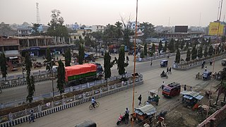
Mechinagar is a municipality in Jhapa District, Koshi Province, Nepal and is the main entry point from India on Nepal's eastern border. Nepal's customs office is in Kakarvitta, a section of the municipality. The city lies 475 km southeast of the capital Kathmandu and 115 km east of Biratnagar, the capital of Province No. 1.

Mahendra Highway, also called East-West Highway, runs across the Terai geographical region of Nepal, from Mechinagar in the east to Bhim Datta in the west, cutting across the entire width of the country. It is the longest highway in Nepal and was constructed in cooperation with various countries. The highway is named after King Mahendra Shah.
Phakphok is a Village in Phakphokthum Rural Municipality of Ilam District in the Koshi Province of eastern Nepal. At the time of the 1991 Nepal census it had a population of 4,233 persons living in 734 individual households.
Lahan (लहान) is a city and municipality in the Siraha district of Madhesh, Nepal. It is the 36th densest municipality in the country, with a population of 102,031 spread out across 24 wards, the most wards of any Nepalese municipality. It is connected with Mahendra Highway, which is also called the east-west highway. It is located nearly 261 km east of the capital, Kathmandu via B.P. highway and E-W Highway and 424 km east via Narayanghat-Mugling Highway. Lahan is located at the latitude of 26.717 and longitude of 86.483. It is at an elevation of 111 meters above sea level. It follows the Nepali time zone, UTC Offset: +05:45 hours.

Baniyani is a Village Development Committee in Jhapa District in the Province No. 1 of south-eastern Nepal. At the time of the 1991 Nepal census it had a population of 5043 people residing in 985 individual households. Laxmi Higher Secondary School, Baniyani Health-Post, and an Armed-Force Camp are located in the vicinity. Mechi River flows to the east on the border of Nepal and India.

Bhadrapur, or Chandragadhi, is a town and municipality in Jhapa District in the Koshi Pradesh of southeastern Nepal. It lies on the banks of the Mechi River and shares borders with Bihar on the south and West Bengal on the north. There is a border crossing with a customs office for goods. Galgalia village in Kishanganj district borders Bhadrapur.
The Kankai River is a trans-boundary river flowing through the hills of Ilam and the plains of the Jhapa District in Nepal. It begins at the confluence of the Mai Khola and Deb Mai Khola rivers.
The Kalapani territory is an area under Indian administration as part of Pithoragarh district in the Kumaon Division of the Uttarakhand state, but it is also claimed by Nepal since 1997. According to Nepal's claim, it lies in Darchula district, Sudurpashchim Province. The territory represents part of the basin of the Kalapani river, one of the headwaters of the Kali River in the Himalayas at an altitude of 3600–5200 meters. The valley of Kalapani, with the Lipulekh Pass at the top, forms the Indian route to Kailash–Manasarovar, an ancient pilgrimage site. It is also the traditional trading route to Tibet for the Bhotiyas of Kumaon and the Tinkar valley of Nepal.

There are several disputed territories of India. A territorial dispute is a disagreement over the possession or control of land between two or more states or over the possession or control of land by a new state and occupying power after it has conquered the land from a former state no longer currently recognized by the new state.

The China–Nepal border is the international boundary between the Tibet Autonomous Region of the People's Republic of China and Federal Democratic Republic of Nepal. It is 1,389 kilometres (863 mi) in length and runs in a northwest–southeast direction along the Himalayan mountain range, including Mount Everest, the world's highest mountain. The boundaries of this particular border have changed dramatically over time, especially when considering relatively recent events such as the Annexation of Tibet in 1949. However, some of the most significant developments of modern times would be the signing of the "Agreement on Maintaining Friendly Relations between the People’s Republic of China and the Kingdom of Nepal" in 1956 and the "Sino-Nepalese Treaty of Peace and Friendship" in 1960, both of which formally recognised Tibet as a part of China and confirmed the limits of the countries of China and Nepal as they are known today.

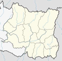
Koshi Province is the autonomous easternmost province adopted on 20 September 2015 by Constitution of Nepal. The province is rich in natural resources, tourist attractions, recreational activities, and natural beauty. The province covers an area of 25,905 km2 (10,002 sq mi), about 17.5% of the country's total area. With the industrial city of Biratnagar as its capital, the province includes major eastern towns of Birtamod, Sundar Haraincha, Damak, Dharan, Itahari, Triyuga Municipality and Mechinagar, and the Mount Everest, Kangchenjunga and Ama Dablam. Koshi River, the largest river of the nation, forms the province's western boundary. Under the First-past-the-post voting system issued by the Constituency Delimitation Commission, Nepal, the province hosts 28 parliamentary seats and 56 provincial assembly seats.
Mikkwakhola is a Gaupalika (Formerly: village development committee) located in Taplejung District in the Mechi Zone of eastern Nepal. The local body was formed by merging four VDCs, namely Khokling, Liwang, Sanwa, Papung. Currently, it has a total of 7 wards. The population of the rural municipality is 9,160 according to the data collected on 2017 Nepalese local elections.
Meringden is a Gaupalika located in Taplejung District in the Mechi Zone of eastern Nepal. The local body was formed by merging five VDCs Thinglabu, Santhakra, Khamlung, Lingtep,Thukima,Nalbu. Currently, it has a total of 6 wards. The population of the rural municipality is 12,548 according to the data collected on 2017 Nepalese local elections.
Sirijangha is a Gaupalika(Nepali: गाउँपालिका ; gaunpalika)(Formerly: village development committee) located in Taplejung District in the Mechi Zone of eastern Nepal. The local body was formed by merging eight VDCs Sinaam, Aambegudin, Sikaicha, Tellok, Pedanga, Mamankhe, Khewang, Yamphudin. Currently, it has a total of 8 wards. The population of the rural municipality is 15,806 according to the data collected on 2017 Nepalese local elections.

The India–Nepal border is an open international boundary running between the republics of India and Nepal. The 1,850 km (1,149.54 mi) long border includes the Himalayan territories as well as Indo-Gangetic Plain of the subcontinent. The current border was delimited after the Sugauli treaty of 1816 between Nepal and the British Raj. Following Indian independence, the prevailing border was recognised as the international border between the Kingdom of Nepal and the Dominion of India.
Batashi is a village in Kharibari CD block in Siliguri subdivision of Darjeeling district of West Bengal, India.
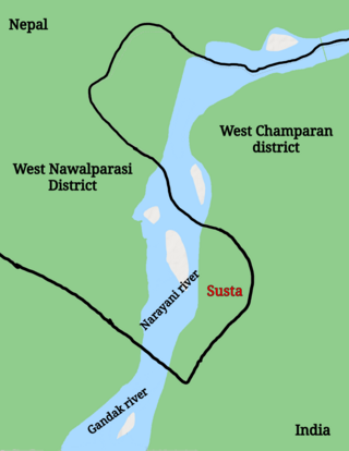
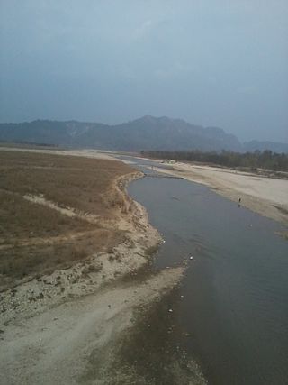
Susta is a disputed territory between Nepal and India. It is administered by India as part of West Champaran district of Bihar. It is claimed by Nepal as part of Susta rural municipality, under West Nawalparasi District in Lumbini Province. The disputed territory is located on the eastern side of the Gandak river. Nepal claims the area a part of West Nawalparasi District under Susta rural municipality, alleging that over 14,860 hectares of Nepali land in Susta has been encroached upon by India while India claims "Susta" to be a part of West Champaran district.

The Mechi Bridge is a bridge that connects Nepal from the Jhapa District to the Darjeeling district in West Bengal, India. Built over Mechi River, this bridge is considered an Eastern Trade point between Nepal and India. It was inaugurated in January 2019.