
The Paleolithic or Palaeolithic, also called the Old Stone Age, is a period in human prehistory that is distinguished by the original development of stone tools, and which represents almost the entire period of human prehistoric technology. It extends from the earliest known use of stone tools by hominins, c. 3.3 million years ago, to the end of the Pleistocene, c. 11,650 cal BP.

National Geographic is an American monthly magazine published by National Geographic Partners. The magazine was founded in 1888 as a scholarly journal, nine months after the establishment of the society, but is now a popular magazine. In 1905, it began including pictures, a style for which it became well-known. Its first color photos appeared in the 1910s. During the Cold War, the magazine committed itself to present a balanced view of the physical and human geography of countries beyond the Iron Curtain. Later, the magazine became outspoken on environmental issues.

An orthophoto, orthophotograph, orthoimage or orthoimagery is an aerial photograph or satellite imagery geometrically corrected ("orthorectified") such that the scale is uniform: the photo or image follows a given map projection. Unlike an uncorrected aerial photograph, an orthophoto can be used to measure true distances, because it is an accurate representation of the Earth's surface, having been adjusted for topographic relief, lens distortion, and camera tilt.
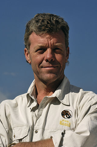
J. Michael Fay is an American ecologist and conservationist notable for, among other things, the MegaTransect, in which he spent 455 days walking 2,000 miles across Africa and the MegaFlyover in which he and pilot Peter Ragg spent months flying 70,000 miles in a small plane at low altitude, taking photographs every twenty seconds. Both projects were sponsored by the National Geographic Society, which produced articles and documentaries about the projects.
MegaTransect was the name for a project conducted in Africa in 1999 by J. Michael Fay to spend 465 days on the expedition hike of 2,000 miles across the Congo Basin of Africa to survey the ecological and environmental status of the region.
ARKive was a global initiative with the mission of "promoting the conservation of the world's threatened species, through the power of wildlife imagery", which it did by locating and gathering films, photographs and audio recordings of the world's species into a centralised digital archive. Its priority was the completion of audio-visual profiles for the c. 17,000 species on the IUCN Red List of Threatened Species.
Chris Johns is a photographer and former editor-in-chief for National Geographic Magazine, a role he held from January 2005 to April 2014. After an internal reorganization at the organization, in April 2014, Johns was named chief content officer of National Geographic Society. He spent many years in Africa for the magazine and is the first photographer to have been named its editor-in-chief. He started his journalism career at daily newspapers.

Candor Chasma is one of the largest canyons in the Valles Marineris canyon system on Mars. The feature is geographically divided into two halves: East and West Candor Chasmas, respectively. It is unclear how the canyon originally formed; one theory is that it was expanded and deepened by tectonic processes similar to a graben, while another suggests that it was formed by subsurface water erosion similar to a karst. MRO discovered sulfates, hydrated sulfates, and iron oxides in Candor Chasma.

Eve's footprint is the popular name for a set of fossilised footprints discovered on the shore of Langebaan Lagoon, South Africa in 1995. They are thought to be those of a female human and have been dated to approximately 117,000 years ago. This makes them the oldest known footprints of an anatomically-modern human. The estimated age of Eve's footprint means that the individual who left the tracks in the soil, thought to be female, would have lived within the current wide range of estimates for the date of Mitochondrial Eve.
The following is a timeline of the history of the city of Nairobi, Kenya.
The following is a historical events of Addis Ababa, the capital of Ethiopia, including its formation prior to 20th century by chronology.
The following is a timeline of the history of the city of Johannesburg, in the Gauteng province in South Africa.
The following is a timeline of the history of the city of Lusaka, Zambia.
The following is a timeline of the history of the city of Accra, Ghana.
Yarnell is an unincorporated historic locale in Lane County, Oregon, United States. It was located about 5 miles south of Mohawk, in the Mohawk Valley.

Vadapalani is an elevated metro station on the South-East Corridor of the Green Line of Chennai Metro in Chennai, India. This station serves the neighbourhoods of Vadapalani and Kodambakkam and is one of the major stations on the Koyambedu-Alandur stretch and became operational by early 2015.
Chennai is home to the second largest vehicular population in India, behind New Delhi. The total road network in the city's metropolitan area is 2,780 km. With Chennai's vehicular population having experienced a surge in the late 1990s, several flyovers were built to reduce the traffic congestion in the city. Of about ₹ 15,600 million invested by the state government between 2005 and 2016, Chennai cornered a major chunk of the investment. As of 2016, there were 42 functional flyovers in the city and about 30 bridges, catering to the city's vehicular population of about 12 million, including about 600,000 cars. In addition, more than 36 flyovers are in the pipeline.
Pete Oxford is a British-born conservation photographer based in Quito, Ecuador. Originally trained as a marine biologist, he and his wife, South African-born Reneé Bish, now work as a professional photographic team focusing primarily on wildlife and indigenous cultures.
The following is a timeline of the history of the city of Windhoek, Namibia.
The following is a timeline of the history of the city of Bujumbura, Burundi.