MegaTransect

Last updated

MegaTransect was the name for a project conducted in Africa in 1999 by J. Michael Fay to spend 465 days on the expedition hike of 2,000 miles (3,219 kilometers) across the Congo Basin of Africa to survey the ecological and environmental status of the region.

Contents

A transect is a term in ecology that denotes a survey of the natural vegetation through a particular area. The concept of a megatransect was conceived as a vegetation transect on a large scale that could be used to take an ecological census of the natural vegetation and ecosystems.

Shortly after the hike, Fay successfully lobbied alongside the President of Gabon to create 13 new national parks. In 2002, US Secretary of State Colin Powell and other Bush Administration members gave 53 million dollars to help preserve the Congo Basin.[ citation needed ]

Mike Fay later went on to carry out the MegaFlyover in 2004.

Madagascar megatransect

Also in 2004, an international team conducted a "Megatransect" of the island of Madagascar. Dubbed "Hike Madagascar", the journey covered the entire island. Members met with rural farmers to help them improve their agricultural techniques and discuss their impact on the environment.

History of US megatransects

One of the first megatransects in the United States was conducted by Dr. Robert R. Humphrey when he rephotographed 535 miles of the natural vegetation along with the United States and Mexico border at the 1890s permanent border monument locations, each spaced about five miles apart, and published this work in 90 Years and 535 Miles: Vegetation Changes Along the Mexican Border (1987, pub. Univ. of NM Press, 448 pages).

In 1997 Craig C. Dremann conducted a megatransect surveying over 3,000 miles and at each mile-marker, noting the roadside vegetation, the perennial native grass, and exotic grass status throughout the Great Basin ecosystem. The route was from Reno, Nevada eastward to Hot Springs, South Dakota, and from South Dakota through Wyoming, Idaho, Nevada, and California, returning westward to Bishop, California, and then north back to Reno.[ citation needed ]

In 2005, Dremann conducted another vegetation megatransect, this time of the California portion of the Mojave desert, mapping over 1,000 miles on a mile-by-mile basis, for a fast-spreading exotic mustard species, Brassica tournefortii, noting the locations and density of the Mojave desert Mustard infestation in California.[ citation needed ]

Dremann suggests that a method of remotely conducting a large-scale vegetation megatransect is with photographs. Photographs that have been taken at ground-level at intervals from known locations can be stitched together to create large-scale to Continent-scale megatransect pictures of ecosystems.

In 2006, Dr. Michael C. McGrann and his wife Amy M. McGrann hiked the length of the California section of Pacific Crest National Scenic Trail (PCT) in the western United States from Mexico to the Oregon border (2,736 km) while systematically collecting avian-habitat data on 3,578 survey plots separated by 10-minute hiking intervals. This work was completed in a single field season from 2 April to 8 September. From this data, Dr. McGrann and his collaborators described the elevation and latitudinal distributions of birds along the PCT [1] and statistically modeled avian species richness relationships with elevation, climate, and environmental factors including temperature, precipitation, and primary productivity. [2] The results from this work showed that birds can exhibit heterogeneous relationships to temperature, precipitation, and productivity depending on the distinct environmental and climate conditions of each of the ecological regions traversed by the PCT. [3] The PCT megatransect is an ongoing research project for Dr. McGrann in collaboration with several other researchers. He has continued his biodiversity surveys along sections of the PCT in 2007, 2010, and 2015, and he is working both to expand taxa surveyed along the PCT and to involve his undergraduate students at William Jessup University in the PCT Mega-Transect.

In 2007–2008 J. Michael Fay and Lindsey Holm completed a 1300-mile Redwood Transect of 333 days. This was a megatransect that spanned from the southernmost to the northernmost redwood trees in California and Oregon. They walked extensively on private timberland and public land recording data on historical exploitation, current forest stand characteristics, silviculture, and many other aspects of the redwood ecosystem. The results will be published in National Geographic in 2009.[ citation needed ]

The Appalachian Trail Conservancy and the National Park Service are adopting the idea of a megatransect for the Appalachian Trail (A.T.) Like other megatransects, the A.T. MEGA-Transect aims to monitor the natural resources along the trail, understand the status and trends of these resources, and inform and engage the public and stakeholders. The 2,178-mile-long trail crosses 14 states, from Georgia to Maine, and is visited by one to two million people and completed by about 400 people each year. Volunteer citizen scientists are beginning to implement monitoring protocols to track natural resources such as wildlife presence, water quality, forest health, invasive plants, endangered species, mountain birds, phenology, and air quality. Professional scientists are also using the transect for independent research. The A.T. is oriented along the predicted migratory direction of species responding to climate change, making it a particularly important megatransect to establish and maintain.

MegaTransect future

For a rapidly changing planet, megatransects establish baseline data from which to draw future trends, and they can focus attention on particular ecosystems which are disappearing faster than others.

Establishing standard megatransects on specific regions or through various ecosystems of each continent, and periodic remeasurement of the ecological conditions along routes, every five to ten years, would provide very valuable measured data on environmental trends.

See also

Related Research Articles

<span class="mw-page-title-main">Geography of California</span>

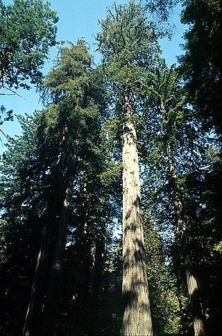
California is a U.S. state on the western coast of North America. Covering an area of 163,696 sq mi (423,970 km2), California is among the most geographically diverse states. The Sierra Nevada, the fertile farmlands of the Central Valley, and the arid Mojave Desert of the south are some of the major geographic features of this U.S. state. It is home to some of the world's most exceptional trees: the tallest, most massive, and oldest. It is also home to both the highest and lowest points in the 48 contiguous states. The state is generally divided into Northern and Southern California, although the boundary between the two is not well defined. San Francisco is decidedly a Northern California city and Los Angeles likewise a Southern California one, but areas in between do not often share their confidence in geographic identity. The US Geological Survey defines the geographic center of the state at a point near North Fork, California.

<span class="mw-page-title-main">Pacific Crest Trail</span> Long-distance hiking and equestrian trail in the western US

The Pacific Crest Trail (PCT), officially designated as the Pacific Crest National Scenic Trail, is a long-distance hiking and equestrian trail closely aligned with the highest portion of the Cascade and Sierra Nevada mountain ranges, which lie 100 to 150 miles east of the U.S. Pacific coast. The trail's southern terminus is next to the Mexico–United States border, just south of Campo, California, and its northern terminus is on the Canada–US border, upon which it continues unofficially to the Windy Joe Trail within Manning Park in British Columbia; it passes through the states of California, Oregon, and Washington.

<span class="mw-page-title-main">San Gabriel Mountains</span> Mountain range of the Transverse Ranges in California, United States

The San Gabriel Mountains are a mountain range located in northern Los Angeles County and western San Bernardino County, California, United States. The mountain range is part of the Transverse Ranges and lies between the Los Angeles Basin and the Mojave Desert, with Interstate 5 to the west and Interstate 15 to the east. The range lies in, and is surrounded by, the Angeles and San Bernardino National Forests, with the San Andreas Fault as its northern border.

<span class="mw-page-title-main">Big Basin Redwoods State Park</span> State park in Santa Cruz County, California, United States

Big Basin Redwoods State Park is a state park in the U.S. state of California, located in Santa Cruz County, about 36 km (22 mi) northwest of Santa Cruz. The park contains almost all of the Waddell Creek watershed, which was formed by the seismic uplift of its rim, and the erosion of its center by the many streams in its bowl-shaped depression.

<span class="mw-page-title-main">Ecology of California</span> Environments and natural history of California

The ecology of California can be understood by dividing the state into a number of ecoregions, which contain distinct ecological communities of plants and animals in a contiguous region. The ecoregions of California can be grouped into four major groups: desert ecoregions, Mediterranean ecoregions, forested mountains, and coastal forests.

<span class="mw-page-title-main">San Bernardino Valley</span> Valley in California, United States

The San Bernardino Valley is a valley in Southern California located at the south base of the Transverse Ranges. It is bordered on the north by the eastern San Gabriel Mountains and the San Bernardino Mountains; on the east by the San Jacinto Mountains; on the south by the Temescal Mountains and Santa Ana Mountains; and on the west by the Pomona Valley. Elevation varies from 590 feet (180 m) on valley floors near Chino to 1,380 feet (420 m) near San Bernardino and Redlands. The valley floor is home to over 80% of the more than 4 million people in the Inland Empire region.

<span class="mw-page-title-main">Owens Peak Wilderness</span> Protected wilderness area in California, United States

The Owens Peak Wilderness is a 73,767-acre (298.52 km2) wilderness area comprising the rugged eastern face of the Sierra Nevada. Owens Peak (8,445 ft) is the high point. The land was set aside with the passage of the California Desert Protection Act of 1994 by the US Congress.

<i>Holocarpha macradenia</i> Species of flowering plant

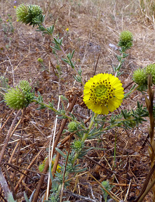
Holocarpha macradenia, commonly known as the Santa Cruz tarplant, is an endangered plant endemic to Northern California. Alternative common names for this plant are Santa Cruz tarweed or Santa Cruz sunflower.

<span class="mw-page-title-main">Prairie Creek Redwoods State Park</span> State park in Humboldt County, California, United States

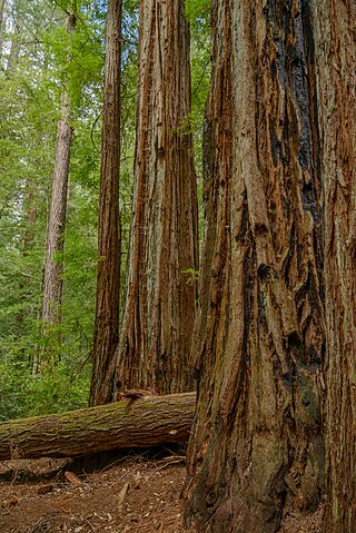
Prairie Creek Redwoods State Park is a state park, located in Humboldt County, California, near the town of Orick and 50 miles (80 km) north of Eureka. The 14,000 acre (57 km²) park is a coastal sanctuary for old-growth Coast Redwood trees.

<span class="mw-page-title-main">Turnbull National Wildlife Refuge</span>

The Turnbull National Wildlife Refuge is located six miles (10 km) south of Cheney, Washington, on the eastern edge of the Columbia Basin in Spokane County in northeastern Washington. Turnbull NWR encompasses more than 18,000 acres (7,300 ha) of the Channeled Scablands. The ecosystem that predominates the refuge is unique within the National Wildlife Refuge System and has characteristics that distinguish it from natural reserves worldwide. The combination of basalt outcrops, channeled canyons, and ponderosa pine forests infused in a diverse landscape of over 130 marshes, wetlands, and lakes creates an environment of aesthetic beauty as well as high quality wildlife habitat. The refuge is named for Cyrus Turnbull who lived on the site in the 1880s.

<span class="mw-page-title-main">Kiavah Wilderness</span> Protected wilderness area in California, United States

The Kiavah Wilderness is a federally designated wilderness area located in the Mojave Desert, Scodie Mountains, and southern Sierra Nevada in Kern County, California, United States. California State Route 178 connects the town of Lake Isabella to State Highway 14 in the east, crossing Walker Pass at the north boundary of the wilderness.

<span class="mw-page-title-main">Joshua Tree National Park</span> National park in California, United States

Joshua Tree National Park is an American national park in southeastern California, east of San Bernardino and Los Angeles and north of Palm Springs. It is named after the Joshua trees native to the Mojave Desert. Originally declared a national monument in 1936, Joshua Tree was redesignated as a national park in 1994 when the U.S. Congress passed the California Desert Protection Act. Encompassing a total of 795,156 acres – slightly larger than the state of Rhode Island – the park includes 429,690 acres of designated wilderness. Straddling San Bernardino and Riverside Counties, the park includes parts of two deserts, each an ecosystem whose characteristics are determined primarily by elevation: the higher Mojave Desert and the lower Colorado Desert. The Little San Bernardino Mountains traverse the southwest edge of the park.

<span class="mw-page-title-main">San Elijo Lagoon</span> Coastal wetland in San Diego County, California, United States

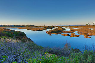
San Elijo Lagoon Ecological Reserve is one of the largest remaining coastal wetlands in San Diego County, California, United States.

<span class="mw-page-title-main">Adobe Creek (Santa Clara County)</span> Stream in Santa Clara County, California

Adobe Creek, historically San Antonio Creek, is a 14.2-mile-long (22.9 km) northward-flowing stream originating on Black Mountain in the Santa Cruz Mountains. It courses through the cities of Los Altos Hills, Los Altos, and Palo Alto on its way to the Palo Alto Flood Basin and thence to southwestern San Francisco Bay in Santa Clara County, California, United States. Historically, Adobe Creek was a perennial stream and hosted runs of steelhead trout entering from the Bay, but these salmonids are now blocked by numerous flood control structures, including a tidal gate at the creek's mouth and a long concretized rectangular channel culminating in an impassable drop structure at El Camino Real. The co-founders of Adobe Systems both lived on Adobe Creek.

<span class="mw-page-title-main">Little Zigzag River</span> River in Oregon, United States

The Little Zigzag River is a tributary, about 5 miles (8.0 km) long, of the Zigzag River in the U.S. state of Oregon. The Zigzag and Little Zigzag drain the Zigzag Glacier on Mount Hood, a high volcanic peak in the Cascade Range. Their combined waters flow westward to meet the Sandy River near the community of Zigzag. Little Zigzag Falls, a popular hiking destination, is on the river near U.S. Route 26 east of Zigzag.

<span class="mw-page-title-main">Arastradero Creek</span> River in California, United States

Arastradero Creek is a mainly seasonal 2.4-mile-long (3.9 km) generally north by northeastward-flowing stream originating in the Palo Alto foothills of the Santa Cruz Mountains in Santa Clara County, California, United States. It is almost wholly protected by the Pearson–Arastradero Preserve, before joining Matadero Creek where its waters descend to San Francisco Bay.

<span class="mw-page-title-main">Tahoe–Yosemite Trail</span>

The Tahoe–Yosemite Trail (TYT) is a long-distance trail in the Sierra Nevada mountain range of California. The trail courses 186 miles (299 km) from Meeks Bay at Lake Tahoe to Tuolumne Meadows in Yosemite National Park. The trail is a foot and equestrian path that passes through the Desolation, Mokelumne, Carson-Iceberg, Emigrant, and Yosemite Wilderness Areas and the Meiss Country (Dardanelles) Roadless Area.

The Southern Redwood Botanical Area is a 17 acres (6.9 ha) ecological preserve in the southern region of Big Sur in Monterey County, California, just north of the national forest's Salmon Creek trailhead. Established by the Los Padres National Forest of the United States Forest Service, it contains the southernmost naturally occurring Redwood. The trees are located in the Little Redwood Gulch watershed adjacent to the Silver Peak Wilderness. The area is just north of the Salmon Creek trailhead.

<span class="mw-page-title-main">National parks in California</span> National parks in California

There are nine national parks located in the state of California managed by the National Park Service. National parks protect significant scenic areas and nature reserves, provide educational programs, community service opportunities, and are an important part of conservation efforts in the United States. There are several other locations inside of California managed by the National Park Service, but carry other designations such as National Monuments. Many of the national parks in California are also part of national forests and National Wildlife Refuges, and contain Native American Heritage Sites and National Monuments.

Mission Creek Preserve is a Wildlands Conservancy nature preserve consisting of 4,760 acres (19.3 km2) of land in Riverside County, California west of Morongo Valley. Perennial Mission Creek flows through a desert canyon. The preserve is located within the San Bernardino Mountains and is part of the Sand to Snow National Monument.

References

  1. McGrann, Michael; Thorne, James (2014). "Elevational ranges of birds along California's Pacific Crest Trail". Western Birds. 45: 18–42.
  2. McGrann, Michael; Tingley, Morgan; Elliott-Fisk, Deborah; Thorne, James; McGrann, Amy (2014). "Heterogeneity in avian richness-environment relationships along the Pacific Crest Trail". Avian Conservation and Ecology. 9 (2): 8.
  3. McGrann, Michael; Thorne, James (2014). "Elevational ranges of birds along California's Pacific Crest Trail". Western Birds. 45: 18–42.