
The Hornisgrinde, 1,164 m (3,820 ft), is the highest mountain in the Northern Black Forest of Germany. The Hornisgrinde lies in northern Ortenaukreis district.
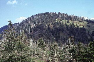
Clingmans Dome is a mountain in the Great Smoky Mountains of Tennessee and North Carolina, in the southeastern United States. At an elevation of 6,643 feet (2,025 m), it is the highest mountain in the Smokies, the highest point in the state of Tennessee, and the highest point along the 2,174-mile (3,499 km) Appalachian Trail. It is also the third highest point in mainland Eastern North America, after the nearby Mount Mitchell and Mount Craig.

Hunter Mountain is in the towns of Hunter and Lexington, just south of the village of Hunter, in Greene County, New York, United States. At approximately 4,040 feet (1,231 m) in elevation, it is the highest peak in the county and the second-highest peak in the Catskill Mountains.

Klínovec is the highest peak of the Ore Mountains, located in the Czech Republic's part of the mountains at 1,244 metres (4,081 ft). There is an important TV broadcasting tower on the top of the mountain.
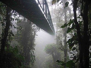
Canopy walkways - also called canopy walks, treetop walks or treetop walkways - provide pedestrian access to a forest canopy. Early walkways consisted of bridges between trees in the canopy of a forest; mostly linked up with platforms inside or around the trees. They were originally intended as access to the upper regions of ancient forests for scientists conducting canopy research. Eventually, because they provided only limited, one-dimensional access to the trees, they were abandoned for canopy cranes. Today they serve as ecotourism attractions in places such as Dhlinza Forest, KwaZulu-Natal, South Africa, Taman Negara National Park, Malaysia, Sedim River, Kulim, Nyungwe National Park, Rwanda and Kakum National Park, Ghana.
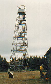
The Hunter Mountain Fire Tower is located on the summit of the eponymous mountain, second highest of the Catskill Mountains in the U.S. state of New York. It was the first of 23 fire lookout towers built by the state in the region, and the next-to-last of the five still standing to be abandoned.

Sainte-Foy-Tarentaise is a commune in the Savoie department in the Auvergne-Rhône-Alpes region in south-eastern France.

The Schwarzwaldhochstraße, or "Black Forest High Road", is the oldest, and one of the best known, themed drives in Germany. It is a part of the B 500 federal highway.

Bickle Knob is a mountain summit located east of Elkins in Randolph County, West Virginia, USA. Easily accessible during warm-weather months, Bickle Knob is also home to one of the few remaining observation towers in Monongahela National Forest.

The Brandenkopf is 945.2 m above sea level (NHN) and one of the highest mountains in the Central Black Forest in southern Germany. The mountain lies in the county of Ortenaukreis in the state of Baden-Württemberg within the municipalities of Oberharmersbach, Fischerbach and Hausach, its summit is part of Oberharmersbach. The mountain forms the prominent centrepiece between the valleys of the Kinzig, the Wolf and the Harmersbach.

The Hochfirst is a wooded mountain between Saig and Titisee-Neustadt in the Black Forest in Germany with a height of 1,190.1 m above sea level (NHN).

The Hohe Möhr is a mountain, 983.6 m above sea level (NHN), in the Black Forest near Schopfheim in the German state of Baden-Württemberg.

The Moos is a mountain range in the Central Black Forest in southern Germany. Its highest points are the Siedigkopf and the Mooskopf, actually the Geisschleifkopf. The Moos is the local mountain or Hausberg of Gengenbach and Oppenau.

The Stöcklewald is a mountain, 1,068.2 m above sea level (NHN), in the southern part of the Central Black Forest in Germany between the towns of Furtwangen and Triberg, each about 5 kilometres distant, in the county of Schwarzwald-Baar-Kreis. Towards the north, the Black Forest only exceeds this height again in the area of the Schliffkopf and the Hornisgrinde.

Raichberg is a mountain of Baden-Württemberg, Germany, with an elevation of 956 meters (3,136 ft) above sea level. It is located in Zollernalbkreis close to the northwestern edge of the Schwäbische 'Alb'.

The Geißkopf is a mountain, 1,097.4 m above sea level (NHN), in the Bavarian Forest in Germany.

The Blättersberg near Rhodt unter Rietburg in the Rhenish-Palatine county of Südliche Weinstraße is a mountain, 613.2 m above sea level (NHN), in the Palatine Forest in the German state of Rhineland-Palatinate.

The Bingen Forest is part of the Hunsrück, a low mountain range in the Central Uplands of Germany. It is up to 638.6 m above sea level (NN) and is located in the state of Rhineland-Palatinate.

The Hoher Ochsenkopf is a mountain in the Northern Black Forest in the municipality of Forbach in south Germany. At 1,054.5 m above sea level (NHN) it is the highest point in Forbach and also in the county of Rastatt. The mountain, whose domed summit or kuppe was already a nature reserve lies in the Black Forest National Park which was founded in 2014. Its name recalls its former use as wood pasture.

The Hochkopf is a mountain in the county of Rastatt in the Black Forest in Germany with height of 1,038.3 m above sea level (NHN). It is located northeast of the nearby Hornisgrinde, the highest mountain of the Northern Black Forest. About 700 metres away to the north, as part of the same mountain ridge, is the Pfrimmackerkopf. The plateau with its semi-protected forest or Schonwald, is a grinde, an open highland landscape typical of the Northern Black Forest, and is part of the Bühlertal conservation area.


