The City of Maribyrnong is a local government area within the metropolitan area of Melbourne, Australia. It comprises the inner western suburbs between 5 and 10 kilometres from Melbourne city centre. It was formed in 1994 from the merger of the City of Footscray and parts of the City of Sunshine. In June 2018, Maribyrnong had a population of 91,387.

Maribyrnong is an inner-city suburb in Melbourne, Victoria, Australia, 8 km (5.0 mi) north-west of Melbourne's Central Business District, located within the City of Maribyrnong local government area. Maribyrnong recorded a population of 12,573 at the 2021 census.

The Maribyrnong River is a perennial river of the Port Phillip catchment, located in the north–western suburbs of Melbourne, in the Australian state of Victoria.

Braybrook is a suburb in Melbourne, Victoria, Australia, 10 km (6.2 mi) west of Melbourne's Central Business District, located within the City of Maribyrnong local government area. Braybrook recorded a population of 9,682 at the 2021 census.

Footscray is an inner-city suburb in Melbourne, Victoria, Australia, 5 km (3.1 mi) west of Melbourne's Central Business District, located within the City of Maribyrnong local government area. Footscray recorded a population of 17,131 at the 2021 census.
Maidstone is a suburb in Melbourne, Victoria, Australia, 8 km (5.0 mi) north-west of Melbourne's Central Business District, located with the City of Maribyrnong local government area. Maidstone recorded a population of 9,389 at the 2021 census.

Seddon is an inner-city suburb in Melbourne, Victoria, Australia, 7 km (4.3 mi) west of Melbourne's Central Business District, located within the City of Maribyrnong local government area. Seddon recorded a population of 5,143 at the 2021 census.

Yarraville is an inner-city suburb in Melbourne, Victoria, Australia, 6 km (3.7 mi) west of Melbourne's Central Business District, located within the City of Maribyrnong local government area. Yarraville recorded a population of 15,636 at the 2021 census.

The Moonee Ponds Creek Trail is a shared use path for cyclists and pedestrians, which follows the Moonee Ponds Creek through the northern suburbs of Melbourne, Victoria, Australia.

The Maribyrnong River Trail is a shared use path for cyclists and pedestrians, which follows the Maribyrnong River through the north western suburbs of Melbourne, Victoria, Australia.

The Division of Maribyrnong is an Australian electoral division in the state of Victoria. It is located in the inner north-western suburbs of Melbourne. Suburbs include Aberfeldie, Airport West, Avondale Heights, Essendon, Footscray, Gowanbrae, Keilor East, Maribyrnong, Moonee Ponds, Niddrie, West Footscray and Tullamarine. Due to redistributions, the division has been slowly moving west and changed with the introduction of the Division of Fraser in 2018. According to the 2011 census, Maribyrnong has the highest proportion of Catholics in any Commonwealth Electoral Division in Australia with 41.6% of the population.

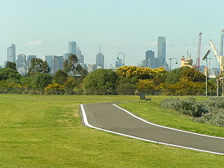
Melbourne is Australia's second largest city and widely considered to be a garden city, with Victoria being nicknamed "the Garden State". Renowned as one of the most livable cities in the world, there is an abundance of parks, gardens and green belts close to the CBD with a variety of common and rare plant species amid landscaped vistas, pedestrian pathways, and tree-lined avenues, all managed by Parks Victoria.

Footscray Park is one of the largest and most intact examples of an Edwardian park in Australia. The 15-hectare park is located on the south bank of the Maribyrnong River in Footscray in Victoria. It is classified as a heritage place on the Victorian Heritage Register for its aesthetic, horticultural and social significance to the State of Victoria and was the first gardens to be placed on the register. The park is noted for its botanical collection, ornamental ponds and garden structures.
The Hobsons Bay Coastal Trail is a shared use path for cyclists and pedestrians, which follows the coast line of Hobsons Bay in the inner western suburbs in Melbourne, Victoria, Australia. The trail forms part of the western half of the Bayside Trail which encircles Port Phillip. It runs from the west side of the Westgate bridge, south and along the coast, finishing at the Skeleton Creek Trail in Sanctuary Lakes.

The City of Footscray was a local government area about 5 kilometres (3 mi) west of Melbourne, the state capital of Victoria, Australia. The city covered an area of 17.10 square kilometres (6.60 sq mi) and existed from 1859 until 1994. Its civic centre, after which it was named, was Footscray.

The Chinese Museum or Museum of Chinese Australian History is an Australian history museum located in Melbourne's Chinatown, which is dedicated to documenting, preserving and displaying the history, heritage and culture of Australia's Chinese community. The museum was established in 1985 with a charter to present the history of Australians of Chinese ancestry. An extensive refurbishment funded by the Victorian Government was completed in 2010. Since then, the museum has also acted as a Chinatown Visitor Centre.

Janet Elizabeth Rice is an Australian politician. She is a member of the Australian Greens and has served as a Senator for Victoria since 2014. She was a co-founder of the Victorian Greens and also served on the Maribyrnong City Council from 2003 to 2008, including a term as mayor.
MREAM is the Maribyrnong River Edge Art Movement, established in 1988 by a co-operative of Western Suburbs of Melbourne artists. MREAM obtained the use of a disused industrial building from the City of Footscray which had been compulsorily acquired as part a proposed urban renewal project on the banks of the Maribyrnong River. The group produced its first guide to studio spaces and
Pipemakers Park is located in the inner western suburbs of Melbourne in the city of Maribyrnong, on the western bank of the Maribyrnong River near Highpoint Shopping Centre. The park was created on the site of a former pipe works and meat preserving company, and retains historic buildings adapted to a museum. and interpreted industrial ruins.

