Membley Estate Ruiru

Last updated

Membley
Membley Estate Ruiru.jpg
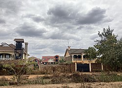
Residential Houses in Membley Estate in Ruiru, Kenya
Kenya adm location map.svg
Red pog.svg
Membley
Coordinates: 1°09′47″S36°55′43″E / 1.163075°S 36.928708°E / -1.163075; 36.928708 Coordinates: 1°09′47″S36°55′43″E / 1.163075°S 36.928708°E / -1.163075; 36.928708
CountryFlag of Kenya.svg  Kenya
District Thika District
LocalityRuiru Municipality
Division Ruiru
Constituency Ruiru
Established2000

Membley Estate is an upper middle-class suburb located near Nairobi, in the South-Western Ruiru Municipal area of Kiambu County. The suburb is located a short distance from Kenyatta University, Kamakis and Tatu City some 1.5 Kilometers from the Thika Road. The Membley Baptist, St. Lucia Catholic Church and ACK St Mathew's Membley Churches are found within this locality.

Contents

Administration

Membley falls within the Ruiru Municipality Area (chartered in 2018) [1] and hitherto the Nairobi Metropolitan Area. [2] Administratively, the area falls within the Gitothua electoral ward of Ruiru Constituency, Kiambu County. The area is also domiciled within what was formerly Thika District. [3]

Education

Educational institutions within the estate include Danjose Academy, Focus Academy, Top Talents Academy, St. Beautah School, Fine Care Kindergarten, and Membley High School.

Transport

Membley is served by the Nairobi Eastern Bypass Highway, Nairobi Northern Bypass Highway, and Thika Road.

Membley Estate Pano.jpg
Wide View Photo of Membley Estate

Related Research Articles

<span class="mw-page-title-main">Thika</span> Municipality in Kiambu County, Kenya

Thika is an industrial town and a major commerce hub in Kiambu County, Kenya, lying on the A2 road 42 kilometres (26 mi), Northeast of Nairobi, near the confluence of the Thika and Chania Rivers. Although Thika town is administratively in Kiambu County, the greater Thika area comprising such residential areas such as Bendor estate, Maporomoko, Thika Greens, Thika Golden Pearl, Bahati Ridge, Thika Sports Club, among others, are within Murang'a County. Thika has a population of 279,429 which is growing rapidly, as is the entire greater Nairobi area. Its elevation is approximately 1,631 metres (5,351 ft).

<span class="mw-page-title-main">Ruiru</span> Urban Area in Kiambu County, Kenya

Ruiru is a municipality and sub-county in Kiambu County. It sits within the greater Nairobi Metropolitan region. According to the 2019 national population census, Ruiru is the 4th largest urban centre in Kenya by population. The name Ruiru is of the Kikuyu dialect and possibly relates to the black cotton soil that is found in most parts of Ruiru to the East and South.

Kiambu is a town in Kiambu County, Kenya within the Nairobi Metropolitan Region. It is 14 km (8.7 mi) from the capital Nairobi. It has a population of 147,870. It is the capital of the Kiambu County, which bounds the northern border of Nairobi. Other proximate towns are Ruiru, Gatundu (NE), Limuru (NW) and Kabete (SW).

<span class="mw-page-title-main">Kiambu County</span> Place in Kenya

Kiambu County is a county in the former Central Province of Kenya. Its capital is Kiambu and its largest town is Thika. Kiambu County is the second most populous after Nairobi County. Kiambu County borders Nairobi and Kajiado Counties to the South, Machakos to the East, Murang'a to the North and North East, Nyandarua to the North West, and Nakuru to the West and has a population of 2,417,735.

<span class="mw-page-title-main">Gatundu</span> Township in Kiambu County, Kenya

Gatundu is a small town in Kiambu County of Kenya. It is known for the first Kenyan president Jomo Kenyatta who lived about three kilometres away from the town, as well as his son, Uhuru Kenyatta, now the 4th President of Kenya and former Member of Parliament representing Gatundu South Constituency. The town is located on a hill surrounded by many farms and residences.

Kahawa is a mixed-use settlement spanning the Kiambu County and Nairobi County borders along Thika Road. It is electorally divided into four wards across the two counties: Kahawa and Kahawa West wards in Nairobi county and Kahawa Wendani and Kahawa Sukari wards in Kiambu county. Despite its proximity to the city, half of it is administratively in Ruiru, while some parts, such as Kenyatta University, Kahawa Barracks, Kiwanja and Githurai 44, are administratively in Kasarani.

Ituru is a settlement in Kenya's Central Province. It is in Gatundu South constituency, Kiambu County. Proximate towns are Gatundu (south), Ruiru and Juja. Other villages neighbouring Ituru includes, Giathi, Gaithece, Gitundu, Itwiku, Muthurumbi, Giathi and Kagumoini.

<span class="mw-page-title-main">Kamulu</span> Place in Kenya

Kamulu is an informal settlement located 30.5 kilometres (19.0 mi) from Nairobi central business district(CBD). It borders Joska, Matungulu to the east, Mwalimu Farm, Ruiru to the north, Njiru to the west and Mihang'o to the south west.

<span class="mw-page-title-main">Githurai</span> Place in Nairobi County & Kiambu County, Kenya

Githurai is a composition of densely populated, urban, mixed-use settlements located at the border of Nairobi County and Kiambu County along the Thika Road. Githurai is divided into two; Githurai 45 and Githurai 44. Githurai 45 falls under Ruiru Constituency in the Githurai Sub-county of Kiambu County with the boundary being the Thika Road reserve and River Kasarani downstream. Githurai 44 is domiciled in Roysambu Constituency in the Kasarani Sub-county of Nairobi County. Githurai 44 neighbours Kahawa West, Zimmerman and Njatha-ini Village.

<span class="mw-page-title-main">Thika Road</span>

Thika Road is an 8-lane controlled-access highway in Kenya, with 12 lanes in some sections. It links the capital city of Nairobi with the industrial town of Thika. The Thika Road forms 50 km of the A2 Highway, which is part of the Cape to Cairo Road. In Kenya, it links Namanga at the Tanzania-Kenya border to the Kenya-Ethiopia border town of Moyale.

<span class="mw-page-title-main">Juja</span>

Juja is a town in Kiambu County in Kenya. It is the home town for Jomo Kenyatta University of Agriculture and Technology (JKUAT). It is also a constituency in Kiambu county, currently represented in parliament by Hon. George Koimburi following the demise of the late Hon. Francis Munyua Waititu. The MCA is Kalpesh Jayantilal Shah, who represents the people of Juja Ward at the County Government.

Lizzie Muthoka Wanyoike,, is a Kenyan businesswoman, entrepreneur, educator and philanthropist, who is the founder and chief executive officer of the Nairobi Institute of Business Studies (NIBS).

The Nairobi Eastern Bypass Highway is a road in Kenya, forming a semi-circle through the south-eastern and north-eastern neighbourhoods of the capital city of Nairobi. The road allows traffic from Mombasa, destined for the central parts of Kenya to bypass downtown Nairobi, thereby reducing traffic congestion in the city's central business district.

Nairobi Northern Bypass Highway is a road in Kenya, the largest economy in the East African Community. It connects the neighbourhood of Ruaka to the neighborhood of Ruiru, both in Kiambu County.

Tatu City is a 5,000 acres (2,000 ha) special economic zone (SEZ) located 20 kilometres (12 mi) North of Nairobi Central Business District (CBD) in the Ruiru Municipality area of Kiambu County. It sits within the greater Nairobi Metropolitan region and is a flagship project of the Kenya Vision 2030 blueprint.

Mwiki is a low-income neighbourhood in the counties of Nairobi and Kiambu. It is approximately 14 kilometres (8.7 mi) northeast of the central business district of Nairobi. Due to its transregional nature, the part of Mwiki that is within Nairobi is referred as Kasarani Mwiki while the other portion domiciled in Kiambu is referred as Githurai Mwiki.

Kamakis is an area located along the Nairobi Eastern Bypass Highway. Often referred to as "Nairobi's Nyama Choma Belt", the area is administratively in Ruiru, Kiambu County which by extension falls within the greater Nairobi Metropolitan Region.

References

  1. "Kiambu County Government : Municipality Status for Ruiru" (PDF). Kiambu.go.ke. 27 June 2018. Retrieved 23 July 2022.
  2. "Maps – Nairobi Metropolitan Services Improvement Project". Archived from the original on 2022-07-13. Retrieved 2022-07-13.
  3. "About Membley Baptist Church". Archived from the original on 2016-02-16. Retrieved 2015-09-19.