A municipality is usually a single administrative division having corporate status and powers of self-government or jurisdiction as granted by national and regional laws to which it is subordinate.

A metropolitan area or metro is a region consisting of a densely populated urban agglomeration and its surrounding territories which are sharing industries, commercial areas, transport network, infrastructures and housing. A metropolitan area usually comprises multiple principal cities, jurisdictions and municipalities: neighborhoods, townships, boroughs, cities, towns, exurbs, suburbs, counties, districts and even states and nations in areas like the eurodistricts. As social, economic and political institutions have changed, metropolitan areas have become key economic and political regions.

The provinces of Italy are the second-level administrative divisions of the Italian Republic, on an intermediate level between a municipality and a region. Since 2015, provinces have been classified as "institutional bodies of second level".

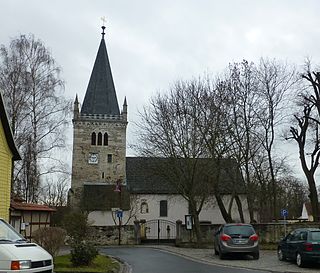
Mühlhausen is a town in the north-west of Thuringia, Germany, 5 km north of Niederdorla, the country's geographical centre, 50 km north-west of Erfurt, 65 km east of Kassel and 50 km south-east of Göttingen.

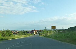
Vrbas is a town and municipality located in the South Bačka District of the autonomous province of Vojvodina, Serbia. As of 2022, the town has a population of 20,892, while the municipality has 36,601 inhabitants.

Kula is a town and municipality located in the West Bačka District of the autonomous province of Vojvodina, Serbia. The town has a population of 22,105, while the municipality has a population of 35,592.

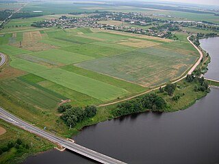
The Region of Southern Denmark is an administrative region of Denmark established on Monday 1 January 2007 as part of the 2007 Danish Municipal Reform, which abolished the traditional counties ("amter") and set up five larger regions. At the same time, smaller municipalities were merged into larger units, cutting the number of municipalities from 270 before 1 January 2007 to 98. The reform diminished the power of the regional level dramatically in favor of the local level and the central government in Copenhagen. The Region of Southern Denmark has 22 municipalities. The reform was implemented in Denmark on 1 January 2007, although the merger of the Funish municipalities of Ærøskøbing and Marstal, being a part of the reform, was given the go-ahead to be implemented on Sunday 1 January 2006, one year before the main reform. It borders Schleswig-Holstein (Germany) to the south and Central Denmark Region to the north and is connected to Region Zealand via the Great Belt Fixed Link.

Municipalities are the lowest level of official territorial division in Germany. This can be the second, third, fourth or fifth level of territorial division, depending on the status of the municipality and the Land it is part of. The city-states Berlin and Hamburg are second-level divisions. A Gemeinde is one level lower in those states which also include Regierungsbezirke as an intermediate territorial division. The Gemeinde is one level higher if it is not part of a Gemeindeverband.
Kėdainiai District Municipality is one of 60 municipalities in Lithuania, located in the central part of the country.

Bartošovice v Orlických horách is a municipality and village in Rychnov nad Kněžnou District in the Hradec Králové Region of the Czech Republic. It has about 200 inhabitants.

Mosty u Jablunkova is a municipality and village in Frýdek-Místek District in the Moravian-Silesian Region of the Czech Republic. It has about 3,700 inhabitants. The municipality has a significant Polish minority.

Vidzeme is one of the Historical Latvian Lands. The capital of Latvia, Riga, is situated in the southwestern part of the region. Literally meaning "the Middle Land", it is situated in north-central Latvia north of the Daugava River. Sometimes in German, it was also known as Livland, the German form from Latin Livonia, though it comprises only a small part of Medieval Livonia and about half of Swedish Livonia. Most of the region's inhabitants are Latvians (85%), thus Vidzeme is the most ethnically Latvian region in the country.
Unstruttal is a municipality in the Unstrut-Hainich-Kreis district of Thuringia, Germany. It was created in September 1995 by the merger of the former municipalities Ammern, Dachrieden, Eigenrode, Horsmar, Kaisershagen and Reiser. In January 2023 Unstruttal absorbed the former municipality Menteroda, the villages Dörna and Lengefeld from the former municipality Anrode, and Zaunröden from the former municipality Dünwald.

Hans Grodotzki was an East German long-distance runner who competed mainly in track events.

Josef Blösche was a convicted war criminal and a member of the Nazi Party who served in the SS and SD during World War II. Blösche shot and killed many Jews, and helped send many more Jews to their deaths in extermination camps. He also participated in several massacres.
Unstrut-Hainich-Kreis I is an electoral constituency represented in the Landtag of Thuringia. It elects one member via first-past-the-post voting. Under the current constituency numbering system, it is designated as constituency 8. It covers the northwestern part of Unstrut-Hainich-Kreis.
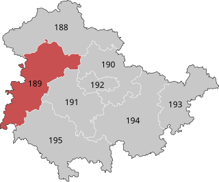
Eisenach – Wartburgkreis – Unstrut-Hainich-Kreis is an electoral constituency represented in the Bundestag. It elects one member via first-past-the-post voting. Under the current constituency numbering system, it is designated as constituency 189. It is located in western Thuringia, comprising the city of Eisenach and the districts of Wartburgkreis and Unstrut-Hainich-Kreis.

Jena – Sömmerda – Weimarer Land I is an electoral constituency represented in the Bundestag. It elects one member via first-past-the-post voting. Under the current constituency numbering system, it is designated as constituency 190. It is located in north-central Thuringia, comprising the city of Jena, the Sömmerda district, and most of the Weimarer Land district.