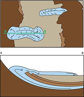
The Messinian Erosional Crisis is a phase in the Messinian evolution of the central Mediterranean basin resulting from major drawdown of the Mediterranean seawater (the "Messinian Salinity Crisis").
The Messinian is in the geologic timescale the last age or uppermost stage of the Miocene. It spans the time between 7.246 ± 0.005 Ma and 5.333 ± 0.005 Ma. It follows the Tortonian and is followed by the Zanclean, the first age of the Pliocene.
The Mediterranean Sea is a sea connected to the Atlantic Ocean, surrounded by the Mediterranean Basin and almost completely enclosed by land: on the north by Southern Europe and Anatolia, on the south by North Africa and on the east by the Levant. Although the sea is sometimes considered a part of the Atlantic Ocean, it is usually identified as a separate body of water. Geological evidence indicates that around 5.9 million years ago, the Mediterranean was cut off from the Atlantic and was partly or completely desiccated over a period of some 600,000 years, the Messinian salinity crisis, before being refilled by the Zanclean flood about 5.3 million years ago.
Seawater, or salt water, is water from a sea or ocean. On average, seawater in the world's oceans has a salinity of about 3.5%. This means that every kilogram of seawater has approximately 35 grams (1.2 oz) of dissolved salts. Average density at the surface is 1.025 kg/L. Seawater is denser than both fresh water and pure water because the dissolved salts increase the mass by a larger proportion than the volume. The freezing point of seawater decreases as salt concentration increases. At typical salinity, it freezes at about −2 °C (28 °F). The coldest seawater ever recorded was in 2010, in a stream under an Antarctic glacier, and measured −2.6 °C (27.3 °F). Seawater pH is typically limited to a range between 7.5 and 8.4. However, there is no universally accepted reference pH-scale for seawater and the difference between measurements based on different reference scales may be up to 0.14 units.
As outlined in numerous studies, erosional events along the margins of the Mediterranean Basin during the Messinian timespan, before and during the evaporite deposition, were common. [1] Those authors showed that also predating the deposition of the first cycle of evaporites, a major erosional phase can be observed along the basin margins, corresponding to a major "relative sea level drop", associated with tectonic activity (marking the end of the so-called "Mes-1" unconformity bound depositional sequence). Following this assumption that this major event corresponds to the major Messinian drawdown, Bache et al. (2009) [2] concluded that the Mediterranean bathymetry significantly decreased before the precipitation of central basin evaporites. Van Dijk et al. (1998) [1] had termed this end member scenario the "Hunchback Scenario". Regarding these works, a deep water formation for central Messinian evaporites seems unlikely. The assumption that central basin evaporites partly deposited under a high bathymetry and before the major phase of erosion should imply the observation of a major detritic event above evaporites in the basin. Such a depositional geometry has not been observed on data, as the detritic wedges are merely confined to the basin marginal areas.
In earth science, erosion is the action of surface processes that removes soil, rock, or dissolved material from one location on the Earth's crust, and then transports it to another location. This natural process is caused by the dynamic activity of erosive agents, that is, water, ice (glaciers), snow, air (wind), plants, animals, and humans. In accordance with these agents, erosion is sometimes divided into water erosion, glacial erosion, snow erosion, wind (aeolic) erosion, zoogenic erosion, and anthropogenic erosion. The particulate breakdown of rock or soil into clastic sediment is referred to as physical or mechanical erosion; this contrasts with chemical erosion, where soil or rock material is removed from an area by its dissolving into a solvent, followed by the flow away of that solution. Eroded sediment or solutes may be transported just a few millimetres, or for thousands of kilometres.
Evaporite is the term for a water-soluble mineral sediment that results from concentration and crystallization by evaporation from an aqueous solution. There are two types of evaporite deposits: marine, which can also be described as ocean deposits, and non-marine, which are found in standing bodies of water such as lakes. Evaporites are considered sedimentary rocks and are formed by chemical sediments.
Relative sea level is defined as the sea level that is observed with respect to a land-based reference frame. It is often contrasted with eustatic sea level, which is a measure of the total mass or volume of the oceans. Relative sea level can change by the processes changing eustatic sea level, but also by changes on land such as subsidence and isostatic rebound.
Another major point of discussion regards the presence of erosional deep canyons along the continental margins of the Basins. These should be expected to be present because of the assumption of a major sea level drop. In fact, they have been described by several authors (summarized in e.g. Clauzon et al., 1996). [3] Most of them are infilled by early Pliocene sediments. As outlined in van Dijk et al. (1998) [1] this phenomenon can be explained in two ways: A major eustatic sea level drop, or a tectonic uplift of the margins (as one associated with a minor sea level drop). It constitutes, therefore, not a real proof for the desiccation of an existing originally deep basin.
A canyon or gorge is a deep cleft between escarpments or cliffs resulting from weathering and the erosive activity of a river over geologic timescales. Rivers have a natural tendency to cut through underlying surfaces, eventually wearing away rock layers as sediments are removed downstream. A river bed will gradually reach a baseline elevation, which is the same elevation as the body of water into which the river drains. The processes of weathering and erosion will form canyons when the river's headwaters and estuary are at significantly different elevations, particularly through regions where softer rock layers are intermingled with harder layers more resistant to weathering.
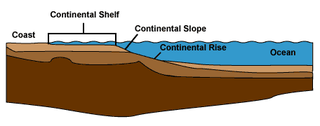
The continental margin is one of the three major zones of the ocean floor, the other two being deep-ocean basins and mid-ocean ridges. The continental margin is the shallow water area found in proximity to continent. The continental margin consists of three different features: the continental rise, the continental slope, and the continental shelf. Continental margins constitute about 28% of the oceanic area.[1]
Mean sea level (MSL) is an average level of the surface of one or more of Earth's bodies of water from which heights such as elevation may be measured. The global MSL is a type of vertical datum – a standardised geodetic datum – that is used, for example, as a chart datum in cartography and marine navigation, or, in aviation, as the standard sea level at which atmospheric pressure is measured to calibrate altitude and, consequently, aircraft flight levels. A common and relatively straightforward mean sea-level standard is instead the midpoint between a mean low and mean high tide at a particular location.
The third much-disputed element is the recognition of the so-called "MES", the Messinian Erosional Surface. This surface can well be traced in seismic sections along the Basin margins, showing angular and non-angular unconformities, somewhere within the evaporite deposits, or between evaporite and non-evaporite deposits. Nice examples are shown by Roveri et al. (2008). [4] As already extensively discussed in van Dijk (1992), [5] the erosional surfaces within the Messinian clastic and evaporitic and mixed series are often confused. Only very high resolution and complete series such as those in the Crotone Basin in Calabria can solve this matter, and the authors have shown that the erosional surfaces and there probable relationships with relative sea level fluctuations and tectonic activity can be mapped well (see review in van Dijk et al., 1998 [1] ).
Seismology is the scientific study of earthquakes and the propagation of elastic waves through the Earth or through other planet-like bodies. The field also includes studies of earthquake environmental effects such as tsunamis as well as diverse seismic sources such as volcanic, tectonic, oceanic, atmospheric, and artificial processes such as explosions. A related field that uses geology to infer information regarding past earthquakes is paleoseismology. A recording of earth motion as a function of time is called a seismogram. A seismologist is a scientist who does research in seismology.
Calabria, known in antiquity as Bruttium, is a region in Southern Italy.
Sedimentary rocks are types of rock that are formed by the accumulation or deposition of small particles and subsequent cementation of mineral or organic particles on the floor of oceans or other bodies of water at the Earth's surface. Sedimentation is the collective name for processes that cause these particles to settle in place. The particles that form a sedimentary rock are called sediment, and may be composed of geological detritus (minerals) or biological detritus. Before being deposited, the geological detritus was formed by weathering and erosion from the source area, and then transported to the place of deposition by water, wind, ice, mass movement or glaciers, which are called agents of denudation. Biological detritus was formed by bodies and parts of dead aquatic organisms, as well as their fecal mass, suspended in water and slowly piling up on the floor of water bodies. Sedimentation may also occur as dissolved minerals precipitate from water solution.
The Permian Basin is a large sedimentary basin in the southwestern part of the United States. The basin contains the Mid-Continent Oil Field province. This sedimentary basin is located in western Texas and southeastern New Mexico. It reaches from just south of Lubbock, past Midland and Odessa, south nearly to the Rio Grande River in southern West Central Texas, and extending westward into the southeastern part of New Mexico. It is so named because it has one of the world's thickest deposits of rocks from the Permian geologic period. The greater Permian Basin comprises several component basins; of these, the Midland Basin is the largest, Delaware Basin is the second largest, and Marfa Basin is the smallest. The Permian Basin covers more than 86,000 square miles (220,000 km2), and extends across an area approximately 250 miles (400 km) wide and 300 miles (480 km) long.
In geology and geomorphology a base level is the lower limit for an erosion process. The modern term was introduced by John Wesley Powell in 1875. The term was subsequently appropriated by William Morris Davis who used it in his cycle of erosion theory. The "ultimate base level" is the plane that results from projection of the sea level under landmasses. It is to this base level that topography tends to approach due to erosion, eventually forming a peneplain close to the end of a cycle of erosion.
A salt dome is a type of structural dome formed when a thick bed of evaporite minerals found at depth intrudes vertically into surrounding rock strata, forming a diapir. It is important in petroleum geology because salt structures are impermeable and can lead to the formation of a stratigraphic trap.
The Los Angeles Basin is a sedimentary basin located in southern California, in a region known as the Peninsular Ranges. The basin is also connected to an anomalous group of east-west trending chains of mountains collectively known as the California Transverse Ranges. The present basin is a coastal lowland area, whose floor is marked by elongate low ridges and groups of hills that is located on the edge of the Pacific plate. The Los Angeles Basin, along with the Santa Barbara Channel, the Ventura Basin, the San Fernando Valley, and the San Gabriel Basin, lies within the greater southern California region. On the north, northeast, and east, the lowland basin is bound by the Santa Monica Mountains and Puente, Elysian, Repetto hills. To the southeast, the basin is bordered by the Santa Ana mountains and the San Joaquin Hills. The western boundary of the basin is marked by the Continental Borderland and is part of the onshore portion. The California borderland is characterized by north-west trending offshore ridges and basins. The Los Angeles Basin is notable for its great structural relief and complexity in relation to its geologic youth and small size for its prolific oil production. Yerkes et al. identify 5 major stages of the basin's evolution that begins in the Upper Cretaceous and ends in the Pleistocene. This basin can be classified as an irregular pull-apart basin accompanied by rotational tectonics during the post-early Miocene.
The Messinian Salinity Crisis (MSC), also referred to as the Messinian Event, and in its latest stage as the Lago Mare event, was a geological event during which the Mediterranean Sea went into a cycle of partly or nearly complete desiccation throughout the latter part of the Messinian age of the Miocene epoch, from 5.96 to 5.33 Ma. It ended with the Zanclean flood, when the Atlantic reclaimed the basin.
In biogeography, the Mediterranean Basin is the region of lands around the Mediterranean Sea that have a Mediterranean climate, with mild, rainy winters and hot, dry summers, which supports characteristic Mediterranean forests, woodlands, and scrub vegetation.
The Sorbas Basin is a sedimentary basin around the town of Sorbas in Almeria Province in south-east Spain. It is believed to have been formed by extension, between two fault-bounded blocks which rotated anti-clockwise to take up the compression resulting from Europe's collision with Africa. The basin is filled with turbidites and evaporites of the Tortonian-Messinian ages of the Miocene Epoch.
Salt surface structures are extensions of salt tectonics that form at the Earth's surface when either diapirs or salt sheets pierce through the overlying strata. They can occur in any location where there are salt deposits, namely in cratonic basins, synrift basins, passive margins and collisional margins. These are environments where mass quantities of water collect and then evaporate; leaving behind salt and other evaporites to form sedimentary beds. When there is a difference in pressure, such as additional sediment in a particular area, the salt beds – due to the unique ability of salt to behave as a fluid under pressure – form into new structures. Sometimes, these new bodies form subhorizontal or moderately dipping structures over a younger stratigraphic unit, which are called allochthonous salt bodies or salt surface structures.
The Persian Gulf Basin, is found between the Eurasian and the Arabian Plates. The Persian Gulf is described as a shallow marginal sea of the Indian Ocean that is located between the south western side of Iran and the Arabian Peninsula and south and southeastern side of Oman and the United Arab Emirates. Other countries that border the Persian Gulf basin include; Saudi Arabia, Qatar, Kuwait, Bahrain and Iraq. The Gulf extends a distance of 1000 km with an area of 240,000 square km. The Persian Gulf basin is a wedge-shaped foreland basin which lies beneath the western Zagros thrust and was created as a result of the collision between the Arabian and Eurasian plates.
The North Sea basin is located in northern Europe and lies between the United Kingdom, and Norway just north of The Netherlands and can be divided into many sub-basins. The Southern North Sea basin is the largest gas producing basin in the UK continental shelf, with production coming from the lower Permian sandstones which are sealed by the upper Zechstein salt. The evolution of the North Sea basin occurred through multiple stages throughout the geologic timeline. First the creation of the Sub-Cambrian peneplain, followed by the Caledonian Orogeny in the late Silurian and early Devonian. Rift phases occurred in the late Paleozoic and early Mesozoic which allowed the opening of the northeastern Atlantic. Differential uplift occurred in the late Paleogene and Neogene. The geology of the Southern North Sea basin has a complex history of basinal subsidence that had occurred in the Paleozoic, Mesozoic, and Cenozoic. Uplift events occurred which were then followed by crustal extension which allowed rocks to become folded and faulted late in the Paleozoic. Tectonic movements allowed for halokinesis to occur with more uplift in the Mesozoic followed by a major phase of inversion occurred in the Cenozoic affecting many basins in northwestern Europe. The overall saucer-shaped geometry of the southern North Sea Basin indicates that the major faults have not been actively controlling sediment distribution.
The North German Basin is a passive-active rift basin located in central and west Europe, lying within the southeastern most portions of the North Sea and the southwestern Baltic Sea and across terrestrial portions of northern Germany, Netherlands, and Poland. The North German Basin is a sub-basin of the Southern Permian Basin, that accounts for a composite of intra-continental basins composed of Permian to Cenozoic sediments, which have accumulated to thicknesses around 10–12 kilometres (6–7.5 mi). The complex evolution of the basin takes place from the Permian to the Cenozoic, and is largely influenced by multiple stages of rifting, subsidence, and salt tectonic events. The North German Basin also accounts for a significant amount of Western Europe's natural gas resources, including one of the worlds largest natural gas reservoir, the Groningen gas field.
The Prairie Evaporite Formation, also known as the Prairie Formation, is a geologic formation of Middle Devonian (Givetian) age that consists primarily of halite and other evaporite minerals. It is present beneath the plains of northern and eastern Alberta, southern Saskatchewan and southwestern Manitoba in Canada, and it extends into northwestern North Dakota and northeastern Montana in the United States.
The geology of Sicily records the collision of the Eurasian and the African plates during westward-dipping subduction of the African slab since late Oligocene. Major tectonic units are the Hyblean foreland, the Gela foredeep, the Apenninic-Maghrebian orogen, and the Calabrian Arc. The orogen represents a fold-thrust belt that folds Mesozoic carbonates, while a major volcanic unit is found in an eastern portion of the island. The collision of Africa and Eurasia is a retreating subduction system, such that the descending Africa is falling away from Eurasia, and Eurasia extends and fills the space as the African plate falls into the mantle, resulting in volcanic activity in Sicily and the formation of Tyrrhenian slab to the north.
The Zanclean flood or Zanclean deluge is a flood theorized to have refilled the Mediterranean Sea 5.33 million years ago. This flooding ended the Messinian salinity crisis and reconnected the Mediterranean Sea to the Atlantic Ocean, although it is possible that even before the flood there were partial connections to the Atlantic Ocean. The reconnection marks the beginning of the Zanclean age.
Á
The Ipubi Formation is the middle geological formation of the Santana Group, the middle part of the Araripe Group, in the Araripe Basin of northeastern Brazil. The formation is dated to the Aptian to Albian stages of the Early Cretaceous, unconformably overlying the Crato Formation and unconformably overlain by the Romualdo Formation, formerly known as the Romualdo Member of the Santana Formation. The averaging 15 metres (49 ft) thick Ipubi Formation comprises shales and sandstones in the lower section and evaporites in the upper part of the formation, deposited in a transgressive to highstand lacustrine environment in the Araripe rift basin.
The geology of the United Arab Emirates includes very thick Paleozoic, Mesozoic and Cenozoic marine and continental sedimentary rocks overlying deeply buried Precambrian. The region has extensive oil and gas resources and was deformed during the last several million years by more distant tectonic events.
The geology of Jordan includes thick sedimentary sequences of sandstone, marl and evaporites atop ancient Precambrian crystalline igneous and metamorphic basement rock.