Related Research Articles

Amyclae or Amyklai was a city of ancient Laconia, situated on the right or western bank of the Eurotas, 20 stadia south of Sparta, in a district remarkable for the abundance of its trees and its fertility. Amyclae was one of the most celebrated cities of Peloponnesus in the Greek Heroic Age. It is said to have been founded by the Lacedaemonian king Amyclas, the father of Hyacinthus, and to have been the abode of Tyndarus, and of Castor and Pollux, who are hence called Amyclaei Fratres. Amyclae is mentioned by Homer, and it continued to maintain its independence as an Achaean town long after the conquest of Peloponnesus by the Dorians.
Pisa is a village situated 2.15 kilometres (1.34 mi) to the east of Olympia, Greece, located on the northwest side of the Peloponnesus peninsula. Currently it is not politically independent but it is a community of the municipality of Ancient Olympia, in the regional unit of Elis.

Andania is a former municipality in Messenia, Peloponnese, Greece. Since the 2011 local government reform, it has been a municipal unit of the municipality of Oichalia. The municipal unit has an area of 88.694 km2. Population 1,820 (2021). The seat of the municipality was in Diavolitsi.
Pylus or Pylos was a town in hollow Elis, described by Pausanias as situated upon the mountain road leading from Elis to Olympia, and at the place where the Ladon flows into the Pineus. Strabo, in a corrupt passage, assigns to it the same situation, and places it in the neighbourhood of Scollium or Mount Scollis. Pausanias says that it was 80 stadia from the city of Elis. Diodorus gives 70 stadia as the distance, and Pliny the Elder 12 Roman miles.
Thelpusa or Thelpousa, or Telphusa or Telphousa (Τέλφουσα), was a town in the west of ancient Arcadia, situated upon the left or eastern bank of the river Ladon. Its territory was bounded on the north by that of Psophis, on the south by that of Heraea, on the west by the Eleia and Tisatis, and on the east by that of Cleitor, Tripolis, and Theisoa. The town is said to have derived its name from a nymph, the daughter of the Ladon, which nymph was probably the stream flowing through the lower part of the town into the Ladon.
Caryae or Karyai was a town of ancient Laconia upon the frontiers of Arcadia. It was originally an Arcadian town belonging to Tegea, but was conquered by the Spartans and annexed to their territory. Caryae revolted from Sparta after the Battle of Leuctra (371 BCE), and offered to guide a Theban army into Laconia; but shortly afterwards it was severely punished for its treachery, for Archidamus III took the town and put to death all the inhabitants who were made prisoners.
Thuria or Thouria was a town of ancient Messenia, situated in the eastern part of the southern Messenian plain, upon the river Aris, and at the distance of 80 stadia from Pharae, which was about a mile from the coast. It was generally identified with the Homeric Antheia, though others supposed it to be Aepeia. It must have been a place of considerable importance, since the distant Messenian Gulf was even named after it. It was also one of the chief towns of the Lacedaemonian Perioeci after the subjugation of Messenia; and it was here that the Third Messenian War took its rise in 464 BCE. On the restoration of the Messenians by Epaminondas, Thuria, like the other towns in the country, was dependent upon the newly-founded capital Messene; but after the capture of that city by the Achaeans in 182 BCE, Thuria, Pharae, and Abia joined the Achaean League as independent members. Thuria was annexed to Laconia by Augustus; but it was restored to Messenia by Tiberius.

Pheneus or Pheneos was a town in the northeast of ancient Arcadia. Its territory, called Pheniatis, was bounded on the north by that of the Achaean towns of Aegeira and Pellene, east by the Stymphalia, west by the Cleitoria, and south by the Caphyatis and Orchomenia. This territory is shut in on every side by lofty mountains, offshoots of Mount Cyllene and the Aroanian chain; and it is about 7 miles (12 km) in length and the same in breadth. Two streams descend from the northern mountains, and unite their waters about the middle of the valley; the united river bore in ancient times the name of Olbius and Aroanius. There is no opening through the mountains on the south; but the waters of the united river are carried off by subterranean channels (katavóthra) in the limestone rocks, and, after flowing underground, reappear as the sources of the river Ladon. In order to convey the waters of this river in a single channel to the katavóthra, the inhabitants at an early period constructed a canal, 50 stadia in length, and 30 feet in breadth.
Pharae was an ancient town of Messenia, situated upon a hill rising from the left bank of the river Nedon, and at a distance of a mile (1.5 km) from the Messenian Gulf. Strabo describes it as situated 5 stadia from the sea, and Pausanias 6. William Smith states that it is probable that the earth deposited at the mouth of the river Nedon has, in the course of centuries, encroached upon the sea. Pausanias distinguishes this city from the Achaean city of Pharae (Φαραὶ), 150 stadia from Patrae and 70 stadia from the coast. Pherae occupied the site of Kalamata, the modern capital of Messenia; and in antiquity also it seems to have been the chief town in the southern Messenian plain.
Phare or Pharis (Φᾶρις), afterwards called Pharae (Φαραί), was a town of Laconia in the Spartan plain, situated upon the road from Amyclae to the sea. It was mentioned in the Catalog of ships in the Iliad, and was one of the ancient Achaean towns. It maintained its independence till the reign of Teleclus, king of Sparta; and, after its conquest, continued to be a Lacedaemonian town under the name of Pharae. It was said to have been plundered by Aristomenes in the Second Messenian War. It is also mentioned in a corrupt passage of Strabo, and by other ancient writers.
Oechalia or Oichalia was a town in ancient Messenia, in the plain of Stenyclerus. It was in ruins in the time of Epaminondas, and its position was a matter of dispute in later times. Strabo identified it with Andania, the ancient residence of the Messenian kings, and Pausanias with Carnasium, which was only 8 stadia distant from Andania, and upon the river Charadrus. Carnasium, in the time of Pausanias, was the name given to a grove of cypresses, in which were statues of Apollo Carneius, of Hermes Criophorus, and of Persephone. It was here that the mystic rites of the great goddesses were celebrated, and that the urn was preserved containing the bones of Eurytus, the son of Melaneus.
Cyllene or Kyllene was a seaport town of ancient Elis, distant 120 stadia from the city of Elis. Cyllene was an ancient place. It is mentioned by Homer as one of the towns of the Epeians; and if we are to believe Dionysius Periegetes, it was the port from which the Pelasgians sailed to Italy. Pausanias, moreover, mentions it as visited at an early period by the merchants of Aegina, and as the port from which the exiled Messenians after the conclusion of the Second Messenian War, sailed away to found a colony in Italy or Sicily.
Thalamae or Thalamai was a town of ancient Laconia, which at various times belonged to Messenia.
Leuctra or Leuktra, also Leuctrum or Leuktron, was a town of ancient Laconia, situated on the eastern side of the Messenian Gulf, 20 stadia north of Pephnus, and 60 stadia south of Cardamyle. Strabo speaks of Leuctrum as a colony of the Leuctra in Boeotia, near the minor Pamisus, but this river flows into the sea at Pephnus, about three miles (5 km) south of Leuctrum.
Asine was a town of ancient Messenia, which was built by the Dryopes, when they were expelled from Asine in the Argeia. In one of the early wars (740 BCE) between the Lacedaemonians and the Argives, the Asinaeans joined the former when they invaded the Argive territory under their king Nicander; but as soon as the Lacedaemonians returned home, the Argives laid siege to Asine and razed it to the ground, sparing only the temple of the Pythaëus Apollo. The Asinaeans escaped by sea; and the Lacedaemonians gave to them, after the end of the First Messenian War, a portion of the Messenian territory, where they built the Messenian Asine.
Stenyclarus or Stenyklaros, or Stenyclerus or Stenykleros (Στενύκληρος), was a town in the north of ancient Messenia, and the capital of the Dorian conquerors, built by Cresphontes. Andania had been the ancient capital of the country. The town afterwards ceased to exist, but its name was given to the northern of the two Messenian plains and site of a battle where Messenians defeated a small Spartan army.
Eira, also known as Hira or Ira (Ἰρά), and Hire or Ire (Ἱρὴ), was a fortified settlement on a mountain of the same name, in the north of ancient Messenia, near the Neda River. During the Second Messenian War the Messenians fortified the place, and Aristomenes defended it for ten years against the Spartans. Pausanias dates the capture of the city by the Lacedaemonians to the first year of the 28th Olympiad (668 BCE). The Arcadians welcomed many Messenians who withdrew thither after the capture of Eira, while the captured Messenian prisoners were converted to helots by the Lacedaemonians, and the rest of Messenians who lived on the coast were exiled to Cyllene, in Elis. Pausanias adds that 297 years after the capture of Eira, in the third year of the 102nd Olympiad (370 BCE), the Messenians regained their territory.
Corone or Korone was a town of ancient Messenia, situated upon the western side of the Messenian Gulf, which was sometimes called after it, the Coronaean. According to Pausanias, it was built on the site of the Homeric Aepeia, at the time of the restoration of the Messenians to their native country, by Epaminondas; and received the name of Coroneia because Epimelides, who founded the new town, was a native of Coroneia, in Boeotia. This name was changed by the Messenians into that of Corone. According to others, Corone corresponded to the Homeric Pedasus.
Pedasus or Pedasos was a town of ancient Messenia, mentioned by Homer in the Iliad as one of the seven towns of Messenia offered by Agamemnon to Achilles, and described by him as ἀμπελόεσσα ('vine-covered'). Ancient authors identify its location with the later Methone.
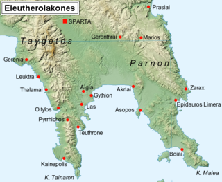
Epidaurus Limera or Epidauros Limera was a town on the eastern coast of ancient Laconia, situated at the head of a spacious bay. It was a colony from Epidaurus in Argolis, and is said to have been built in consequence of an intimation from Asclepius, when an Epidaurian ship touched here on its way to Cos. Its foundation probably belongs to the time when the whole of the eastern coast of Laconia, as far as the promontory Malea, acknowledged the supremacy of Argos. The epithet Limera was considered by the best ancient critics to be given to the town on account of the excellence of its harbours, though other explanations were proposed of the word. Pausanias describes the town as situated on a height not far from the sea. He mentions among its public buildings temples of Aphrodite and Asclepius, a temple of Athena on the acropolis, and a temple of Zeus Soter in front of the harbour.
References
- ↑ Periplus of Pseudo-Scylax , p. 17
- 1 2 3 Pausanias (1918). "35.1". Description of Greece. Vol. 4. Translated by W. H. S. Jones; H. A. Ormerod. Cambridge, Massachusetts; London: Harvard University Press; William Heinemann – via Perseus Digital Library.
- ↑ William Martin Leake, Morea, vol i. p. 429 et seq.
- ↑ Strabo. Geographica . Vol. viii. p.359. Page numbers refer to those of Isaac Casaubon 's edition.
- ↑ Homer. Iliad . Vol. 9.294.
- ↑ Pausanias (1918). "18.1". Description of Greece. Vol. 4. Translated by W. H. S. Jones; H. A. Ormerod. Cambridge, Massachusetts; London: Harvard University Press; William Heinemann – via Perseus Digital Library., 4.23.1.
- ↑ Pausanias (1918). "24.4". Description of Greece. Vol. 4. Translated by W. H. S. Jones; H. A. Ormerod. Cambridge, Massachusetts; London: Harvard University Press; William Heinemann – via Perseus Digital Library., 4.35.2.
- ↑ Pausanias (1918). "27.8". Description of Greece. Vol. 4. Translated by W. H. S. Jones; H. A. Ormerod. Cambridge, Massachusetts; London: Harvard University Press; William Heinemann – via Perseus Digital Library.
- ↑ Thucydides. History of the Peloponnesian War . Vol. 2.25.
- ↑ Pausanias (1918). "35.6". Description of Greece. Vol. 4. Translated by W. H. S. Jones; H. A. Ormerod. Cambridge, Massachusetts; London: Harvard University Press; William Heinemann – via Perseus Digital Library., 7.
- ↑ Dio Cassius 1. 11; Oros. 6.19; Strabo. Geographica . Vol. viii. p.359. Page numbers refer to those of Isaac Casaubon 's edition.
- ↑ Pausanias (1918). "35.3". Description of Greece. Vol. 4. Translated by W. H. S. Jones; H. A. Ormerod. Cambridge, Massachusetts; London: Harvard University Press; William Heinemann – via Perseus Digital Library.
- ↑ Pomponius Mela. De situ orbis. Vol. 2.3.
- ↑ Pliny. Naturalis Historia . Vol. 4.5.7.
- ↑ Ptolemy. The Geography . Vol. 3.15.7.
- ↑ Hierocles. Synecdemus . Vol. p. 647.
- ↑ Richard Talbert, ed. (2000). Barrington Atlas of the Greek and Roman World . Princeton University Press. p. 58, and directory notes accompanying. ISBN 978-0-691-03169-9.
- ↑ Lund University. Digital Atlas of the Roman Empire.
- ↑ Chatzidaki, E. (1994). "Η Εφορεία Εναλίων Αρχαιοτήτων και τα Προγράμματα Υποβρυχίων Ανασκαφών" (PDF). Αρχαιολογία (in Greek). 51: 86–88. Archived from the original (PDF) on October 11, 2010.
![]() This article incorporates text from a publication now in the public domain : Smith, William, ed. (1854–1857). "Methone". Dictionary of Greek and Roman Geography . London: John Murray.
This article incorporates text from a publication now in the public domain : Smith, William, ed. (1854–1857). "Methone". Dictionary of Greek and Roman Geography . London: John Murray.