Gurguri is a village and Union Council of Karak District in Khyber Pakhtunkhwa province of Pakistan. It is located at 33°17'54N 70°47'11E with an altitude of 902 metres.
Tytlewo is a village in the administrative district of Gmina Lisewo, within Chełmno County, Kuyavian-Pomeranian Voivodeship, in north-central Poland.

Konary is a village in the administrative district of Gmina Wodzisław, within Jędrzejów County, Świętokrzyskie Voivodeship, in south-central Poland. It lies approximately 8 kilometres (5 mi) east of Wodzisław, 12 km (7 mi) south of Jędrzejów, and 46 km (29 mi) south-west of the regional capital Kielce.
Michałów is a village in the administrative district of Gmina Sadowie, within Opatów County, Świętokrzyskie Voivodeship, in south-central Poland. It lies approximately 6 kilometres (4 mi) south-west of Sadowie, 10 km (6 mi) west of Opatów, and 49 km (30 mi) east of the regional capital Kielce.
Prędocin-Kolonia is a village in the administrative district of Gmina Iłża, within Radom County, Masovian Voivodeship, in east-central Poland. It lies approximately 4 kilometres (2 mi) south-east of Iłża, 30 km (19 mi) south of Radom, and 121 km (75 mi) south of Warsaw.
Podrogów is a village in the administrative district of Gmina Sokołów Podlaski, within Sokołów County, Masovian Voivodeship, in east-central Poland. It lies approximately 4 kilometres (2 mi) east of Sokołów Podlaski and 92 km (57 mi) east of Warsaw.

Xanlıqlar is a village in the Qazakh Rayon of Azerbaijan. It has a population of 3,111. Xanliqlar is a place in Azerbaijan about 245 mi west of Baku, the country's capital city.

Przewóz is a village in the administrative district of Gmina Cisek, within Kędzierzyn-Koźle County, Opole Voivodeship, in south-western Poland. It lies approximately 8 kilometres (5 mi) south-east of Cisek, 15 km (9 mi) south of Kędzierzyn-Koźle, and 54 km (34 mi) south-east of the regional capital Opole.
Starkowa Huta is a village in the administrative district of Gmina Somonino, within Kartuzy County, Pomeranian Voivodeship, in northern Poland. It lies approximately 6 kilometres (4 mi) south of Somonino, 12 km (7 mi) south of Kartuzy, and 34 km (21 mi) south-west of the regional capital Gdańsk.
Dubowo is a village in the administrative district of Gmina Stężyca, within Kartuzy County, Pomeranian Voivodeship, in northern Poland. It lies approximately 3 kilometres (2 mi) north-west of Stężyca, 22 km (14 mi) south-west of Kartuzy, and 49 km (30 mi) west of the regional capital Gdańsk.
Mała Krzeszna is a village in the administrative district of Gmina Stężyca, within Kartuzy County, Pomeranian Voivodeship, in northern Poland. It lies approximately 9 kilometres (6 mi) east of Stężyca, 15 km (9 mi) south-west of Kartuzy, and 40 km (25 mi) south-west of the regional capital Gdańsk.
Piaskowiec is a village in the administrative district of Gmina Ostaszewo, within Nowy Dwór Gdański County, Pomeranian Voivodeship, in northern Poland. It lies approximately 2 kilometres (1 mi) north-east of Ostaszewo, 11 km (7 mi) west of Nowy Dwór Gdański, and 27 km (17 mi) south-east of the regional capital Gdańsk.
Leśno is a village in the administrative district of Gmina Szemud, within Wejherowo County, Pomeranian Voivodeship, in northern Poland. It lies approximately 7 kilometres (4 mi) south-east of Szemud, 18 km (11 mi) south of Wejherowo, and 24 km (15 mi) west of the regional capital Gdańsk.
Babki is a village in the administrative district of Gmina Gołdap, within Gołdap County, Warmian-Masurian Voivodeship, in northern Poland, close to the border with the Kaliningrad Oblast of Russia. It lies approximately 14 kilometres (9 mi) south-east of Gołdap and 137 km (85 mi) east of the regional capital Olsztyn.
Wólka Prusinowska is a village in the administrative district of Gmina Piecki, within Mrągowo County, Warmian-Masurian Voivodeship, in northern Poland. It lies approximately 8 kilometres (5 mi) south of Piecki, 21 km (13 mi) south of Mrągowo, and 54 km (34 mi) east of the regional capital Olsztyn.
Kuce is a village in the administrative district of Gmina Janowiec Kościelny, within Nidzica County, Warmian-Masurian Voivodeship, in northern Poland.
Łukowice is a village in the administrative district of Gmina Cedynia, within Gryfino County, West Pomeranian Voivodeship, in north-western Poland, close to the German border. It lies approximately 8 kilometres (5 mi) north-east of Cedynia, 40 km (25 mi) south of Gryfino, and 60 km (37 mi) south of the regional capital Szczecin.
Kostrzewa is a settlement in the administrative district of Gmina Manowo, within Koszalin County, West Pomeranian Voivodeship, in north-western Poland.
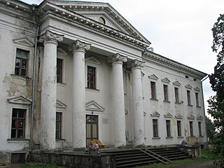
Udriku is a village in Kadrina Parish, Lääne-Viru County, northeastern Estonia, where the Udriku manor, a national architectural monument built in the early nineteenth century, is situated.
Jõevaara is a village in Veriora Parish, Põlva County in southeastern Estonia.


