Pemba South Region or South Pemba Region is one of the 31 regions of Tanzania. The region covers an area of 332 km2 (128 sq mi). The region is comparable in size to the combined land area of the nation state of Grenada. and the administrative region is located entirely on the island of Pemba. Pemba South Region is bordered to the south by Indian Ocean, north by Pemba North Region and the west by Pemba channel. The regional capital is Mkoani.. The region has the fifth highest HDI in the country, making one of the most developed regions in the country. The region has the highest standard of living on Pemba Island. According to the 2012 census, the region has a total population of 195,116.

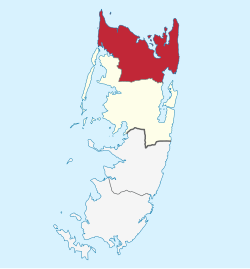
Pemba North Region or North Pemba Region is one of the 31 regions of Tanzania. The region covers an area of 574 km2 (222 sq mi). The region is comparable in size to the combined land area of the nation state of Saint Lucia. and the administrative region is located entirely on the island of Pemba. Pemba North Region is bordered to the north by Indian Ocean, south by Pemba South Region and the west by Pemba channel. The regional capital is Wete. According to the 2012 census, the region has a total population of 211,732.
Mara Region is one of Tanzania's 31 administrative regions. The region covers an area of 21,760 km2 (8,400 sq mi). The region is comparable in size to the combined land area of the nation state of El Salvador. The neighboring regions are Mwanza Region and Simiyu Region, Arusha Region, and Kagera Region. The Mara Region borders Kenya .The regional capital is the municipality of Musoma. Mara Region is known for being the home of Serengeti National Park, a UNESCO World Heritage site and also the birth place of Tanzania's founding father Julius Nyerere. Under British colonial occupation, the Mara Region was a district called the Lake Province, which became the Lake Region after independence in 1961.

Unguja North Region, Zanzibar North Region or North Zanzibar Region is one of the 31 regions of Tanzania. The region covers an area of 407 km2 (157 sq mi). The region is comparable in size to the combined land area of the nation state of Andorra. and the administrative region is located entirely on the island of Zanzibar. Unguja North Region is bordered on three sides to the north by Indian Ocean, southeast by Unguja South Region and southwest by Mjini Magharibi Region. The regional capital is the town of Mkokotoni. The region has the fifth highest HDI in the country, making one of the most developed regions in the country.According to the 2012 census, the region has a total population of 187, 455. Zanzibar North is divided into two districts, Kaskazini A and Kaskazini B.

Mjini Magharibi Region, Zanzibar Urban West Region or West Zanzibar Region is one of the 31 regions of Tanzania. The region covers an area of 230 km2 (89 sq mi). The region is located entirely on the island of Zanzibar and bordered to the west by the Indian Ocean, north by Unguja North Region and the east by Unguja South Region. The region is home to one of the seven World Heritage Sites located in Tanzania, namely; Stonetown of Zanzibar. The regional capital is Zanzibar City. The region is the most developed region with the highest human development index in Tanzania at 0.718. According to the 2012 census, the region has a total population of 593,678.
Iringa Region is one of Tanzania's 31 administrative regions. The region covers an area of 35,503 km2 (13,708 sq mi). The region is comparable in size to the combined land area of the nation state of Guinea Bissau. Iringa Region is bordered to the east by Morogoro Region and south by Njombe Region. On the west the region is bordered by Mbeya Region. Dodoma Region and Singida Region border Iringa on the north. The regional capital is the city Iringa for which the city is named after. According to the 2022 census, the region has a total population of 1,192,728. Iringa Region is home to Ruaha National Park, Tanzania's second national largest park.

Kigoma Region is one of Tanzania's 31 administrative regions. The regional capital is the city of Kigoma. Kigoma Region borders Kagera Region, Geita Region, Katavi Region, Tabora Region, DRC and Burundi According to the 2012 national census, the region had a population of 2,127,930, which was higher than the pre-census projection of 1,971,332. For 2002-2012, the region's 2.4 percent average annual population growth rate was tied for the fourteenth highest in the country. It was also the sixteenth most densely populated region with 57 people per square kilometer. With a size of 45,066 square kilometres (17,400 sq mi), the region is slightly smaller than Estonia.

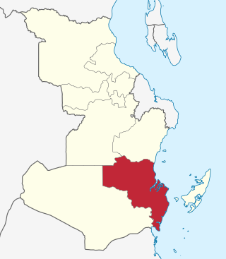
Lindi Region is one of Tanzania's 31 administrative regions. The region covers an area of 66,040 km2 (25,500 sq mi). The region is comparable in size to the combined land area of the nation state of Sri Lanka. The regional capital is the municipality of Lindi.

Tanga Region is one of Tanzania's 31 administrative regions. The region covers an area of 26,667 km2 (10,296 sq mi). The region is comparable in size to the combined land area of the nation state of Burundi. The regional capital is the municipality of Tanga city. Located in northeast Tanzania, the region is bordered by Kenya and Kilimanjaro Region to the north; Manyara Region to the west; and Morogoro and Pwani Regions to the south. It has a coastline to the east with the Indian Ocean. According to the 2022 national census, the region had a population of 2,615,597.

Masasi is one of the six districts of the Mtwara Region of Tanzania. It is bordered to the north by the Lindi Region, to the east by the Newala District, to the south by the Ruvuma River and Mozambique and to the west by Nanyumbu District.

Morogoro Rural District is one of the six districts of the Morogoro Region of Tanzania. Morogoro Rural District covers 19,056 square kilometres (7,358 sq mi). It is bordered to the north and east by the Pwani Region, to the south by Kilombero District, to the southwest by the Kilosa District and to the west by the Mvomero District and the Morogoro Urban District.

Zanzibar City or Mjini District, often simply referred to as Zanzibar is one of two administrative districts of Mjini Magharibi Region in Tanzania. The district covers an area of 15.4 km2 (5.9 sq mi). The district is comparable in size to the land area of Nauru. The district has a water border to the west by the Indian Ocean. The district is bordered to the east by Magharibi District. The district seat is in Stonetown. The city is the largest on the island of Zanzibar. It is located on the west coast of Unguja, the main island of the Zanzibar Archipelago, north of the much larger city of Dar es Salaam across the Zanzibar Channel. The city also serves as the capital of the Zanzibar Urban/West Region. In 2012 its population was 223,033.

Geita Region is one of Tanzania's 31 administrative regions. The region covers an area of 20,054 km2 (7,743 sq mi)."Geita Region Size". The region is comparable in size to the combined land area of the nation state of Slovenia. Geita Region is bordered to the east by Lake Victoria, Mwanza Region and Shinyanga Region. The region is bordered by Tabora Region and Kigoma Region to the south and south west respectively. Lastly, Gieta is borders Kagera Region to the west.

Wete District is one of two administrative districts of Pemba North Region in Tanzania. The district covers an area of 295 km2 (114 sq mi). The district is comparable in size to the land area of Maldives. The district has a water border to the east and west by the Indian Ocean. The district is bordered to the north by Micheweni District. The district seat (capital) is the town of Wete. According to the 2022 census, the district has a total population of 148,712.

Chake Chake District is one of two administrative districts of Pemba South Region in Tanzania. The district covers an area of 219 km2 (85 sq mi). The district is comparable in size to the land area of American Samoa. The district has a water border to the east and west by the Indian Ocean. The district is bordered to the south by Mkoani District and the north by Wete District of Pemba North Region. The district seat (capital) is the town of Chake-Chake. According to the 2012 census, the district has a total population of 97,249.

Mkoani District is one of two administrative districts of Pemba South Region in Tanzania. The district covers an area of 256.2 km2 (98.9 sq mi). The district is comparable in size to the land area of Niue. The district has a water border to the east, south and west by the Indian Ocean. The district is bordered to the north by Chake Chake District. The district seat (capital) is the town of Mkoani. According to the 2012 census, the district has a total population of 97,867.

Kaskazini A District is one of two administrative districts of Unguja North Region in Tanzania. The district covers an area of 229.6 km2 (88.6 sq mi). The district is comparable in size to the land area of Cook Islands. The district is bordered to the north on three sides by the Indian Ocean and to the south by Kaskazini B District. The district seat (capital) is the small town of Kivunge. According to the 2022 census, the district has a total population of 157,369.
Kati District is one of two administrative districts of Unguja South Region in Tanzania. The district covers an area of 505.8 km2 (195.3 sq mi). The district is comparable in size to the land area of Guam. The district has a water border to the east and west by the Indian Ocean. The district is bordered to the north by Kaskazini B District of Unguja North Region. To the south Kati District is bordered by Kusini District. The district seat (capital) is the town of Tunguu. The district is the birthplace of Bi Kidude, most famous Zanzibari musician born in Kitumba Village. According to the 2012 census, the district has a total population of 76,346. The Zanzibar University is located in Tunguu and was founded in 2002.
Chongoleani(Kata ya Chongoleani , in Swahili) is an administrative ward in Tanga City Council of Tanga Region in Tanzania. The Mtimbwani and Kwale wards of Mkinga border the ward to the north. Tanga Bay of Pemba Channel is to the east. The Tanga Bay is to the south. Mabokweni ward is to the west. The ward covers an area of 37 km2 (14 sq mi). and has an average elevation of 10 m (33 ft). According to the 2012 census, the ward has a total population of 4,737.
Kibiti District Council is one of nine administrative districts of Pwani Region in Tanzania. The districts of Mkuranga District and Kisarawe District border the District to the northeast and northwest, respectively. The Mafia Channel forms the district's eastern boundary. The Rufiji District also forms a border to the south of Kibiti. The district covers an area of 2,805 km2 (1,083 sq mi). The district is comparable in size to the land area of Samoa. The district seat (capital) is the town of Kibiti. According to the 2012 census, the district has a total population of 117,752.