Midas, Kentucky

Last updated
Midas, Kentucky
Tunnel at Midas.jpeg
Tunnel at Midas, KY
USA Kentucky location map.svg
Red pog.svg
Midas
Location within the state of Kentucky
Usa edcp location map.svg
Red pog.svg
Midas
Midas (the United States)
Coordinates: 37°30′44″N82°50′06″W / 37.51222°N 82.83500°W / 37.51222; -82.83500
Country United States
State Kentucky
County Floyd
Elevation
709 ft (216 m)
Time zone UTC-05:00 (Eastern (EST))
  Summer (DST) UTC-04:00 (EDT)
ZIP code
41640
GNIS feature ID508596 [1]

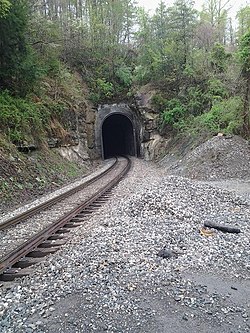
Midas is an unincorporated community located in Floyd County, Kentucky. It is located around the intersection of Midas Road and Kentucky Route 550, North of Hueysville (separated by Midas Tunnel) and West of Eastern. Not much remains except some scattered residences and Midas Road and the Midas Tunnel. CSX E&BV Subdivision passes through Midas and crosses Midas Road after exiting the tunnel.

Contents

Civil War History

On January 10, 1862, the Battle of Middle Creek was fought near Prestonburg. Brig. Gen. Humphrey Marshall and his Confederate troops retreated using the Left Fork of Middle Creek and went south and camped near Midas at the Joseph Gearheart Farm, located midway between Midas and Hueysville. [2] After staying for a week, Humphrey and his troops traveled farther up Beaver Creek before retreating out of Kentucky and into Virginia. [3]

Later history

A 1918 survey noted that the Midas Oil & Gas Company was one of "eighteen or twenty oil and gas operating concerns in Floyd County, Kentucky". [4] By 1927, it was reported that a 9 million cubic foot gas facility was being offered for sale in "Midas, Floyd County, Kentucky, on branch of Chesapeake & Ohio Railway Co.", [5] and in 1937, it was reported that the Inland Gas Corporation had "a sixteen-inch line with a capacity of about thirty-five million cubic feet per day extending from Midas on Right Beaver Creek northwardly" through Floyd County and several neighboring counties. [6] In 1970, the Inland Gas Company sought permission and approval from the Federal Power Commission to abandon its Midas Compressor Station in Floyd County. [7]

Related Research Articles

<span class="mw-page-title-main">Floyd County, Kentucky</span> County in Kentucky, United States

Floyd County is a county located in the U.S. state of Kentucky. As of the 2020 census, the population was 35,942. Its county seat is Prestonsburg. The county, founded in 1800, is named for Colonel John Floyd (1750–1783).

<span class="mw-page-title-main">Allen, Kentucky</span> City in Kentucky, United States

Allen, also known as Allen City, is a home rule-class city in Floyd County, Kentucky, in the United States. The population was 193 at the 2010 census, up from 150 at the 2000 census.

<span class="mw-page-title-main">Martin, Kentucky</span> City in Kentucky, United States

Martin is a home rule-class city in Floyd County, Kentucky, in the United States. The population was 634 as of the 2010 census.

<span class="mw-page-title-main">Wayland, Kentucky</span> City in Floyd County, Kentucky, United States

Wayland is a home rule-class city in Floyd County, Kentucky, United States. The population was 426 at the 2010 census, up from 298 at the 2000 census.

<span class="mw-page-title-main">Louisa, Kentucky</span> City in Kentucky, United States

Louisa is a home-rule class city located in eastern Kentucky at the merger of the Levisa and Tug Forks into the Big Sandy River, which forms part of the state's border with West Virginia. It is the seat of Lawrence County. The population was 2,467 at the 2010 census and an estimated 2,375 in 2018.

<span class="mw-page-title-main">Simeon Willis</span> American lawyer and politician

Simeon Slavens Willis was an American attorney who served as the 46th Governor of Kentucky, United States, serving from 1943 to 1947. He was the only Republican elected governor of Kentucky between 1927 and 1967.

<span class="mw-page-title-main">Humphrey Marshall (general)</span> American politician

Humphrey Marshall was an American lawyer, politician, and military official from Kentucky. During the Antebellum era, he served four terms in the United States House of Representatives, interrupted by a brief stint as ambassador to China. When the American Civil War broke out, he sided with the Confederacy, becoming a brigadier general in the CS Army and then a Confederate Congressman.

Bridgeport is an unincorporated community in western Franklin County, Kentucky, United States, along on U.S. Route 60 outside of Frankfort. It is part of the Frankfort Micropolitan Statistical Area. An elementary school, Bridgeport Elementary, was the focal point of the community for many years. The school has since been replaced by the new Bridgeport Elementary, located in the city limits. Several churches now hold the community together, since the Bridgeport Ruritan Club closed in 2011.

The Kentucky Geological Survey (KGS) is a department of the University of Kentucky that provides information on the geology of Kentucky, but has variously over the course of its history been a state level office, or a sub-division of a state combined geology and forestry department, at times its official State Geologist being prohibited by law from being associated with the University of Kentucky.

Floyds Fork is a 62-mile-long (100 km) tributary of the Salt River in Kentucky, directly south and east of Louisville. It begins in Henry County, near Smithfield Kentucky, flows through eastern Jefferson County and flows into the Salt River near Shepherdsville in Bullitt County.

<span class="mw-page-title-main">Blue Licks Battlefield State Resort Park</span> State park in Kentucky, United States

Blue Licks Battlefield State Resort Park is a park located near Mount Olivet, Kentucky in Robertson and Nicholas counties. The park encompasses 148 acres (60 ha) and features a monument commemorating the August 19, 1782 Battle of Blue Licks. The battle was regarded as the final battle of the American Revolutionary War.

<span class="mw-page-title-main">Old Fort Harrod State Park</span> Park in the U.S. state of Kentucky

Old Fort Harrod State Park is a park located in Harrodsburg, Kentucky in the United States. The park encompasses 15 acres (6.1 ha) and features a reconstruction of Fort Harrod, the first permanent American settlement in the state of Kentucky. The park was founded in November 1934 as Pioneer Memorial State Park, and dedicated by President Franklin D. Roosevelt and Governor Ruby Laffoon.

<span class="mw-page-title-main">Barren River</span> River in Kentucky, United States

The Barren River is a 135-mile-long (217 km) river in Southcentral Kentucky, United States, and a tributary of the Green River. The watershed of the Green River is the largest of the twelve major river watersheds in Kentucky. The Barren River rises near the Tennessee border in Monroe County and flows into the Green in northeast Warren County. The drainage basin consists of Southcentral Kentucky and north-central Tennessee.

<span class="mw-page-title-main">Willard Rouse Jillson</span> American historian, academic and geologist (1890-1975)

Willard Rouse Jillson was a Kentucky historian, academic, and geologist who authored numerous books on Kentucky politicians and geology matters pertaining to the State.

The 14th Kentucky Infantry Regiment was an infantry regiment that served in the Union Army during the American Civil War.

<span class="mw-page-title-main">Shale gas in the United States</span>

Shale gas in the United States is an available source of unconventional natural gas. Led by new applications of hydraulic fracturing technology and horizontal drilling, development of new sources of shale gas has offset declines in production from conventional gas reservoirs, and has led to major increases in reserves of U.S. natural gas. Largely due to shale gas discoveries, estimated reserves of natural gas in the United States in 2008 were 35% higher than in 2006.

<span class="mw-page-title-main">New Albany Shale</span>

The New Albany Shale is an organic-rich geologic formation of Devonian and Mississippian age in the Illinois Basin of the United States. It is a major source of hydrocarbons.

<span class="mw-page-title-main">Hueysville, Kentucky</span> Unincorporated community in Kentucky, United States

Hueysville, also known as Bosco, is an unincorporated community in Floyd County, Kentucky, United States. It has a post office with a ZIP Code of 41640. Hueysville is located on Salt Lick Creek Road west of Kentucky Route 550. CSX Transportation's E&BV Subdivision passes through Hueysville.

Beaver Creek is a stream in Floyd County, Kentucky, in the United States. It is located between the towns of Martin and Allen City.

Indian Creek is a stream in Monroe County, Kentucky, United States, and a tributary of the Barren River, or “Big Barren River” as described in early deeds and surveys, which distinguished it from the “Little Barren River,” another stream in Southcentral Kentucky.

References

  1. U.S. Geological Survey Geographic Names Information System: Midas, Kentucky
  2. History-President Lincoln-Middle Creek https://www.middlecreek.org/history/
  3. Old 5th Kentucky Mounted Infantry Regiment October 1861 to October 1862- The Civil War Experiences of the Barkers and Gevedons of Morgan County, Page 8, http://www.usgenwebsites.org/KYMorgan/military/cw5.pdf
  4. Willard Rouse Jillson, An Outline of the Geology of Floyd County, Kentucky (1918), p. 31.
  5. Oil & Gas Journal, Vol. 25 (1927), p. 136.
  6. Willard Rouse Jillson, Natural Gas in Eastern Kentucky (1937), p. 94.
  7. Federal Register, Volume 35, Issues 74-84 (April 29, 1970), p. 6779.