Related Research Articles

A shear zone is a very important structural discontinuity surface in the Earth's crust and upper mantle. It forms as a response to inhomogeneous deformation partitioning strain into planar or curviplanar high-strain zones. Intervening (crustal) blocks stay relatively unaffected by the deformation. Due to the shearing motion of the surrounding more rigid medium, a rotational, non co-axial component can be induced in the shear zone. Because the discontinuity surface usually passes through a wide depth-range, a great variety of different rock types with their characteristic structures are produced.

In geology, shear is the response of a rock to deformation usually by compressive stress and forms particular textures. Shear can be homogeneous or non-homogeneous, and may be pure shear or simple shear. Study of geological shear is related to the study of structural geology, rock microstructure or rock texture and fault mechanics.

The Giudicarie Line is a major geologic fault zone in the Italian Alps, named for the Giudicarie valleys area. It runs from Meran in the northeast more or less straight along the lower part of the Val di Sole, along the Val Rendena and then along the Chiese valley to the Lago d'Idro.
The 10 kilometer wide Ross Lake fault zone (RLFZ) is part of a 500 kilometer long zone of high-angle faults in the North American Cordillera of Washington and Canada. The RLFZ consists of two major sets of faults. The eastern set of the Hozameen and Slate Creek faults and more southerly North Creek fault form the western boundary of the Jurassic-Cretaceous Methow River basin and in part separate it from metamorphic equivalents of Methow strata. Minor structures along the North Creek fault record dextral strike-slip events that occurred between approximately 88 and 50 Ma. The same formations lie on both sides of the faults, implying modest slip. The northernmost strand of the western fault set, the Ross Lake fault itself, is a vertical zone of horizontally-lineated mylonite that separates upper-amphibolite-facies rocks of the Cascades crystalline core from sub-greenschist-facies rocks to the east. Some dextral shear and 6–12 km of NE-side down normal slip occurred from 50(?) to post-45 Ma. At Elijah Ridge, the Ross Lake fault steps westward across a gently dipping extensional zone to the Gabriel Peak tectonic belt. This approximately 100 kilometer long, northeast-dipping mylonite zone is dominated by flattening, but kinematic indicators record dextral shear in the north and reverse shear farther south. This transpressional deformation occurred from 65 Ma to 58 Ma when at least 7–24 km of dextral slip was probably transferred to the eastern faults by ENE-striking shear zones. Younger ENE-striking sinistral faults at least locally accommodated 5–10 km of dextral strike slip by vertical axis rotation. The fault sets merge southward to form the Foggy Dew fault zone where mylonites record oblique dextral-normal slip (down-to-E). Slip is bracketed between 65 and 48 Ma; some occurred after 60 Ma and the zone records the regional transition from approximately 65–58 Ma transpression to approximately 57–45 Ma transtension. The fault zone is truncated to the SE by the 48 Ma Cooper Mountain batholith, which also obliterates its intersection with the southern continuation of the Pasayten fault. South of this batholith, only a narrow, discontinuous shear zone is on strike with the Foggy Dew fault and similar units lie on both sides of this projection of the RLFZ.

One of the classic locations for the study of Triassic sandstones in the UK is at Alderley Edge in Cheshire. Numerous scientists from the early 19th century up to the present day have studied the area and it is a popular field site for universities around the UK.
The Newark Supergroup, also known as the Newark Group, is an assemblage of Upper Triassic and Lower Jurassic sedimentary rocks which outcrop intermittently along the United States East Coast. They were deposited in a series of Triassic basins approximately 190 million years ago as North America separated from Africa. The exposures extend from Nova Scotia to North Carolina. Related basins are also found underwater in the Bay of Fundy. The group is named for the city of Newark, New Jersey.

The Newark Basin is a sediment-filled rift basin located mainly in northern New Jersey but also stretching into south-eastern Pennsylvania and southern New York. It is part of the system of Eastern North America Rift Basins.
The Cheshire Basin is a late Palaeozoic and Mesozoic sedimentary basin extending under most of the county of Cheshire in northwest England. It extends northwards into the Manchester area and south into Shropshire. The basin possesses something of the character of a half-graben as its deepest extent is along its eastern and southeastern margins, where it is well defined by a series of sub-parallel faults, most important of which is the Red Rock Fault. These faults divide the basin from the older Carboniferous rocks of the Peak District and the North Staffordshire Coalfield.

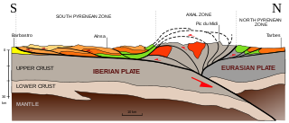
The Pyrenees are a 430-kilometre-long, roughly east–west striking, intracontinental mountain chain that divide France, Spain, and Andorra. The belt has an extended, polycyclic geological evolution dating back to the Precambrian. The chain's present configuration is due to the collision between the microcontinent Iberia and the southwestern promontory of the European Plate. The two continents were approaching each other since the onset of the Upper Cretaceous (Albian/Cenomanian) about 100 million years ago and were consequently colliding during the Paleogene (Eocene/Oligocene) 55 to 25 million years ago. After its uplift, the chain experienced intense erosion and isostatic readjustments. A cross-section through the chain shows an asymmetric flower-like structure with steeper dips on the French side. The Pyrenees are not solely the result of compressional forces, but also show an important sinistral shearing.

The geology of Massachusetts includes numerous units of volcanic, intrusive igneous, metamorphic and sedimentary rocks formed within the last 1.2 billion years. The oldest formations are gneiss rocks in the Berkshires, which were metamorphosed from older rocks during the Proterozoic Grenville orogeny as the proto-North American continent Laurentia collided against proto-South America. Throughout the Paleozoic, overlapping the rapid diversification of multi-cellular life, a series of six island arcs collided with the Laurentian continental margin. Also termed continental terranes, these sections of continental rock typically formed offshore or onshore of the proto-African continent Gondwana and in many cases had experienced volcanic events and faulting before joining the Laurentian continent. These sequential collisions metamorphosed new rocks from sediments, created uplands and faults and resulted in widespread volcanic activity. Simultaneously, the collisions raised the Appalachian Mountains to the height of the current day Himalayas.
The Burlington mylonite zone is a 1.5 kilometer thick mylonite zone, resulting from the dynamic recrystallization and grain size reduction of rocks, running from Weston, Massachusetts to Lynnfield, Massachusetts and Danvers, Massachusetts. The deformation that formed the zone is believed to be related to the Bloody Bluff Fault. In 1976, R. O. Castle released information indicating that the Paleozoic Early Devonian Peabody Granite intruded the mylonite zone, giving a young age limit for the formation.
The Bloody Bluff fault is the boundary between the Milford-Dedham zone and the Nashoba zone in eastern Massachusetts. It runs between Westborough, Massachusetts and Lynnfield, Massachusetts. In the south, into Connecticut, the component Lake Char fault is poorly exposed. The Bloody Bluff fault zone is 3.2 kilometers wide in Framingham, Massachusetts and forms the five kilometer wide Burlington mylonite zone to the north. Rocks along the fault have experienced both ductile and brittle deformation.

The geology of Bosnia & Herzegovina is the study of rocks, minerals, water, landforms and geologic history in the country. The oldest rocks exposed at or near the surface date to the Paleozoic and the Precambrian geologic history of the region remains poorly understood. Complex assemblages of flysch, ophiolite, mélange and igneous plutons together with thick sedimentary units are a defining characteristic of the Dinaric Alps, also known as the Dinaride Mountains, which dominate much of the country's landscape.

The geology of Luxembourg is divided into two geologic regions: Rheinisches Schiefergeblige in the north, extending into the Ardennes region in Belgium, and the Oesling Zone to the north of Ettelbruck. The country is underlain by the Hercynian orogeny related Givonne Anticlinorium, which mainly contains Early Devonian sandstone and shale. Rocks closer to the surface are primarily from the Cretaceous and are cut by the Sauer River and its tributaries.
The geology of Mongolia is made up a complicated array of microcontinents and island chains accreted together over the past half billion years, producing varied terrain and tectonics.
The geology of Thailand includes deep crystalline metamorphic basement rocks, overlain by extensive sandstone, limestone, turbidites and some volcanic rocks. The region experienced complicated tectonics during the Paleozoic, long-running shallow water conditions and then renewed uplift and erosion in the past several million years ago.
The geology of Greece is highly structurally complex due to its position at the junction between the European and African tectonic plates.
The geology of Denmark includes 12 kilometers of unmetamorphosed sediments lie atop the Precambrian Fennoscandian Shield, the Norwegian-Scottish Caledonides and buried North German-Polish Caledonides. The stable Fennoscandian Shield formed from 1.45 billion years ago to 850 million years ago in the Proterozoic. The Fennoscandian Border Zone is a large fault, bounding the deep basement rock of the Danish Basin—a trough between the Border Zone and the Ringkobing-Fyn High. The Sorgenfrei-Tornquist Zone is a fault-bounded area displaying Cretaceous-Cenozoic inversion.

The Solund Basin is a sedimentary basin containing at least 6 km of mainly coarse conglomerates of Devonian age. It is the southernmost of a group of basins of similar age found along the southwest coast of Norway between Sognefjord and Nordfjord, developed in the hanging-wall of the Nordfjord-Sogn Detachment. It was formed as a result of extensional tectonics during the post-orogenic collapse of crust thickened during the Caledonian orogeny, towards the end of the Silurian period. It is named for the municipality of Solund in Vestland.
References
- ↑ Goldsmith, Richard (1991). Structural and Metamorphic History of Eastern Massachusetts. USGS. p. H41.