Demographics
Midhirst is defined by Statistics New Zealand as a rural settlement and covers 1.82 km2 (0.70 sq mi). It is part of the wider Pembroke statistical area, which covers 226.38 km2 (87.41 sq mi). [1]
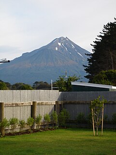
The population of Midhirst was 252 in the 2018 New Zealand census, an increase of 15 (6.3%) since the 2013 census, and an increase of 24 (10.5%) since the 2006 census. There were 129 males and 123 females, giving a sex ratio of 1.05 males per female. Ethnicities were 237 people (94.0%) European/Pākehā, 36 (14.3%) Māori, 6 (2.4%) Pacific peoples, and 3 (1.2%) Asian (totals add to more than 100% since people could identify with multiple ethnicities). Of the total population, 51 people (20.2%) were under 15 years old, 45 (17.9%) were 15–29, 120 (47.6%) were 30–64, and 36 (14.3%) were over 65. [2]
Taranaki is a region in the west of New Zealand's North Island. It is named after its main geographical feature, the stratovolcano of Mount Taranaki, also known as Mount Egmont.

The Second Taranaki War is a term used by some historians for the period of hostilities between Māori and the New Zealand Government in the Taranaki district of New Zealand between 1863 and 1866. The term is avoided by some historians, who either describe the conflicts as merely a series of West Coast campaigns that took place between the Taranaki War (1860–1861) and Titokowaru's War (1868–69), or an extension of the First Taranaki War.

Inglewood is a town in the Taranaki Region of New Zealand's North Island. It is 16 kilometres (10 mi) southeast of New Plymouth on State Highway 3, close to Mount Taranaki, and sits 200 metres (660 ft) above sea level. The town services a mainly dairy farming region.
Eltham is a small inland town in South Taranaki, New Zealand, located 50 kilometres (31 mi) south of the city of New Plymouth and southeast of the volcanic cone of Mount Taranaki/Egmont. Stratford is 11 kilometres (6.8 mi) north, Kaponga 13 km west, and Hāwera is 19 km (12 mi) south. State Highway 3 runs through the town.

Waitara is a town in the northern part of the Taranaki region of the North Island of New Zealand. Waitara is located just off State Highway 3, 15 kilometres (9.3 mi) northeast of New Plymouth.
Hāwera is the second-largest centre in the Taranaki region of New Zealand's North Island, with a population of 10,300. It is near the coast of the South Taranaki Bight. The origins of the town lie in a government military base that was established in 1866, and the town of Hāwera grew up around a blockhouse in the early 1870s.
South Taranaki is a territorial authority on the west coast of New Zealand's North Island that contains the towns of Hāwera, Manaia, Ōpunake, Patea, Eltham, and Waverley. The District has a land area of 3,575.46 km² and a population of 28,700. It is part of the greater Taranaki Region.
Taranaki Rugby, previously the Taranaki Rugby Football Union, is the governing body for rugby union in Taranaki, New Zealand; Taranaki is a region of New Zealand that covers areas in the districts of New Plymouth and South Taranaki. Established in 1889, they represent the Mitre 10 Cup side, Taranaki Bulls, and Farah Palmer Cup side, Taranaki Whio. It is also affiliated with the Chiefs Super Rugby franchise. Their home playing colours are amber and black and they play their home games at TET Stadium & Events Centre in Inglewood.
Kaponga is a small town in the southern part of the Taranaki region of New Zealand. It is known as "The Gateway to Dawson's Falls" on Mount Taranaki. Kaponga is located inland from Manaia and Eltham, and is on the main road connecting Eltham to Ōpunake. Ōpunake is 26 kilometres (16 mi) to the west and Eltham is 13 km to the east. Auroa lies to the south-east. Manaia is 15 kilometres (9 mi) south of Kaponga.
Urenui is a settlement in northern Taranaki, in the North Island of New Zealand. It is located on State Highway 3 close to the shore of the North Taranaki Bight, 13 kilometres east of Waitara and 6 km south-west of Mimi. The Urenui River flows past the settlement into the North Taranaki Bight.
Tongapōrutu is a settlement in northern Taranaki, in the North Island of New Zealand. It is located on State Highway 3 at the mouth of the Tongaporutu River, 15 kilometres south of Mokau. Tongapōrutu is well known in New Zealand for its 'Three Sisters' rock formations and its Māori petroglyphs carved into cave rock walls. However, both the Māori rock carvings and the 'Three Sisters formations are constantly being eroded by the Tasman Sea.
Awakino is a settlement in the south of Waitomo District, in the North Island of New Zealand. It is located on State Highway 3 at the mouth of the Awakino River, five kilometres north of Mokau. It is 79 km southwest of Te Kuiti, and 98 km northeast of New Plymouth.

State Highway 3 (SH 3) is one of New Zealand's eight national state highways. It serves the west coast of the country's North Island and forms a link between State Highway 1 and State Highway 2. Distances are measured from north to south.
The Taranaki Waste Lands Board was constituted under the Taranaki Waste Lands Act 1874 to manage the sale of confiscated Māori land.
Auroa is a locality in southern Taranaki. Opunake is to the west, Kaponga to the northeast, and Manaia to the southeast. Mount Taranaki is directly north of Auroa.
Mangatoki is a locality in southern Taranaki, in New Zealand's North Island. Eltham is to the east, Kaponga to the west and Matapu to the south. The Mangatoki Stream runs from Mount Taranaki through the area and into the Waingongoro River.
The Waitara Branch is a branch line railway 7.245 km long in the Taranaki region of New Zealand's North Island. It was built as part of the region's first railway, linking New Plymouth with the closest suitable port, then the river port of Waitara. In 1884 the Breakwater port was opened in New Plymouth, but the line was saved when a (meat) freezing works was opened at Waitara in 1885.

Stratford District is a territorial authority district in the North Island of New Zealand. The Stratford District Council is headquartered in the only town, Stratford. The district is divided between the Manawatū-Whanganui region and the Taranaki region.
