
Haram is a municipality in Møre og Romsdal county, Norway. It is part of the Sunnmøre region. The administrative center is Brattvåg, the industrial center of Sunnmøre. Other important villages in the municipality include Austnes, Eidsvik, Helle, Longva, Hildrestranda, Søvik, Tennfjord, and Vatne.

Vestnes is a municipality in Møre og Romsdal county, Norway. Vestnes is part of the traditional district of Romsdal. The administrative centre of the municipality is the village of Vestnes. Other villages in the municipality include Vikebukt, Vik, Øverås, Fiksdal, Tomrefjord, and Tresfjord.

Midsund is a municipality in Møre og Romsdal county, Norway. It is part of the Romsdal region. The administrative centre is the village of Midsund on Otrøya island. Other settlements on the island include Uglvik and Raknes in the north and Nord-Heggdal in the southeast.

Tranøy is a municipality in Troms county, Norway. The municipality is situated on the southern coast of the large island of Senja. The administrative centre is the village of Vangsvik in the eastern part of the municipality. Other important villages include Stonglandseidet, Skrollsvika, and Å.

The Midsund Bridge is a reinforced concrete arch bridge that crosses the Midsundet strait between the islands of Otrøya and Midøya in Midsund Municipality, Møre og Romsdal county, Norway. The 408-metre-long (1,339 ft) bridge runs between the village of Midsund on Otrøya island to Leirvika on Midsøya island. The bridge opened on 28 June 1969 and cost 2.8 million kr.

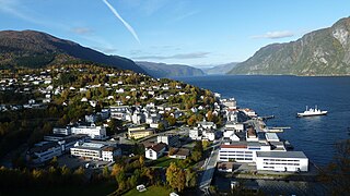
Vatne is a village and former municipality in Haram Municipality in Møre og Romsdal county, Norway. The village of Vatne is located at the southern end of the Vatnefjorden in the eastern part of Haram Municipality. The 1.64-square-kilometre (0.63 sq mi) village has a population (2013) of 1,876 which gives it a population density of 1,144 inhabitants per square kilometre (2,960/sq mi). Other villages in the Vatne area include Eidsvik and Tennfjord to the south of the village of Vatne and Helle to the north of it.
Romsdalsfjord or Romsdal Fjord is the ninth-longest fjord in Norway. It is 88 kilometres (55 mi) long and located in the Romsdal district of Møre og Romsdal county. It flows through the municipalities of Midsund, Haram, Vestnes, Molde, Nesset, and Rauma. The deepest point in the fjord is just southwest of the town of Molde, where it is 550 metres (1,800 ft) deep. Romsdalsfjord is a threshold-fjord, as it is separated from the ocean by shallower areas at the mouth. Several islands and skerries also shelter the wide central fjord from the Atlantic.
Sør-Aukra is a former municipality in Møre og Romsdal county, Norway. Sør Aukra Municipality existed from 1924 until 1965 when it was all merged into Midsund Municipality. The municipality consisted of the entire island of Otrøya, the eastern part of Midøya island, and some small surrounding islands at the entrance to Romsdal Fjord. The village of Midsund was the administrative centre of the municipality.

Bremangerlandet is an island in Bremanger Municipality in the traditional district of Nordfjord in Sogn og Fjordane county, Norway. The 153-square-kilometre (59 sq mi) island is the largest island in the county. The highest point on the island is the 889-metre (2,917 ft) tall mountain Svartevassegga, however the cliff at Hornelen, located 1 kilometre (0.62 mi) to the east, is more well-known and has an elevation of 860 metres (2,820 ft). The 4-kilometre (2.5 mi) long lake Dalevatnet is located in the central part of the island.
Hollingen is a village in Aukra Municipality in Møre og Romsdal county, Norway. It is located on the Romsdal peninsula along the Julsundet strait about 15 kilometres (9.3 mi) northwest of the city of Molde. The 0.38-square-kilometre (94-acre) village has a population (2013) of 558. This gives it a population density of 1,468 inhabitants per square kilometre (3,800/sq mi).

Harøya is a swampy island in Sandøy Municipality in Møre og Romsdal county, Norway. At 13.6 square kilometres (5.3 sq mi), it is the largest island in the municipality. The island is located between the islands of Finnøya and Fjørtofta.
Midøya is an island in Midsund Municipality in Møre og Romsdal county, Norway. The 13.6-square-kilometre (5.3 sq mi) island sits at the entrance to the Romsdalsfjorden between the islands of Dryna and Otrøya. Until 1965, the island was divided between the municipalities of Sør-Aukra and Vatne. The Midsund Bridge connects this island to the village of Midsund on the neighboring island of Otrøya.
Julsundet is a 15-kilometre (9.3 mi) long strait connecting the Norwegian Sea to the Romsdalsfjorden. The strait is located about 10 kilometres (6.2 mi) west of the town of Molde in Møre og Romsdal county, Norway. The strait runs through the municipalities of Fræna, Aukra, Molde, and Midsund. The strait flows north-south from the village of Bud to Julneset. It flows between the Romsdal peninsula and the islands of Otrøya and Gossa. The Frænfjorden empties into the Julsundet strait at the small island of Vågøy.
Nord-Heggdal is a village in Midsund Municipality in Møre og Romsdal county, Norway. It is located about 15 kilometres (9.3 mi) southwest of the town of Molde on the south side of Otrøya island, along Romsdal Fjord. The village of Midsund lies about 15 kilometres (9.3 mi) to the west of Nord-Heggdal. The Nord-Heggdal Chapel is located here.
Stranda is the administrative centre of Stranda Municipality in Møre og Romsdal county, Norway. The village is located on the western shore of the Storfjorden. The 2.38-square-kilometre (590-acre) village has a population (2013) of 2,907; giving the village a population density of 1,221 inhabitants per square kilometre (3,160/sq mi), and making it the largest settlement in the municipality.

Otrøy Church is a parish church in Midsund Municipality in Møre og Romsdal county, Norway. It is located in the village of Uglvik, a couple of kilometers northeast of the village of Midsund on the island of Otrøya. The church is part of the Midsund parish in the Molde arch-deanery in the Diocese of Møre. The white wooden church was built in 1878 by the architect Jacob Wilhelm Nordan. The church seats about 300 people. This was the main church of the old Sør-Aukra municipality, and at that time it was called Sør-Aukra church.
Nord-Heggdal Chapel is a parish church in Midsund Municipality in Møre og Romsdal county, Norway. It is located in the village of Nord-Heggdal on the southeastern shore of the island of Otrøya. The church is part of the Midsund parish in the Molde arch-deanery in the Diocese of Møre. The brown, wooden church was built in 1974 by the architect Jostein Heggdal. The church seats about 100 people.

Selje is the administrative centre of Selje Municipality in Sogn og Fjordane county, Norway. The village is located at the southwestern base of the Stadlandet peninsula at the entrance to the Moldefjorden. The village lies about 17 kilometres (11 mi) northeast of the town of Måløy and about 65 kilometres (40 mi) southwest of the town of Ålesund. The small island of Selja lies just off the coast of the village. The 0.65-square-kilometre (160-acre) village has a population (2013) of 651, giving the village a population density of 1,002 inhabitants per square kilometre (2,600/sq mi). Selje Church is located in the village.

Årås is the administrative centre of Austrheim municipality in Hordaland county, Norway. The village is located in the central part of the island of Fosnøyna, about 2 kilometres (1.2 mi) northeast of the village of Austrheim. The 0.64-square-kilometre (160-acre) village has a population (2013) of 603, giving the village a population density of 942 inhabitants per square kilometre (2,440/sq mi).


