
Range Regional Airport is a public use airport located four nautical miles southeast of the central business district of Hibbing, in Saint Louis County, Minnesota, United States. It was formerly known as Chisholm-Hibbing Airport or Chisholm-Hibbing Municipal Airport. The airport is mostly used for general aviation but is also served by one commercial and one charter airline. Scheduled passenger service is subsidized by the Essential Air Service program.

Charlevoix Municipal Airport is a city-owned, public-use airport located one nautical mile (2 km) southwest of the central business district of Charlevoix, a city in Charlevoix County, Michigan, United States. It is mostly used for general aviation, but also offers passenger service to Beaver Island via Island Airways and Fresh Air Aviation.
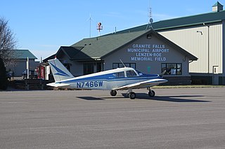
Granite Falls Municipal Airport, also known as Lenzen-Roe Memorial Field, is a public-use airport in Yellow Medicine County, Minnesota, United States. It is owned by the City of Granite Falls and located four nautical miles (7 km) south of its central business district. The airport is situated near State Highway 23.
Longville Municipal Airport is a city-owned public-use airport located one nautical mile (1.85 km) northeast of the central business district of Longville, a city in Cass County, Minnesota, United States.
Forest City Municipal Airport is a public use airport in Hancock County, Iowa, United States. It is located two nautical miles (4 km) south of the central business district of Forest City, a city in Hancock County and Winnebago County. The airport is owned by the City of Forest City. It serves general aviation for Forest City and the surrounding area. Winnebago Industries operates an IAI Astra for company use with the 5800 runway. There is no scheduled air service.
Sky Harbor Airport & Seaplane Base or Sky Harbor Airport is a public airport in Duluth, Minnesota, United States. It is located near the Wisconsin border, between Superior Bay and Lake Superior. The airport is six nautical miles (11 km) southeast of the central business district of Duluth, Minnesota, on Minnesota Point within its city limits.

Grand Marais/Cook County Airport is a county-owned public-use airport located eight miles (13 km) northwest of the central business district of Grand Marais, a city in Cook County, Minnesota, United States. This airport replaced the former Devil's Track Municipal Airport located on the shore of Devil's Track Lake, one mile (1.6 km) south of the current airport.
Cambridge Municipal Airport is a city-owned public-use airport located two miles (3 km) southwest of the central business district of Cambridge, a city in Isanti County, Minnesota, United States.
Tower Municipal Airport is a city-owned public-use airport located one nautical mile (2 km) northwest of the central business district of Tower, a city in Saint Louis County, Minnesota, United States. It is located on Lake Vermilion and is also known as Tower Municipal Airport & Seaplane Base.
Aitkin Municipal Airport, also known as Steve Kurtz Field, is a public use airport located two nautical miles (4 km) northeast of the central business district of Aitkin, a city in Aitkin County, Minnesota, United States. It is owned by the County & City of Aitkin.
Fairmont Municipal Airport is a city-owned public-use airport located two nautical miles (3.7 km) southeast of the central business district of Fairmont, a city in Martin County, Minnesota, United States.
Alexandria Municipal Airport, also known as Chandler Field, is a city-owned public-use airport located two nautical miles (3.7 km) southwest of the central business district of Alexandria, a city in Douglas County, Minnesota, United States.
Long Prairie Municipal Airport, also known as Todd Field or Todd Field Airport, is a public use airport located four nautical miles (7 km) south of the central business district of Long Prairie, a city in Todd County, Minnesota, United States. The airport is owned by Todd County and the City of Long Prairie.
Orr Regional Airport is a city-owned public-use airport located three nautical miles (6 km) southwest of the central business district of Orr, a city in Saint Louis County, Minnesota, United States.
Red Wing Regional Airport is a city-owned public-use airport located in Pierce County, Wisconsin, three nautical miles (6 km) northeast of the central business district of Red Wing, a city in Goodhue County, Minnesota, United States.

Stanton Airfield is a public use airport located one nautical mile (1.85 km) east of the central business district of Stanton, in Goodhue County, Minnesota, United States. The airport is privately owned by Stanton Sport Aviation, Inc.
Litchfield Municipal Airport is a city-owned public-use airport located two nautical miles southeast of the central business district of Litchfield, a city in Meeker County, Minnesota, United States. The airport at this location opened in 1987. The original Litchfield Airport was closer to town and was located near the County Fair Grounds.

Princeton Municipal Airport is a city-owned public-use airport located one nautical mile southwest of the central business district of Princeton, a city in Mille Lacs County, Minnesota, United States. This airport is included in the FAA's National Plan of Integrated Airport Systems 2015–2019, which categorizes it as a general aviation airport.
The Le Sueur Municipal Airport is an airport on the south side of Le Sueur, Minnesota, United States. It is located on Minnesota State Highway 112. The airport hosts a variety of events, including fly-ins and pancake breakfasts.
Wells Municipal Airport is a city-owned, public-use airport located three nautical miles (6 km) west of the central business district of Wells, a city in Faribault County, Minnesota, United States.

