Related Research Articles
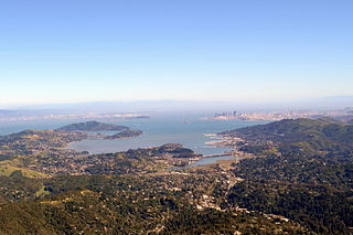
Richardson Bay is a shallow, ecologically rich arm of San Francisco Bay, managed under a Joint Powers Agency of four northern California cities. The 911-acre (369 ha) Richardson Bay Sanctuary was acquired in the early 1960s by the National Audubon Society. The bay was named for William A. Richardson, early 19th century sea captain and builder in San Francisco. It contains both Strawberry Spit and Aramburu Island.

Sonoma Creek is a 33.4-mile-long (53.8 km) stream in northern California. It is one of two principal drainages of southern Sonoma County, California, with headwaters rising in the rugged hills of Sugarloaf Ridge State Park and discharging to San Pablo Bay, the northern arm of San Francisco Bay. The watershed drained by Sonoma Creek is roughly equivalent to the wine region of Sonoma Valley, an area of about 170 square miles (440 km2). The State of California has designated the Sonoma Creek watershed as a “Critical Coastal Water Resource”. To the east of this generally rectangular watershed is the Napa River watershed, and to the west are the Petaluma River and Tolay Creek watersheds.

Spring Creek, in Sonoma County, California, is a 6.0-mile-long (9.7 km) stream that rises in the northern part of the Sonoma Mountains within Annadel State Park, draining the western slopes of Taylor Mountain and feeding into Matanzas Creek at Doyle Community Park below the Matanzas Creek Reservoir.

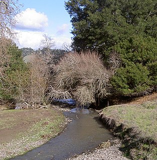
Arroyo Corte Madera del Presidio is a 4.1-mile-long (6.6 km) year-round stream in southern Marin County, California, United States. This watercourse is also known as Corte Madera Creek, although the actual stream of that name flows into San Francisco Bay further north at Point San Quentin. This watercourse has a catchment basin of about 8 square miles (21 km2) and drains the south-eastern slopes of Mount Tamalpais and much of the area in and around the town of Mill Valley; this stream discharges to Richardson Bay.

Branciforte Creek is a 5.8-mile (9.3 km) long watercourse in Santa Cruz County, California, United States. Branciforte Creek rises on the western slopes of the Santa Cruz Mountains and discharges to the San Lorenzo River, which in turn empties into the Pacific Ocean. Within the State of California Branciforte Creek is classified within the Central Coast Basin. As of the year 2002, the State of California has designated Branciforte Creek as impaired with respect to turbidity and pathogens. The Branciforte watershed consists of 6,231 acres (25.22 km2), approximately 70 percent of which is covered with mixed evergreen forest, conifer forest and other undisturbed habitats.

Zayante Creek is a 10.3-mile-long (16.6 km) stream within the San Lorenzo River watershed in Santa Cruz County, California, United States. The U.S. government has designated Zayante Creek as impaired with respect to sediment. Lompico Creek, a tributary of Zayante Creek, is listed for impairment by pathogens. In the period 1998 to 2000 a restoration project was conducted for this stream to improve anadromous fish passage, rearing and spawning. There has been a permanent U.S. Geological Survey gauging station on Zayante Creek which has operated since the year 1959; the mean altitude of the Zayante Basin, carved within the western slopes of the Santa Cruz Mountains, is 1,000 feet (300 m). Significant tributaries to Zayante Creek are Lompico Creek and Bean Creek.

Strawberry Lagoon is an inlet within Richardson Bay, Marin County, California, United States. This location, particularly on Strawberry Spit, is a winter haul-out area for the Harbor seal. Pressures of urban development at Strawberry Point along with increases in small boat traffic have diminished the use of this lagoon for seal haul out, noted as early as 1990.
Crane Creek is a stream in Sonoma County, California, United States which rises in the northern Sonoma Mountains. This watercourse flows through Crane Canyon and the Crane Creek Regional Park situated on the northwestern flank of Sonoma Mountain. Crane Creek forms a confluence with Hinebaugh Creek in the city of Rohnert Park; thereafter, the channelized Hinebaugh Creek flows westerly to discharge to the Laguna de Santa Rosa. Hiking access to the upper Crane Creek reaches is from Roberts Road off Petaluma Hill Road.
Strawberry Spit is a small artificial island in the San Francisco Bay's Richardson's Bay embayment of Strawberry Lagoon. It is still referred to as Strawberry Spit, although it no longer is technically a spit.
Bothin Marsh is a 106-acre wetland in Marin County, California. Parts of the wetlands are in the Bothin Marsh Open Space Preserve, a regional park.

Belvedere Island is a rocky island in the San Francisco Bay in Marin County, California which was formerly separated by a marsh from the mainland, though has since been linked by two spits. Part of the town of Belvedere, California is located on the island.
The Raccoon Strait is a waterway of the San Francisco Bay between Angel Island and the Tiburon Peninsula, mainland Marin County, California. During the ice ages, when sea levels were considerably lower and San Francisco Bay was a grassy valley, the combined Sacramento-San Joaquin river flowed through what is now Raccoon Strait before flowing through the canyon at the Golden Gate.

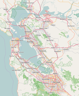
The Tiburon Peninsula is a landform of the San Francisco Bay Area's Marin County and is home to the incorporated municipalities of Tiburon, Belvedere, and a portion of Corte Madera, California. Much of the peninsula is unincorporated, including portions of the north side and the communities of Paradise Cay and Strawberry. Richardson Bay separates the peninsula from the Marin County mainland. Angel Island lies app. 1 mile south of the peninsula's southern tip. Much of the land area of the Tiburon Peninsula was part of a Spanish land grant originally given to the early Californian John Reed. A prominent feature of the Tiburon Peninsula is Ring Mountain, Marin County, which forms the backbone of the peninsula and is the highest elevation of the peninsula. The Tiburon Peninsula is the location of a number of rare and endangered flora species, and is also the site of ancient Native American rock carvings. The mineral lawsonite was first described from an occurrence on the Tiburon Peninsula.

Paradise Cay, also known as County Service Area No. 29, is an unincorporated enclave, surrounded by the town of Tiburon in Marin County, California, located 2 miles (3 km) south of Point San Quentin at an elevation of 23 feet. The waterfront community lies at the foot of the Tiburon Peninsula south of Corte Madera Creek along San Francisco Bay. The community is in ZIP code 94920 and area code 415.
Pescadero Creek is a major stream in Santa Cruz and San Mateo counties in California, United States. At 26.6 miles (42.8 km), it is the longest stream in San Mateo County and flows all year from springs in the Santa Cruz Mountains. Its source is at 1,880 feet (570 m) above sea level on the western edge of Castle Rock State Park, with additional headwaters in Portola Redwoods State Park, and its course traverses Pescadero Creek County Park and San Mateo County Memorial Park before entering Pescadero Marsh Natural Preserve at Pescadero State Beach and thence to the Pacific Ocean 14.4 miles (23 km) south of Half Moon Bay.

The Lyford House is a Victorian house located in Tiburon, California. Built in 1876, the house is listed on the National Register of Historic Places.
Morro Creek is a coastal stream in San Luis Obispo County, in the central region of the U.S. state of California. The watercourse flows from the Santa Lucia Mountains to discharge into the Pacific Ocean, at its mouth on Estero Bay, near the city of Morro Bay.

Triangle Marsh is a wetland of the San Francisco Bay, situated at the base of Ring Mountain at the north end of the Tiburon Peninsula in Marin County, California.
Pine Point is a cape landform in Richardson Bay, Marin County, California near the town of Sausalito. There was an early 1900 rail line in operation in the vicinity of Pine Point. Pine Point was an area of early twentieth century residential land use, prior to the construction of Liberty ships in the local area.

Old Mill Creek is a 2.3-mile-long (3.7 km) year-round stream in southern Marin County, California, United States. Old Mill Creek is a tributary to Arroyo Corte Madera del Presidio, which, in turn, flows to Richardson Bay at Mill Valley's municipal Bayfront Park and 106 acres (0.43 km2) Bothin Marsh.
References
- Andrea Schulte-Peevers and Sara Benson. 2006. California, Lonely Planet Publications