Triangle Marsh

Last updated
Triangle Marsh in summer 2016 Triangle Marsh in July 2016.jpg
Triangle Marsh in summer 2016

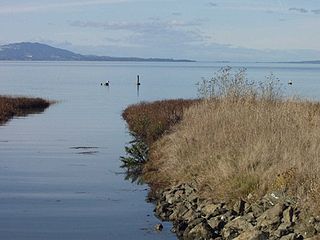
Triangle Marsh is a wetland of the San Francisco Bay, situated at the base of Ring Mountain at the north end of the Tiburon Peninsula in Marin County, California. [1]

San Francisco Bay bay on the California coast of the United States

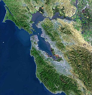
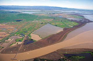
San Francisco Bay is a shallow estuary in the US state of California. It is surrounded by a contiguous region known as the San Francisco Bay Area, and is dominated by the large cities of San Jose, San Francisco and Oakland.

Ring Mountain (California) mountain in United States of America

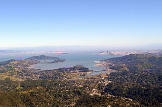
Ring Mountain is an elevated landform on the Tiburon Peninsula in Marin County, California. This mountain was named for George E. Ring, who served as a Marin County Supervisor from 1895 to 1903.

Tiburon Peninsula region and peninsula in Haïti

The Tiburon Peninsula, or simply "the Tiburon", is a region of Haiti encompassing most of Haiti's southern coast. It starts roughly at the southernmost of the Haiti-Dominican Republic border and extends westward near Cuba, forming a large headland. Four of Haiti's ten departments are located entirely within the region. They are the departments of Grand'Anse, Nippes, Sud, and Sud-Est. A large part of Ouest department is also located in the region, with the capital, Port-au-Prince serving as the line of demarcation between central Haiti and the south. The biological hot-spot of the Massif de la Hotte is located in the region in which various endemic species on the island originate.

Contents

Archaeological Pecked curvilinear nucleated petroglyphs, and recovery on Ring Mountain, hold significant evidence of Native American habitation and likely proof that early Miwok peoples exploited marine resources from Triangle Marsh. [2]

Archaeology, or archeology, is the study of human activity through the recovery and analysis of material culture. The archaeological record consists of artifacts, architecture, biofacts or ecofacts and cultural landscapes. Archaeology can be considered both a social science and a branch of the humanities. In North America archaeology is a sub-field of anthropology, while in Europe it is often viewed as either a discipline in its own right or a sub-field of other disciplines.

Pecked curvilinear nucleated

Pecked curvilinear nucleated, (PCN) in archaeology, is a form of prehistoric rock carving. The term was originally proposed by Teresa Miller and Reed Haslam in 1976 to describe a widespread type of rock carving in western North America. The form is characterized by a circular or oval groove element, which results in a raised center area. The form is quite prevalent in California and is applied to a number of Native American rock carving sites in this portion of the United States.

Petroglyph pictogram and logogram images carved on a rock surface

Petroglyphs are images created by removing part of a rock surface by incising, picking, carving, or abrading, as a form of rock art. Outside North America, scholars often use terms such as "carving", "engraving", or other descriptions of the technique to refer to such images. Petroglyphs are found worldwide, and are often associated with prehistoric peoples. The word comes from the Greek prefix petro-, from πέτρα petra meaning "stone", and γλύφω glýphō meaning "to carve", and was originally coined in French as pétroglyphe.

The 31-acre (130,000 m2) property is owned by the Marin branch of the National Audubon Society who restored upland and wetland habitats there with funding from a variety of sources. Federal endangered species, including the clapper rail and salt marsh harvest mouse, live in the Marsh.

National Audubon Society non-profit organisation in the USA

The National Audubon Society (Audubon) is a non-profit environmental organization dedicated to conservation. Located in the United States and incorporated in 1905, Audubon is one of the oldest of such organizations in the world and uses science, education and grassroots advocacy to advance its conservation mission. It is named in honor of John James Audubon, a Franco-American ornithologist and naturalist who painted, cataloged, and described the birds of North America in his famous book Birds of America published in sections between 1827 and 1838.

Clapper rail species of bird

The clapper rail is a member of the rail family, Rallidae. The taxonomy for this species is confusing and still being determined. The Ridgway's rail and the mangrove rail have been recently split. Furthermore, some taxonomists consider that the king rail and Aztec rail should be considered within this group, as those birds look similar and the birds are known to interbreed where they share territories.

Salt marsh harvest mouse species of mammal

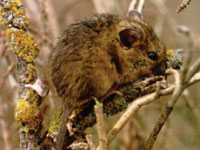
The salt marsh harvest mouse, also known as the red-bellied harvest mouse and sometimes called the saltmarsh harvest mouse, is an endangered rodent endemic to the San Francisco Bay Area salt marshes in California. There are two distinct subspecies, both endangered and listed together on federal and state endangered species lists. The northern subspecies is lighter in color and inhabits the northern marshes of the bay, and the southern subspecies lives in the East and South Bay marshes. They are both quite similar in appearance to their congener species, the [Western harvest mouse, R. megalotis], to which they are not closely related. Genetic studies of the northern subspecies have revealed that the salt marsh harvest mouse is most closely related to the plains harvest mouse, R. montanus,, which occurs now in the Midwest]. Its endangered designation is due to its limited range, historic decline in population and continuing threat of habitat loss due to development encroachment at the perimeter of San Francisco Bay.

See also

Related Research Articles

Bolinas Lagoon lagoon in California

Bolinas Lagoon is a tidal estuary, approximately 1,100 acres (4.5 km2) in area, located in the West Marin region of Marin County, California, United States, adjacent to the town of Bolinas. It is a part of the Greater Farallones National Marine Sanctuary and is considered to be among the possible landing spots of Sir Francis Drake on the west coast of North America in 1579.

Sears Point landform in Sonoma County, California

Sears Point is a prominent landform that juts into the San Pablo Bay in Sonoma County, California, United States. This hill is the southernmost peak of the Sonoma Mountains and forms the southwestern ridge above Tolay Lake. Starting with European settlement of this area in the mid-19th century considerable modification of the Napa Sonoma Marsh began to occur, such that in contemporary times, there is considerable upland between Sears Point and San Pablo Bay. Numerous local conservation organizations are presently working to restore hundreds of acres of these historic tidal wetlands as part of the Sears Point Wetlands and Watershed Restoration Project. The region can be accessed via State Route 37 or State Route 121.

Richardson Bay arm of San Francisco Bay

Richardson Bay is a shallow, ecologically rich arm of San Francisco Bay, managed under a Joint Powers Agency of four northern California cities. The 911-acre (369 ha) Richardson Bay Sanctuary was acquired in the early 1960s by the National Audubon Society. The bay was named for William A. Richardson, early 19th century sea captain and builder in San Francisco.

Zayante Creek is a 10.3-mile-long (16.6 km) stream within the San Lorenzo River watershed in Santa Cruz County, California, United States. The U.S. government has designated Zayante Creek as impaired with respect to sediment. Lompico Creek, a tributary of Zayante Creek, is listed for impairment by pathogens. In the period 1998 to 2000 a restoration project was conducted for this stream to improve anadromous fish passage, rearing and spawning. There has been a permanent U.S. Geological Survey gauging station on Zayante Creek which has operated since the year 1959; the mean altitude of the Zayante Basin, carved within the western slopes of the Santa Cruz Mountains, is 1,000 feet (300 m). Significant tributaries to Zayante Creek are Lompico Creek and Bean Creek.

Waterbird Regional Preserve is a 192 acres (0.78 km2) regional park located in Contra Costa County, California, adjacent to the city of Martinez, CA. It is part of the East Bay Regional Park District (EBRPD). It primarily consists of an area known as McNabney Marsh, which lies alongside Interstate 680 near the Sacramento-San Joaquin Delta and between two large and active oil refineries. The marsh drains into Suisun Bay via Peyton Slough. The area provides habitat for a wide variety of waterfowl and shorebirds for resting and feeding.

Hamilton Wetland Restoration Project

The Hamilton Wetland Restoration Project, now known as the Hamilton/Bel Marin Keys Wetlands Restoration is a wetlands habitat restoration project at the former Hamilton Air Force Base—Hamilton Army Airfield (1930−1988) site and adjacent Bel Marin Keys shoreline, in Marin County, California.

Strawberry Lagoon

Strawberry Lagoon is an inlet within Richardson Bay, Marin County, California, United States. This location, particularly on Strawberry Spit, is a winter haul-out area for the Harbor seal. Pressures of urban development at Strawberry Point along with increases in small boat traffic have diminished the use of this lagoon for seal haul out, noted as early as 1990.

Stege Marsh, also known as the South Richmond Marshes, is a tidal marshland wetlands area in Richmond, California in western Contra Costa County.

Hoffman Marsh is a wetlands on San Francisco Bay in Richmond, California. The marsh has been protected within Eastshore State Park, and adjacent to Point Isabel Regional Shoreline. The marsh is an important nesting ground for wildfowl and stopping ground on the Pacific Flyway, as it is one of only a handful of undestroyed wetlands in the Bay Area. It borders Point Isabel Regional Shoreline and Interstate 80.

Strawberry Spit is a small artificial island in the San Francisco Bay's Richardson's Bay embayment of Strawberry Lagoon. It is still referred to as Strawberry Spit, although it no longer is technically a spit.

Bothin Marsh is a half acre wetlands in Marin County, California. Parts of the wetlands are in Bothin Marsh Open Space Preserve, a regional park.

Belvedere Island island in the United States of America

Belvedere Island is a rocky island in Marin County, California which was separated by a marsh from the mainland and has now been linked by two spits. Part of the town of Belvedere, California is located on the island.

The Raccoon Strait is a waterway of the San Francisco Bay between Angel Island and the Tiburon Peninsula, mainland Marin County, California. During the ice ages, when sea levels were considerably lower and San Francisco Bay was a grassy valley, the combined Sacramento-San Joaquin river flowed through what is now Raccoon Strait before flowing through the canyon at the Golden Gate.

Tiburon Peninsula (California)

The Tiburon Peninsula is a landform of the San Francisco Bay Area's Marin County and is home to the incorporated municipalities of Tiburon, Belvedere, and a portion of Corte Madera, California. Much of the peninsula is unincorporated, including portions of the north side and the communities of Paradise Cay and Strawberry. Richardson Bay separates the peninsula from the Marin County mainland. Angel Island lies app. 1 mile south of the peninsula's southern tip. Much of the land area of the Tiburon Peninsula was part of a Spanish land grant originally given to the early Californian John Reed. A prominent feature of the Tiburon Peninsula is Ring Mountain, Marin County, which forms the backbone of the peninsula and is the highest elevation of the peninsula. The Tiburon Peninsula is the locus of a number of rare and endangered flora species, and is also the site of ancient Native American rock carvings. The mineral lawsonite was first described from an occurrence on the Tiburon Peninsula.

Paradise Cay, California Unincorporated community in California, United States

Paradise Cay, also known as County Service Area No. 29, is an unincorporated enclave, surrounded by the town of Tiburon in Marin County, California, located 2 miles (3 km) south of Point San Quentin at an elevation of 23 feet. The waterfront community lies at the foot of the Tiburon Peninsula south of Corte Madera Creek along San Francisco Bay. The community is in ZIP code 94920 and area code 415.

Benjamin and Hilarita Lyford House

The Lyford House is a Victorian house located in Tiburon, California. Built in 1876, the house is listed on the National Register of Historic Places.

Dotson Family Marsh

The Dotson Family Marsh, formerly Breuner Marsh, is a 238-acre regional park on San Pablo Bay in the East San Francisco Bay Area city of Richmond, California, In 2009 the East Bay Regional Parks District acquired the Breuner Marsh site, adding it to Point Pinole Regional Shoreline. A habitat restoration plan for 60 acres of wetlands and 90 acres of California coastal prairie was subsequently approved.

Mill Creek is a stream in Marin County, California that is tributary to Richardson Bay. It discharges to Bothin Marsh within a northern arm of Richardson Bay. The stream is also known by the earlier name Old Mill Creek. The upper portions of the stream are associated with the Dipsea Trail.

San Joaquin Wildlife Sanctuary

The San Joaquin Wildlife Sanctuary is a 300 acres constructed wetland in Irvine, California, in the flood plain of San Diego Creek just above its outlet into the Upper Newport Bay.

References

  1. C. Morton, 2006
  2. C.M. Hogan, 2008

Coordinates: 37°55′20″N122°29′48″W / 37.922294°N 122.496657°W / 37.922294; -122.496657

Geographic coordinate system Coordinate system

A geographic coordinate system is a coordinate system that enables every location on Earth to be specified by a set of numbers, letters or symbols. The coordinates are often chosen such that one of the numbers represents a vertical position and two or three of the numbers represent a horizontal position; alternatively, a geographic position may be expressed in a combined three-dimensional Cartesian vector. A common choice of coordinates is latitude, longitude and elevation. To specify a location on a plane requires a map projection.