
Point Pinole Regional Shoreline is a regional park on the shores of the San Pablo Bay, California, in the United States. It is approximately 2,315 acres (9.37 km2) in area, and is operated by the East Bay Regional Park District. It includes the Dotson Family Marsh and the Point Pinole Lagoon and hosts the North Richmond Shoreline Festival.
The Madrona Marsh Preserve, in the city of Torrance in the South Bay region of Southern California, is a seasonal wetland with vernal pools. The 43 acres (17 ha) was a former site of oil wells and is one of the few natural areas remaining within an urban landscape.

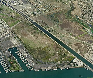
Crissy Field, a former United States Army airfield, is now part of the Golden Gate National Recreation Area in San Francisco, California, United States. Historically part of the Presidio of San Francisco, Crissy Field closed as an airfield after 1974. Under Army control, the site was affected by dumping of hazardous materials. The National Park Service took control of the area in 1994 and, together with the Golden Gate National Parks Conservancy, worked to restore the site until 2001, when the Crissy Field Center was opened to the public. While most buildings have been preserved as they were in the 1920s, some have been transformed into offices, retail space, and residences.
Cootes Paradise at the western end of Lake Ontario is a property of the Royal Botanical Gardens and a remnant of the larger 37- acre Dundas Marsh Crown Game Preserve established by the Province of Ontario in 1927.
The Ballona Wetlands State Ecological Reserve are located in Los Angeles County, California, just south of Marina del Rey and east of Playa del Rey. The natural wetlands once included the areas now taken up by Marina del Rey, New Amsterdam Canals of Venice, Playa Vista, northern Playa del Rey, and formerly extended northerly beyond Venice Boulevard to the historical Venice Canals that are now covered in asphalt with 6 streets.

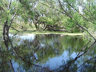
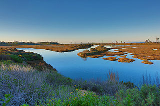
Theodore J. Hoover Natural Preserve, which includes Waddell Marsh, is located at the mouth of Waddell Creek, a coastal freshwater marsh that is one of the rarest habitats on the Central Coast of California. This marsh is one of the few relatively undisturbed bodies of fresh water left along the West coast. The land is 23 acres of wetland habitat. It is part of the Rancho del Oso Big Basin Redwoods State Park, located approximately 65 miles south of San Francisco. The elevation in the park ranges from sea level to over 2,000 feet. The area was named after William W. Waddell, who established the last of his four sawmills there in 1868. The sawmill ran down after his death in 1875. All the boilers were left in the area; they are now completely surrounded by second-growth redwoods. Other trees found in the park are conifers, and oaks. Within the park there are different vegetation types to be seen, such as chaparral, redwood forests, and riparian habitats.

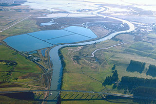
Located in northern California the Suisun Marsh has been referred to as the largest brackish water marsh on west coast of the United States of America. The marsh land is part of the San Francisco Bay tidal estuary, and subject to tidal ebb and flood. The marsh is home to many species of birds and other wildlife, and is formed by the confluence of the Sacramento and San Joaquin rivers between Martinez and Suisun City, California and several other smaller, local watersheds. Adjacent to Suisun Bay, the marsh is immediately west of the legally defined Sacramento-San Joaquin Delta as well as part of the San Francisco Bay estuary.

Ridgway's rail is a near-threatened species of bird. It is found principally in California's San Francisco Bay to southern Baja California. A member of the rail family, Rallidae, it is a chicken-sized bird that rarely flies.
The Napa Sonoma Marsh is a wetland at the northern edge of San Pablo Bay, which is a northern arm of the San Francisco Bay in California, United States. This marsh has an area of 48,000 acres (194 km2), of which 13,000 acres (53 km2) are abandoned salt evaporation ponds. The United States Government has designated 13,000 acres (53 km2) in the Napa Sonoma Marsh as the San Pablo Bay National Wildlife Refuge.
Waterbird Regional Preserve is a 192 acres (0.78 km2) regional park located in Contra Costa County, California, adjacent to the city of Martinez, CA. It is part of the East Bay Regional Park District (EBRPD). It primarily consists of an area known as McNabney Marsh, which lies alongside Interstate 680 near the Sacramento-San Joaquin Delta and between two large and active oil refineries. The marsh drains into Suisun Bay via Peyton Slough. The area provides habitat for a wide variety of waterfowl and shorebirds for resting and feeding.

Point San Pablo Harbor is a marina and small community at the far end of Point San Pablo in San Pablo Bay, within Richmond, in Contra Costa County, California. It is located at 1900 Stenmark Drive, Richmond CA 94801.
Hoffman Marsh is a wetlands on San Francisco Bay in Richmond, California. The marsh has been protected within Eastshore State Park, and adjacent to Point Isabel Regional Shoreline. The marsh is an important nesting ground for wildfowl and stopping ground on the Pacific Flyway, as it is one of only a handful of undestroyed wetlands in the Bay Area. It borders Point Isabel Regional Shoreline and Interstate 80.

Glacial Ridge National Wildlife Refuge was created on October 12, 2004, the 545th National Wildlife Refuge in the United States. Its creation was the result of cooperation between at least 30 agencies or governmental entities. The creation of the refuge was spearheaded by The Nature Conservancy, and the initial endowment of 2,300 acres (9.3 km2) of land was donated by the Conservancy. In light of its planned final size of 37,756 acres (153 km2), it is described by the US Fish and Wildlife Service as "the largest tallgrass prairie and wetland restoration project in U.S. history."
The Dotson Family Marsh, formerly Breuner Marsh, is a 238-acre regional park on San Pablo Bay in the East San Francisco Bay Area city of Richmond, California, In 2009 the East Bay Regional Parks District acquired the Breuner Marsh site, adding it to Point Pinole Regional Shoreline. A habitat restoration plan for 60 acres of wetlands and 90 acres of California coastal prairie was subsequently approved.

Triangle Marsh is a wetland of the San Francisco Bay, situated at the base of Ring Mountain at the north end of the Tiburon Peninsula in Marin County, California.
San Elijo Lagoon Ecological Reserve is one of the largest remaining coastal wetlands in San Diego County, California, United States.

Crissy Marsh is a wetland area in San Francisco, California, United States. Crissy Marsh has brackish waters, making an ideal habitat for many bird species along the Pacific Flyway. Here, freshwater runoff meets the salt water of the bay. It is 130-acres and located on the northern end of the San Francisco Peninsula. This salt marsh was largely destroyed to build Crissy Field, an airfield used during World War I and World War II. It has since been restored, with the airfield being removed. It now hosts abundant and recovering wildlife on the northern San Francisco coast.

The Palo Alto Baylands Nature Preserve, known officially as the Baylands Nature Preserve, is the largest tract of undisturbed marshland remaining in the San Francisco Bay. Fifteen miles of multi-use trails provide access to a unique mixture of tidal and fresh water habitats. The preserve encompasses 1,940 acres in both Palo Alto and East Palo Alto, and is owned by the city of Palo Alto, California, United States. It is an important habitat for migratory shorebirds and is considered one of the best birdwatching spots on the West Coast.
The Gardena Willows Wetland Preserve occupies 13.6 acres (55,000 m2) of land owned by the City of Gardena, in Los Angeles County, California. The preserve is the last intact remnant of the former Dominguez Slough, an important vernal marsh and riparian forest with riparian zones that once covered as much as 400 acres (1,600,000 m2) of this area, known as the South Bay region. The preserve has 9.4 acres (38,000 m2) of wetland and 4.2 acres (17,000 m2) of upland. The wetlands have a natural depression where water remains for such a significant time that plants and animals not adapted to water and saturated soils cannot survive. The upland, which remains dry outside of the rainy season, supports plants which thrive with these drier conditions. The slough is a part of the Dominguez Watershed, 96% of which is now covered with concrete and man-made structures. It is believed that the Tongva, the native people of this region, were able to commute by canoe around much of the area. Tongva villages were located throughout much of what is now Los Angeles and Orange Counties as well as three southern Channel Islands as distant as 60 miles from the coast of Los Angeles County.

Hooks Island is an uninhabited, approximately 36-acre (15 ha) tidal salt marsh island in San Francisco Bay, in Palo Alto, California, United States. In the 2010s, it was observed to be a home for tens of near-endangered California clapper rails.
