
The Sierra Nevada is a mountain range in the Western United States, between the Central Valley of California and the Great Basin. The vast majority of the range lies in the state of California, although the Carson Range spur lies primarily in Nevada. The Sierra Nevada is part of the American Cordillera, an almost continuous chain of mountain ranges that forms the western "backbone" of the Americas.

Inyo County is a county in the eastern central part of the U.S. state of California, located between the Sierra Nevada mountains and the state of Nevada. In the 2020 census, the population was 19,016. The county seat is Independence. Inyo County is on the east side of the Sierra Nevada and southeast of Yosemite National Park in Central California. It contains the Owens River Valley; it is flanked to the west by the Sierra Nevada and to the east by the White Mountains and the Inyo Mountains. With an area of 10,192 square miles (26,397 km2), Inyo County is the second-largest county by area in California, after San Bernardino County. Almost one-half of that area is within Death Valley National Park. However, with a population density of 1.8 people per square mile, it also has the second-lowest population density in California, after Alpine County.

James Stephen Fossett was an American businessman and a record-setting aviator, sailor, and adventurer. He was the first person to fly solo nonstop around the world in a balloon and in a fixed-wing aircraft. He made his fortune in the financial services industry and held world records for five nonstop circumnavigations of the Earth: as a long-distance solo balloonist, as a sailor, and as a solo flight fixed-wing aircraft pilot.

The Ansel Adams Wilderness is a wilderness area in the Sierra Nevada of California, United States. The wilderness spans 231,533 acres (93,698 ha); 33.9% of the territory lies in the Inyo National Forest, 65.8% is in the Sierra National Forest, and the remaining 0.3% covers nearly all of Devils Postpile National Monument. Yosemite National Park lies to the north and northwest, while the John Muir Wilderness lies to the south.

San Gorgonio Mountain, also known locally as Mount San Gorgonio, or Old Greyback, is the highest peak in Southern California and the Transverse Ranges at 11,503 feet (3,506 m).
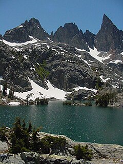
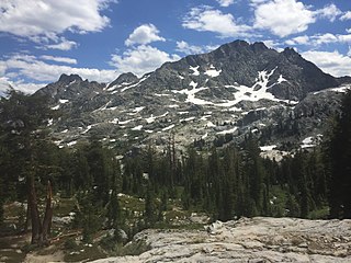
The Minarets are a series of jagged peaks located in the Ritter Range, a sub-range of the Sierra Nevada Mountains in the state of California. They are easily viewed from Minaret Summit, which is accessible by auto. Collectively, they form an arête, and are a prominent feature in the Ansel Adams Wilderness which was known as the Minaret Wilderness until it was renamed in honor of Ansel Adams in 1984.
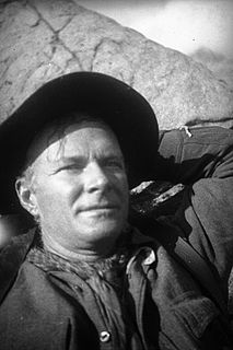
Norman Clyde was a mountaineer, mountain guide, freelance writer, nature photographer, and self-trained naturalist. He is well known for achieving over 130 first ascents, many in California's Sierra Nevada and Montana's Glacier National Park. He also set a speed climbing record on California's Mount Shasta in 1923. The Bancroft Library at the University of California, Berkeley has 1467 articles written by Clyde in its archives.

Mount Moran is a mountain in Grand Teton National Park of western Wyoming, USA. The mountain is named for Thomas Moran, an American western frontier landscape artist. Mount Moran dominates the northern section of the Teton Range rising 6,000 feet (1,800 m) above Jackson Lake. Several active glaciers exist on the mountain with Skillet Glacier plainly visible on the monolithic east face. Like the Middle Teton in the same range, Mount Moran's face is marked by a distinctive basalt intrusion known as the Black Dike.

Perlan Project Inc. is a 501(c)(3) not-for-profit aeronautical exploration and atmospheric science research organization that utilizes sailplanes (gliders) designed to fly at extremely high altitudes.
Huntington Lake is a reservoir in Fresno County, California on Big Creek, located in the Sierra Nevada at an elevation of 7000 ft. The lake receives water from Southern California Edison's Big Creek Hydroelectric Project, as well as the many streams that flow into the lake. Some water leaving the lake flows to Big Creek, while some is diverted to nearby Shaver Lake. The lake is home to a variety of recreational activities, including camping, horse-back riding, skiing, sailing, fishing and more. It is drained and refilled through the Big Creek dam system each year, with winter water levels often dipping below 50 percent of the lake's capacity.

Folsom Lake is a reservoir on the American River in the Sierra Nevada foothills of California, United States.

The Ritter Range is a small mountain range within California's Sierra Nevada. Most of the mountain range lies within the Ansel Adams Wilderness.

Airborne Real-time Cueing Hyperspectral Enhanced Reconnaissance, also known by the acronym ARCHER, is an aerial imaging system that produces ground images far more detailed than plain sight or ordinary aerial photography can. It is the most sophisticated unclassified hyperspectral imaging system available, according to U.S. Government officials. ARCHER can automatically scan detailed imaging for a given signature of the object being sought, for abnormalities in the surrounding area, or for changes from previous recorded spectral signatures.

Minaret Summit is a mountain pass on Highway 203 in the central Sierra Nevada. The pass, lying on the Madera-Mono County border, is within the Mammoth Ranger District of the Inyo National Forest and located near Devils Postpile National Monument, Mammoth Lakes, and Mammoth Mountain. The elevation of the pass is about 9,265 ft (2,824 m). Highway 203 ends at Minaret Summit. The road continues, now called Reds Meadow Road, until its dead end at the Reds Meadow Pack Station near the Rainbow Falls trailhead.

Charles Clifford Ogle was a businessman and developer in San Francisco and Oakland, California, at the time of his disappearance.

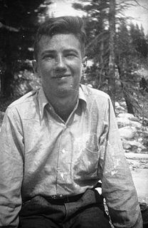
Jules Marquard Eichorn was an American mountaineer, environmentalist, and music teacher.
Vicki Cruse was an American aerobatic pilot and administrator. She won the U.S. national unlimited aerobatic title in 2007. She had been president of the International Aerobatic Club (IAC) since 2005 and was also an Experimental Aircraft Association (EAA) director and board member.
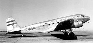
The crash of TWA Flight 8 involved a Transcontinental & Western Air Douglas DC-2. On March 1, 1938, during a scheduled passenger flight from San Francisco to Winslow, Arizona, TWA's interstate hub, the flight encountered severe weather. The pilot radioed his intention to land in nearby Fresno. The aircraft subsequently crashed on a mountain in Yosemite National Park, and was found three months later.
Glen Dawson was an American rock climber, mountaineer, antiquarian bookseller, publisher and environmentalist.
Volcanic Ridge is an 11,486-foot-elevation (3,501 meter) ridge located in the Sierra Nevada mountain range in Madera County of northern California, United States. It is situated in the Ansel Adams Wilderness on land managed by Inyo National Forest. It is set in the Ritter Range, 1.9 miles (3.1 km) southeast of Mount Ritter, and approximately 10 miles (16 km) west of the community of Mammoth Lakes. The Minarets are one mile to the west and Devils Postpile National Monument is five miles to the southeast. Topographic relief is significant as the west aspect rises over 1,700 feet (520 meters) above Iceberg Lake in approximately one-half mile.


