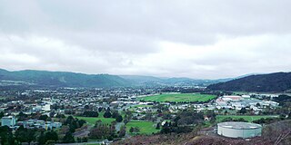
Upper Hutt is a city in the Wellington Region of New Zealand and one of the four cities that constitute the Wellington metropolitan area.
This is a timeline of environmental history of New Zealand. It includes notable events affecting the natural environment of New Zealand as a result of human activity.

Murupara is a town located in the Whakatāne District and Bay of Plenty Region of New Zealand's North Island. The town is situated in an isolated part of the region between the Kaingaroa Forest and Te Urewera protected area, on the banks of the Rangitaiki River, 65 kilometres southeast of Rotorua. Indigenous Māori also make up over 90% of the total population.
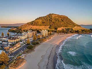
Mount Maunganui is a major residential, commercial and industrial suburb of the Tauranga metropolitan area, located on a peninsula to the north-east of Tauranga's city centre. It was an independent town from Tauranga until the completion of the Tauranga Harbour Bridge in 1988, which connects Mount Maunganui to Tauranga's central business district.

Rawene is a town on the south side of the Hokianga harbour, in Northland, New Zealand. State Highway 12 passes to the south. The town lies at the apex of a peninsula. A car ferry links it to Kohukohu and the northern Hokianga.

Queenstown-Lakes District, a local government district, is in the Otago Region of New Zealand that was formed in 1986. It is surrounded by the districts of Central Otago, Southland, Westland and Waitaki.

Te Urewera is an area of mostly forested, sparsely populated rugged hill country in the North Island of New Zealand, a large part of which is within a protected area designated in 2014, that was formerly Te Urewera National Park.
Conservation park is a type of specially protected status for land held by the Crown in New Zealand for conservation purposes. The status is set up under the Conservation Act 1987 and the parks are administered by the Department of Conservation (DoC).
The Napier-Hastings Urban Area was defined by Statistics New Zealand as a main urban area of New Zealand that was based around the twin cities of Napier and Hastings in the Hawke's Bay Region. It was defined under the New Zealand Standard Areas Classification 1992 (NZSAC92), which has since been superseded by the Statistical Standard for Geographic Areas 2018 (SSGA18).

Waiotapu is an active geothermal area at the southern end of the Okataina Volcanic Centre, just north of the Reporoa caldera, in New Zealand's Taupo Volcanic Zone. It is 27 kilometres south of Rotorua. Due to dramatic geothermal conditions beneath the earth, the area has many hot springs noted for their colourful appearance, in addition to the Lady Knox Geyser, Champagne Pool, Artist's Palette, Primrose Terrace and boiling mud pools. These can mostly be viewed through access by foot, and in addition to a paid and curated experience, naturally forming hot springs appear around the area. The geothermal area covers 18 square kilometres. Prior to European occupation the area was the homeland of the Ngati Whaoa tribe who descended from those on the Arawa waka (canoe).
Whirinaki is a small coastal settlement in Hawke's Bay, in the eastern North Island of New Zealand. It sits just north of the mouth of the Esk River, a few kilometres north of Bay View and a similar distance east of Eskdale. It lies on State Highway 2, just north of its junction with State Highway 5.
Te Pōhue is a small settlement in inland Hawke's Bay, in New Zealand's eastern North Island. It lies on State Highway 5, 31 kilometres inland from Whirinaki.

Whirinaki Te Pua-a-Tāne Conservation Park is a publicly accessible conservation park in the North Island of New Zealand. The park is centered on the town of Minginui and part of the eastern boundary flanks Te Urewera. The Whirinaki Forest is one of the world's last prehistoric rainforests.
Ngāti Whare is a Māori iwi of New Zealand. It is part of a group of tribes participating in the "treelords" Treaty of Waitangi settlement with the New Zealand government involving Central North Island forestry land and cash.

State Highway 38 is a road in the North Island of New Zealand that starts from SH 5 near Waiotapu, and ends at Wairoa, where it connects to SH 2. It is the shortest connection from the central North Island (Rotorua) to the East Coast (Gisborne), but it is not often used as such. Large parts of the road are narrow and winding, and about 74 kilometres (46 mi) of the road is unsealed. Travel on this highway takes roughly four hours.

The North Island kōkako is an endangered forest bird which is endemic to the North Island of New Zealand. It is grey in colour, with a small black mask. It has blue wattles. Because of its wattle, the bird is sometimes locally called the blue-wattled crow, although it is not a corvid.

Redwoods Forest or Redwood Memorial Grove is a forest of naturalised coastal redwood on the outskirts of Rotorua, New Zealand, adjacent to the Whakarewarewa thermal area. The 6 hectares stand of Californian redwoods is part of the larger Whakarewarewa State Forest Park, which is in turn part of the Kaingaroa Forest area.

Te Whaiti or Te Whāiti, formerly called Ahikereru, is a forested area in the Whakatāne District and Bay of Plenty Region of New Zealand's North Island. It is at the northern end of the Ahikereru valley – Minginui is at the southern end. The Whirinaki River flows through the valley.

The Lakes District Health Board was a district health board that provided healthcare to the area covered by Taupō and Rotorua districts in New Zealand. In July 2022, the Lakes DHB was merged into the national health service Te Whatu Ora.

A sanctuary area is a type of New Zealand protected area. They exist to preserve populations of important forest types, like the remnants of kauri forests in Northland.
