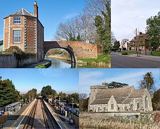
Stonehouse is a town in the Stroud District of Gloucestershire in southwestern England.

Northleach is a market town and former civil parish, now in parish Northleach with Eastington, in the Cotswold district, in Gloucestershire, England. The town is in the valley of the River Leach in the Cotswolds, about 10 miles (16 km) northeast of Cirencester and 11 miles (18 km) east-southeast of Cheltenham. The 2011 Census recorded the parish's population as 1,854, the same as Northleach built-up-area.

Adlestrop is a village and civil parish in the Cotswolds, 3 miles (5 km) east of Stow-on-the-Wold, Gloucestershire, England, on the county boundary with Oxfordshire. The River Evenlode forms the southwest boundary of the parish. The village is on a stream that flows southwest to join the river.

Hillesley is a village in Gloucestershire, England. It was transferred from the county of Avon in 1991 and is now in Stroud District. The village forms part of the civil parish of Hillesley and Tresham. It is close to the Cotswold Edge, near the Cotswold Way and about 2+1⁄2 miles (4.0 km) south of the town of Wotton under Edge.

Aston Subedge is a village and civil parish in the Cotswold district of Gloucestershire, England, close by the border with Worcestershire. According to the 2001 census the population was 55, increasing to 107 at the 2011 census. The village is about 8 miles east of Evesham, and near the village of Weston-sub-Edge.

Barnsley is a village and civil parish in the Cotswold district of Gloucestershire, England, 3.7 miles (6.0 km) northeast of Cirencester. It is 125 kilometres (78 mi) (geodesically) west of London.

Broadwell is a village and civil parish in the English county of Gloucestershire. It is about 1.5 miles (2.4 km) north of Stow-on-the-Wold, In the 2001 United Kingdom census, the parish had a population of 384. decreasing to 355 at the 2011 census.

Dumbleton is a village and civil parish in the Tewkesbury district, in the county of Gloucestershire, England. The village is roughly 20 miles from the city of Gloucester. The village is known to have existed in the time of Æthelred I who granted land to Abingdon Abbey, and it is mentioned in the Domesday Book.

Owlpen is a small village and civil parish in the Stroud district of Gloucestershire, England, set in a valley in the Cotswold hills. It is about one mile (1.6 km) east of Uley, and three miles (4.8 km) east of Dursley. The Owlpen valley is set around the settlement like an amphitheatre of wooded hills open to the west. The landscape falls within the Cotswold Area of Outstanding Natural Beauty, so designated in 1966. The population of the parish in mid-2010 was 29 (est.), the smallest in Gloucestershire.
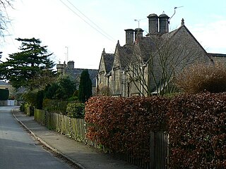
Withington is a Cotswold village and civil parish in Gloucestershire, England, about 7 miles (11 km) southeast of Cheltenham and 8 miles (13 km) north of Cirencester. The River Coln runs through the village. The parish includes the hamlets of Hilcot, Foxcote and Cassey Compton. The parish population taken at the 2011 census was 532.

Sapperton is a village and civil parish in the Cotswold District of Gloucestershire in England, about 4.5 miles (7.2 km) west of Cirencester. It is most famous for Sapperton Canal Tunnel, and its connection with the Cotswold Arts and Crafts Movement in the early 20th century. It had a population of 424, which had reduced to 412 at the 2011 census.

Coberley is a village and civil parish in the Cotswold District of Gloucestershire in England, 4 miles (6.4 km) south of Cheltenham. It lies at the confluence of several streams that form the River Churn, a tributary of the River Thames. The medieval village was closer to the main road, near a spring to the east of Coberley Court. The sites of the medieval and modern villages of Upper Coberley are a short distance to the east.

Upper Slaughter is a village in the Cotswold district of Gloucestershire, England, 4 miles (6.4 km) south west of Stow-on-the-Wold. The village lies off the A429, which is known as the Fosse Way, and is located one mile away from its twin village Lower Slaughter, as well as being near the villages Bourton-on-the-Water, Daylesford, Upper Swell and Lower Swell. As of 2021, the village had a population of 181 inhabitants, an increase of 4 from 2011.
Hatherop is a village and civil parish in the Cotswolds Area of Outstanding Natural Beauty, about 2.5 miles (4.0 km) north of Fairford in Gloucestershire, England. The River Coln forms part of the western boundary of the parish.

Leonard Stanley, or Stanley St.Leonard, is a village and parish in Gloucestershire, England, 95 miles (150 km) west of London and 3.5 miles (5.5 km) southwest of the town of Stroud. Situated beneath the Cotswold escarpment overlooking the Severn Vale, the surrounding land is mainly given over to agricultural use. The village is made up of some 600 houses and has an estimated population of 1,545 as of 2019. The hamlet of Stanley Downton lies less than a mile to the north and lies within the parish. In 1970, the village was twinned with the commune of Dozulé in the Calvados region of Normandy, northern France.

Frocester is a village and civil parish in Stroud District, Gloucestershire, England. It lies below the Cotswold escarpment, 10 miles south of Gloucester and 4 miles west of Stroud. In the 2001 census the parish had a population of 194, decreasing to 155 at the 2011 Census.

North Cerney is a village and civil parish in the English county of Gloucestershire, and lies within the Cotswolds, a range of hills designated an Area of Outstanding Natural Beauty. The village is 4 miles (6.4 km) north of Cirencester within the Churn Valley.

Miserden War Memorial is a First World War memorial in the village of Miserden, near Stroud, in Gloucestershire, south-western England. The memorial, designed by Sir Edwin Lutyens, is today a grade II listed building.

Temple Guiting is a village and civil parish in the Cotswolds, in Gloucestershire, England. The civil parish includes the smaller settlements of Barton, Farmcote, Ford and Kineton. In 2011 the parish had a population of 463.

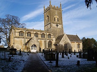
The Anglican Church of St Michael at Withington in the Cotswold District of Gloucestershire, England was built in the 12th century. It is a grade I listed building.


