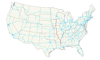
U.S. Route 65 is a north–south United States highway in the southern and midwestern United States. The southern terminus of the route is at U.S. Route 425 in Clayton, Louisiana. The northern terminus is at Interstate 35 just south of Interstate 90 in Albert Lea, Minnesota. Parts of its modern route in Iowa and historic route in Minnesota follow the old Jefferson Highway.
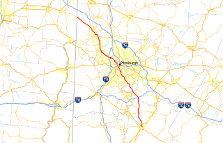
Interstate 579 (I-579) is a north–south Interstate Highway entirely within Pittsburgh, Pennsylvania. The highway is 1.57 mi (2.53 km) long. I-579 is also known as the Crosstown Boulevard since it crosses the backside of Downtown Pittsburgh.
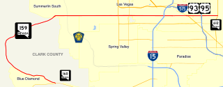
State Route 159 is a 31.204-mile (50.218 km) east–west highway in southern Nevada, providing access to Red Rock Canyon and serving as a thoroughfare in the Las Vegas metropolitan area. A portion of the west end of the route is designated a Nevada Scenic Byway.

Route 13 is a highway in Missouri which runs almost the entire north–south length of the state. Its northern terminus is at U.S. Route 69/136 in Bethany. Its southern terminus is at the Arkansas state line in downtown Blue Eye, Missouri–Arkansas where it continues as Highway 21. It is one of the original state highways of Missouri.
Route 76 is a highway in the west half of southern Missouri running between U.S. Route 60 and U.S. Route 63 at Willow Springs and the Oklahoma state line near Tiff City where it continues as a county road. It bypasses Branson on the Ozark Mountain High Road and is the namesake of the Branson strip, 76 Country Blvd. The road runs for its entirety through the Missouri Ozarks, and is at times very hilly and curvy.
Route 465 was a short highway in southern Missouri. It served the designation of the Ozark Mountain Highrooad northwest of Branson. Its northern terminus was at U.S. Route 65 north of Branson; its southern terminus was at Route 76. There were plans to eventually reconnect the route to US 65.
Route 248 is a highway in southwest Missouri. Its eastern terminus is at U.S. Route 65 in Branson. Its western terminus is at Route 76/Route 86/Route 112 in Cassville.
Route 165 and Taney County Road 165 form a loop around the west side of Branson, Missouri, in Taney and Stone counties. The highway's southern terminus is at US 65 south of Branson, in Hollister. Even though the county road designation belongs to Taney County, it briefly enters Stone County at Table Rock State Park. Upon re-entering Taney County, it crosses the Table Rock Lake Dam, along with Route 265, at Table Rock Lake. Its northern terminus is at US 65 along the Red Route in north Branson.
New York State Route 384 (NY 384) is a state highway in Western New York in the United States. It is a north–south route extending from the city of Buffalo, Erie County to the city of Niagara Falls, Niagara County, and is one of several routes directly connecting the two cities. The southern terminus of the route is at NY 5 in downtown Buffalo. NY 384's northern terminus is at the Rainbow Bridge in downtown Niagara Falls. Through its entire course in Erie County, it is known as Delaware Avenue for the street it follows in the city. In Niagara County, NY 384 follows the Niagara River and is named River Road and Buffalo Avenue.

Pennsylvania Route 987 is a state highway in the Lehigh Valley region of the U.S. state of Pennsylvania, running 10.3 mi (16.6 km) from U.S. Route 22 near the Lehigh Valley International Airport north of Allentown north to PA 946 in Klecknersville. The route begins at a cloverleaf interchange with the US 22 freeway north of Allentown in Lehigh County and heads to the east of the airport as a four-lane divided highway called Airport Road as it crosses into Northampton County. PA 987 narrows to a two-lane undivided road and continues north, becoming concurrent with PA 329 as it heads into Bath. Here, PA 329 ends and PA 987 briefly runs concurrent with PA 248 before leaving the borough. PA 987 continues northwest and serves Chapman before ending at PA 946. PA 987 was first designated in the 1930s between US 22 in Allentown and PA 946 in Klecknersville. After US 22 was relocated to its present freeway alignment in 1955, the southern terminus of PA 987 was cut back to its interchange with US 22, which used to carry Interstate 78 (I-78) as well. In the early 2000s, PA 987 was widened into a divided highway and shifted to a new alignment near the Lehigh Valley International Airport.
Mississippi Highway 9W is a 20.3-mile (32.7 km) long state highway located in northern Mississippi. The southern terminus of the route is at MS 9 north of Bruce in Calhoun County while the northern terminus is at MS 7 south of Oxford in Lafayette County. The route is a two-lane undivided road its entire length and passes through rural areas of woods and farms. Along the way, MS 9W intersects MS 315 in Paris. MS 9W was designated to follow its current alignment in 1956 and was fully paved from a gravel road by 1960.
New York State Route 101 (NY 101) is a 3.58-mile (5.76 km) long state highway in northwestern Nassau County, New York, in the United States. It runs north–south as Port Washington Boulevard from NY 25A in Flower Hill, west of Roslyn and north of Manhasset, to Astor Lane in Sands Point. It continues south along Searingtown Road to Shelter Rock Road and north on Middle Neck Road to a dead end at Long Island Sound as the unsigned County Route 101.
Pennsylvania Route 51 is a major state highway in Western Pennsylvania. It runs for 89 miles (143 km) from Uniontown to the Ohio state line near Darlington, where it connects with Ohio State Route 14. PA 51 is the termination point for Pennsylvania Route 43, Pennsylvania Route 48 and Pennsylvania Route 88. The route is a major connection from Uniontown and the rest of Fayette County to Pittsburgh.

State Route 708 (SR 708) is a short two-lane north–south state route that runs exclusively within Logan County, Ohio. The southern terminus of SR 708 approximately two miles (3.2 km) south of Russells Point at SR 235, near the Russells Point Honda manufacturing facility, and its northern terminus is just north of Russells Point at Indian Lake State Park, where the highway becomes Township Road 253 on Orchard Island.

Pennsylvania Route 48 is an 18.9-mile-long (30.4 km) state highway located in the Pittsburgh, Pennsylvania area. The route is predominantly a two-lane highway as it runs through McKeesport and other suburbs. The entire routing of PA 48 is part of the Orange Belt, both reaching their southern termini at Pennsylvania Route 51, southeast of Elizabeth. Until 1998, the northern terminus of PA 48 was at the intersection of Old Haymaker and Center Roads, about 1/2 mile from its current terminus at U.S. Route 22 Business in Monroeville.

AHighway 265 is a designation for three state highways in Northwest Arkansas. The southern segment of 19.70 miles (31.70 km) runs from Highway 170 near Strickler north to I-49/US 71/Highway 112 in south Fayetteville. A second segment begins in east Fayetteville at Highway 16 and runs north through Springdale to Highway 94 in Rogers. Further north, a third segment of 3.324 miles (5.349 km) runs from Highway 94 in Pea Ridge north to the Missouri state line. The highways are maintained by the Arkansas Department of Transportation (ARDOT).
State Route 266 (SR 266) is a 14-mile-long (23 km) east–west state highway located in the southeastern portion of Ohio. SR 266's western terminus is at an intersection with SR 377 nearly 3 1⁄2 miles (5.6 km) northwest of Stockport, and its eastern terminus is an intersection with SR 60 approximately 4 1⁄2 miles (7.2 km) northwest of Beverly.
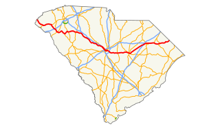
U.S. Route 76 (US 76) is an east–west U.S. highway in the U.S. state of South Carolina. Being one of the longest highways in the state, it connects the cities of Anderson, Columbia, Sumter and Florence.
State Route 114 (SR-114) is a state highway in the US state of Utah that spans 10.79 miles (17.36 km) in Utah County. The route forms a loop around US-89 and roughly parallels the coast of Utah Lake as it passes through the west side of Provo, Lindon and Orem, eventually terminating in Pleasant Grove. The highway consists of a portion of Center Street and all of Geneva Road. The highway was formed in 1931, the southern terminus initially extending into the east side of Provo. In 1965, the route was truncated to its present state.
A total of eight special routes of U.S. Route 65 exist, divided between the U.S. states of Arkansas and Missouri. Currently, they are all business loops, although a spur route in Pine Bluff, Arkansas and bypass routes in Baton Rouge, Louisiana and Springfield, Missouri both existed in the past.

