
Honduras is a country in Central America. Honduras borders the Caribbean Sea and the North Pacific Ocean. Guatemala lies to the west, Nicaragua south east and El Salvador to the south west. Honduras is the second largest Central American republic, with a total area of 112,777 square kilometres (43,543 sq mi).
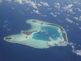
An atoll is a ring-shaped island, including a coral rim that encircles a lagoon. There may be coral islands or cays on the rim. Atolls are located in warm tropical or subtropical parts of the oceans and seas where corals can develop. Most of the approximately 440 atolls in the world are in the Pacific Ocean.

Maldives is an island country in the Indian Ocean, South Asia, south-southwest of India. It has a total land size of 298 km2 (115 sq mi) which makes it the smallest country in Asia. It consists of approximately 1,190 coral islands grouped in a double chain of 26 atolls, spread over roughly 90,000 square kilometers, making this one of the most geographically dispersed countries in the world. It has the 31st largest exclusive economic zone of 923,322 km2 (356,497 sq mi). Composed of live coral reefs and sand bars, the atolls are situated atop a submarine ridge, 960 km (600 mi) long that rises abruptly from the depths of the Indian Ocean and runs from north to south. Only near the southern end of this natural coral barricade do two open passages permit safe ship navigation from one side of the Indian Ocean to the other through the territorial waters of Maldives. For administrative purposes the Maldives government organized these atolls into twenty-one administrative divisions.
The Gulf or Bay of Honduras is a large inlet of the Caribbean Sea, indenting the coasts of Belize, Guatemala, and Honduras. From north to south, it runs for approximately 200 km from Dangriga, Belize, to La Ceiba, Honduras.

Serranilla Bank is a partially submerged reef, with small uninhabited islets, in the western Caribbean Sea. It is situated about 350 kilometres (220 mi) northeast of Punta Gorda, Nicaragua, and roughly 280 kilometres (170 mi) southwest of Jamaica. The closest neighbouring land feature is Bajo Nuevo Bank, located 110 kilometres (68 mi) to the east.
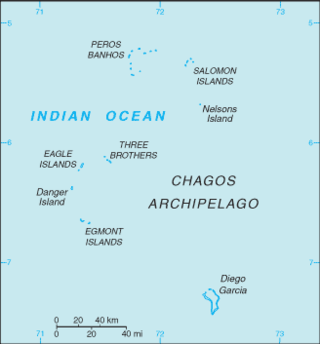
The British Indian Ocean Territory (BIOT) is an archipelago of 55 islands in the Indian Ocean, located south of India. It is situated approximately halfway between Africa and Indonesia. The islands form a semicircular group with an open sea towards the east. The largest, Diego Garcia, is located at the southern extreme end. It measures 60 square kilometres (23 sq mi) and accounts for almost three-quarters of the total land area of the territory. Diego Garcia is the only inhabited island and is home to the joint UK-US naval support facility. Other islands within the archipelago include Danger Island, Three Brothers Islands, Nelson Island, and Peros Banhos, as well as the island groups of the Egmont Islands, Eagle Islands, and the Salomon Islands.

The Swan Islands is a chain of three islands located in the northwestern Caribbean Sea, approximately 153 km (95 mi) northeast of the eastern coast of Honduras, with a combined land area of 3.1 km2 (1.2 sq mi).
Rose Atoll, sometimes called Rose Island or Motu O Manu by people of the Manu'a Islands, is an oceanic atoll within the U.S. territory of American Samoa. An uninhabited wildlife refuge, it is the southernmost point belonging to the United States, about 170 miles to the east of Tutuila, the principal island of American Samoa. The land area is just 0.05 km2 at high tide. The total area of the atoll, including lagoon and reef flat amounts to 6.33 km2. Just west of the northernmost point is a channel into the lagoon, about 80 metres (260 ft) wide. There are two islets on the northeastern rim of the reef, larger Rose Island, 3.5 metres (11 ft) high, in the east and the non-vegetated Sand Island, 1.5 metres (5 ft) high, in the north.

Gaafaru is one of the inhabited islands of Kaafu Atoll, the only island of the natural atoll known as Gaafaru.

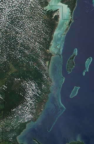
The Mesoamerican Barrier Reef System (MBRS), also popularly known as the Great Mayan Reef or Great Maya Reef, is a marine region that stretches over 1,126 kilometres (700 mi) along the coasts of four countries – Mexico, Belize, Guatemala, and Honduras – from Isla Contoy at the northern tip of the Yucatán Peninsula south to Belize, Guatemala and the Bay Islands of Honduras. It is the second-longest reef system in the world.
Rosalind Bank, also called Rosalinda or Rosa Linda Bank, is a large, completely submerged bank or atoll in the western Caribbean Sea. It is the culmination of an area of coral reef, some 300 kilometres (190 mi) long, that extends eastward from Cabo Gracias a Dios. The bank area is part of an extensive structure, known as Nicaragua Rise, that continues further east through Pedro Bank towards Jamaica.

Saba Bank in the Caribbean Netherlands is the largest submarine atoll in the Atlantic Ocean and has some of the richest diversity of marine life in the Caribbean Sea. In 2010, it was designated as Saba Bank National Park, one of the national parks of the Netherlands, and was officially recognized as such in 2012.

Scott and Seringapatam Reefs is a group of atoll-like reefs in the Timor Sea more than 300 kilometres (190 mi) northwest of Cape Leveque, Western Australia, on the edge of the continental shelf. There are three or four separate reef structures, depending on whether Scott Reef Central is counted separately.
The Belize Barrier Reef is a series of coral reefs straddling the coast of Belize, roughly 300 metres (980 ft) offshore in the north and 40 kilometres (25 mi) in the south within the country limits. The Belize Barrier Reef is a 300-kilometre (190 mi) long section of the 900-kilometre (560 mi) Mesoamerican Barrier Reef System, which is continuous from Cancún on the north-eastern tip of the Yucatán Peninsula through the Riviera Maya and down to Honduras, making it the second largest coral reef system in the world after the Great Barrier Reef in Australia. It is Belize's top tourist destination, popular for scuba diving and snorkeling and attracting almost half of its 260,000 visitors. It is also vital to the country's fishing industry.

Cay Sal Bank is the third largest and the westernmost of the Bahama Banks. It is located between 23º27'N - 24º10'N and 079º25'W – 080º35'W. In a geographical sense, it is separate from the Bahamas proper as it is much closer to Cuba than to the closest Bahamian island. It is separated by Santaren Channel from the Great Bahama Bank, the western rim of which is 50 km (31 mi) to the east. The Straits of Florida separate it from the United States mainland and the Florida Keys.
Rosario Bank is a submerged former atoll in the southern Caribbean Sea, located less than 20 km south of Misteriosa Bank. It lies within Honduras's exclusive economic zone.

The habitat of deep-water corals, also known as cold-water corals, extends to deeper, darker parts of the oceans than tropical corals, ranging from near the surface to the abyss, beyond 2,000 metres (6,600 ft) where water temperatures may be as cold as 4 °C (39 °F). Deep-water corals belong to the Phylum Cnidaria and are most often stony corals, but also include black and thorny corals and soft corals including the Gorgonians. Like tropical corals, they provide habitat to other species, but deep-water corals do not require zooxanthellae to survive.

The Structure and Distribution of Coral Reefs, Being the first part of the geology of the voyage of the Beagle, under the command of Capt. Fitzroy, R.N. during the years 1832 to 1836, was published in 1842 as Charles Darwin's first monograph, and set out his theory of the formation of coral reefs and atolls. He conceived of the idea during the voyage of the Beagle while still in South America, before he had seen a coral island, and wrote it out as HMS Beagle crossed the Pacific Ocean, completing his draft by November 1835. At the time there was great scientific interest in the way that coral reefs formed, and Captain Robert FitzRoy's orders from the Admiralty included the investigation of an atoll as an important scientific aim of the voyage. FitzRoy chose to survey the Keeling Islands in the Indian Ocean. The results supported Darwin's theory that the various types of coral reefs and atolls could be explained by uplift and subsidence of vast areas of the Earth's crust under the oceans.

Placer is a term used by Portuguese and Spanish navigators and cartographers to refer to a certain kind of submerged bank or reef. Commonly the bottom of such a reef is sandy, but there are some where the bottom is muddy or stoney. Although most reefs designated as placer are flat and shallow, exceptionally there are some that do not share those characteristics and are known as placer acantilado. A placer usually provides an anchorage for seagoing vessels.

Recreational dive sites are specific places that recreational scuba divers go to enjoy the underwater environment or for training purposes. They include technical diving sites beyond the range generally accepted for recreational diving. In this context all diving done for recreational purposes is included. Professional diving tends to be done where the job is, and with the exception of diver training and leading groups of recreational divers, does not generally occur at specific sites chosen for their easy access, pleasant conditions or interesting features.
