

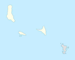
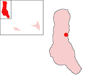
Mitsamiouli (population 6,100) is a town on the northwest coast of Grande Comore in the Comoros.
Mitsamiouli (population 6,100) is a town on the northwest coast of Grande Comore in the Comoros.
On 23 November 1996, Ethiopian Airlines Flight 961 made a crash-landing in the shallow waters 500 meters (1,600 ft) offshore from Le Galawa Beach Hotel in Mitsamiouli. Of the 175 passengers, 125 died, despite rescue attempts by island residents and tourists. [1]
Mitsamiouli lies on the northwest coast of the island, along the main coast road RN-1 and RN-3. This coastal road connects it to Djomani and Ntsaouéni further to the south on the west coast and Ivoini on the northeast coast. The RR 122 road runs south from Mitsamiouli and leads to the village of Bangoi Mafsankoa further inland, which has its own mosque. [2] Lac Sale Crater – Lac Sale is an ancient volcano crater, near Mitsamihuli, filled with sea water.
Tourism is important in the area, particularly from European honeymooners. [3] Fishing is also practiced in Mitsamihuli. [4]

Victoria Island is a large island in the Arctic Archipelago that straddles the boundary between Nunavut and the Northwest Territories of Canada. It is the eighth largest island in the world, and at 217,291 km2 (83,897 sq mi) in area, it is Canada's second largest island. It is nearly double the size of Newfoundland (111,390 km2 [43,008 sq mi]), and is slightly larger than the island of Great Britain (209,331 km2 [80,823 sq mi]) but smaller than Honshu (225,800 km2 [87,182 sq mi]). It contains the world's largest island within an island within an island. The western third of the island lies in the Inuvik Region of the Northwest Territories; the remainder is part of Nunavut's Kitikmeot Region.
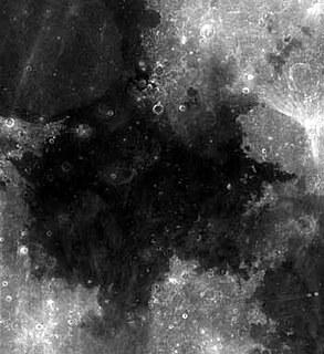
Mare Tranquillitatis is a lunar mare that sits within the Tranquillitatis basin on the Moon. The mare material within the basin consists of basalt formed in the intermediate to young age group of the Upper Imbrian epoch. The surrounding mountains are thought to be of the Lower Imbrian epoch, but the actual basin is probably Pre-Nectarian. The basin has irregular margins and lacks a defined multiple-ringed structure. The irregular topography in and near this basin results from the intersection of the Tranquillitatis, Nectaris, Crisium, Fecunditatis, and Serenitatis basins with two throughgoing rings of the Procellarum basin. Palus Somni, on the northeastern rim of the mare, is filled with the basalt that spilled over from Tranquillitatis.
The New Zealand state highway network is the major national highway network in New Zealand. Nearly 100 roads in the North and South Islands are state highways. All state highways are administered by the NZ Transport Agency.

Ethiopian Airlines Flight 961 was a scheduled flight serving the route Addis Ababa–Nairobi–Brazzaville–Lagos–Abidjan. On 23 November 1996, the aircraft serving the flight, a Boeing 767-200ER, was hijacked en route from Addis Ababa to Nairobi by three Ethiopians seeking asylum in Australia. The plane crash-landed in the Indian Ocean near Grande Comore, Comoros Islands due to fuel exhaustion; 125 of the 175 passengers and crew on board, including the three hijackers, died. The crash was captured on video.

The A27 is a major road in England. It runs from its junction with the A36 at Whiteparish in the county of Wiltshire. It closely parallels the south coast in Hampshire, then passes through West Sussex and terminates at Pevensey in East Sussex.

A pole of inaccessibility with respect to a geographical criterion of inaccessibility marks a location that is the most challenging to reach according to that criterion. Often it refers to the most distant point from the coastline, implying a maximum degree of continentality or oceanity. In these cases, pole of inaccessibility can be defined as the center of the largest circle that can be drawn within an area of interest without encountering a coast. Where a coast is imprecisely defined, the pole will be similarly imprecise.

The Canada–United States border, officially known as the International Boundary, is the longest international border in the world between two countries. The terrestrial boundary is 8,891 kilometers (5,525 mi) long. The land border has two sections: Canada's border with the contiguous U.S. to its south, and Canada's border with the U.S. state of Alaska to its west. The bi-national International Boundary Commission deals with matters relating to marking and maintaining the boundary, and the International Joint Commission deals with issues concerning boundary waters. The agencies currently responsible for facilitating legal passage through the international boundary are the Canada Border Services Agency (CBSA) and U.S. Customs and Border Protection (CBP).
This is a list of extreme points on Earth, the geographical locations that are farther north or south than, higher or lower in elevation than, or farthest inland or out to sea from, any other locations on the landmasses, continents or countries.
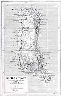
Grande Comore is an island in the Indian Ocean off the coast of Africa. It is the largest island in the Comoros nation. Most of its population is of the Comorian ethnic group. Its population as of 2006 is about 316,600. The island's capital is Moroni, which is also the national capital. The island is made up of two shield volcanoes, with Mount Karthala being the country's highest point at 2,361 m (7,746 ft) above sea level. According to the 2009 revision of the constitution of 2002, it is governed by an elected Governor, as are the other islands, with the federal government being much reduced in power. The name Ngazidja is sometimes seen in the now nonstandard form Njazidja.

Alberta Provincial Highway No. 2, commonly referred to as Highway 2 or the Queen Elizabeth II Highway, is a major highway in Alberta that stretches from the Canada–United States border through Calgary and Edmonton to Grande Prairie. Running primarily north to south for approximately 1,273 kilometres (791 mi), it is the longest and busiest highway in the province carrying more than 170,000 vehicles per day near Downtown Calgary. The Fort Macleod—Edmonton section forms a portion of the CANAMEX Corridor that links Alaska to Mexico. More than half of Alberta's 4 million residents live in the Calgary–Edmonton Corridor created by Highway 2.
Chezani is a town on the island of Grande Comore in the Comoros. It is the chief town of the region of Mboinkou. On 1996, August, after a football match between Hantsindzi and Chezani, 4 persons from Hantsindzi were killed. These tragic events had led to the exclusion of Chezani population from all Ngazidja places and to the execution of Said Mohamed Fadhul (Robin), the leader of the massacre. Some years later, on April 21, 2001, 4 persons from Chezani were killed by an organized band from Hantsindzi as a revenge of the 96's events.
Itsinkoudi is a town located on the island of Grande Comore in the Comoros.
National Route 58 is a Japanese national highway connecting the capital cities Kagoshima and Naha of Kagoshima Prefecture and Okinawa Prefecture, respectively. With a total length of 884.4 kilometers (549.5 mi), it is the longest national highway in Japan, though it measures only 245.3 kilometers (152.4 mi) on land. The highway begins at an intersection with National Routes 3 and 10 in Kagoshima. From Kagoshima, it travels southwest along the first island chain that divides the Pacific Ocean from the East China Sea. From the north to the south, it has sections on the islands of Tanegashima, Amami Ōshima, and finally, Okinawa. On Okinawa it ends at an intersection with National Routes 330, 331, and 390 in Naha.

Stony Rapids is a northern hamlet in Northern Saskatchewan, Canada. It is located 82 kilometres (51 mi) south of the border to the Northwest Territories, the community is astride the Fond du Lac River. This river connects the community to Fond-du-Lac, Uranium City and Camsell Portage.

Bahia Bakari is a French woman who was the sole survivor of Yemenia Flight 626, an Airbus A310, which crashed into the Indian Ocean near the north coast of Grande Comore, Comoros on 30 June 2009, killing the 152 other people on board. Bakari, who could barely swim and had no life vest, clung to a piece of aircraft wreckage, floating in heavy seas for over nine hours, much of it in pitch darkness, before being rescued. Her mother, who had been traveling with her from Paris, France, for a summer vacation in Comoros, died in the crash.
La Grille is a volcano in the Comoros archipelago on the island of Grande Comore.
Mount Gurage is a mountain located in central Ethiopia. It is the highest point in both the Gurage Zone and the entire Southern Nations, Nationalities, and Peoples' Region. The mountain has a latitude and longitude of 8°17′N38°23′E and an elevation of 3719 meters above sea level. To the north is the village of Anige, while to the east is Bu'i.
Ivoini is a village on the island of Grande Comore (Ngazidja) in the Comoros. According to the 1991 census, the village had a population of 991.
The rivière aux Rats is a tributary of the Gulf of Saint Lawrence, flowing in the municipality of L'Île-d'Anticosti, in the Minganie Regional County Municipality, in the administrative region of Côte-Nord, in province of Quebec, in Canada.

Solitary Islands Way is a road in the Mid North Coast region of New South Wales, located north of the city of Coffs Harbour. It links the towns of Woolgoolga and Corindi Beach to the Pacific Highway. It consists of a mix of newly constructed roads, pre-existing Council-owned roads and former sections of the highway that were bypassed by new alignments in 2013 and 2017.
Coordinates: 11°23′S43°17′E / 11.383°S 43.283°E
| | This Comoros location article is a stub. You can help Wikipedia by expanding it. |