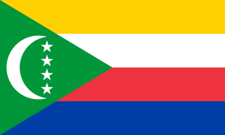
The Comoros, officially the Union of the Comoros, is an island country in the Indian Ocean, at the northern end of the Mozambique Channel off the eastern coast of Africa. It shares maritime borders with Madagascar and Mayotte to the southeast, Tanzania to the northwest, Mozambique to the west, and the Seychelles to the northeast. Its capital and largest city is Moroni. The religion of the majority of the population, and the official state religion, is Sunni Islam. As a member of the Arab League, it is the only country in the Arab world which is entirely in the Southern Hemisphere. It is also a member state of the African Union, the Organisation internationale de la Francophonie, the Organisation of Islamic Cooperation, and the Indian Ocean Commission. The country has three official languages: Comorian, French and Arabic.
The Comorians inhabiting Grande Comore, Anjouan, and Mohéli share African-Arab origins. Islam is the dominant religion, and Quranic schools for children reinforce its influence. Although Islamic culture is firmly established throughout, a small minority are Christian.

Gjakova or Đakovica is the seventh most populous city of Kosovo and the capital of the eponymous municipality and district. The city has 40,827 inhabitants, while the municipality has 94,556 inhabitants.

Moroni is the largest city, federal capital, and seat of the government of the Union of the Comoros, a sovereign archipelago nation in the Indian Ocean. Moroni means "at the river". Moroni is the capital of the semi-autonomous island of Ngazidja, the largest of the three main islands of the republic. The city's estimated population in 2003 was 41,557 residents. Moroni, which lies along the Route Nationale 1, has a port and several mosques such as the Badjanani Mosque.
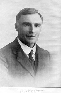
Muhammad Marmaduke Pickthall was an English Islamic scholar noted for his 1930 English translation of the Quran, called The Meaning of the Glorious Koran. His translation of the Qur'an is one of the most widely known and used in the English-speaking world. A convert from Christianity, Pickthall was a novelist, esteemed by D. H. Lawrence, H. G. Wells, and E. M. Forster, as well as a journalist, headmaster, and political and religious leader. He declared his conversion to Islam in dramatic fashion after delivering a talk on 'Islam and Progress' on 29 November 1917, to the Muslim Literary Society in Notting Hill, West London.

Ilorin is the state capital of Kwara State in Western Nigeria. As of the 2006 census, it had a population of 777,667, making it the 7th largest city by population in Nigeria.

Algester is a southern suburb in the City of Brisbane, Queensland, Australia. In the 2016 census Algester had a population of 8,433 people.
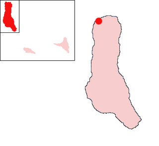
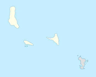
Mitsamiouli is a town on the northwest coast of Grande Comore in the Comoros.
Domoni is the second largest city on the Comorian island of Anjouan in the Indian Ocean and is located on the east coast of the island. It was the capital of the island in the past while the present capital of Anjouan is Mutsamudu.
Chezani is a town on the island of Grande Comore in the Comoros. It is the chief town of the region of Mboinkou. On 1996, August, after a football match between Hantsindzi and Chezani, 4 persons from Hantsindzi were killed. These tragic events had led to the exclusion of Chezani population from all Ngazidja places and to the execution of Said Mohamed Fadhul (Robin), the leader of the massacre. Some years later, on April 21, 2001, 4 persons from Chezani were killed by an organized band from Hantsindzi as a revenge of the 96's events.

Islam in Hungary has a long history that dates back to at least the 10th century. The influence of Sunni Islam was especially pronounced in the 16th century during the Ottoman period in Hungary. As of 2020, the Muslim population in Hungary is approximately 5,000.

Senbag is an upazila of Noakhali District. Senbag is located within an area of 155.83 square kilometres (60.2 sq mi), which is enclosed by Nangalkot upazila, Noakhali Sadar and Companiganj upazilas (south), Daganbhuyiyan upazila, Feni (east), with Begumganj and Laksam upazilas.
Sherpur Upazila is an upazila of Bogra District in the Division of Rajshahi, Bangladesh. Sherpur Thana was established in 1962 and was converted into an upazila in 1983. It is named after its administrative center, the town of Sherpur. It is said that there once lived Sher family in the vicinity, from which the name "Sherpur" evolved.
Eklera is a small Muslim farming village located in the district of Surat, Gujarat, India. It is about 15 kilometres (9.3 mi) from the Arabian Sea coast and less than 4 kilometres (2.5 mi) from Surat City Municipal Boundary. Its nearest railhead is Bhestan in Surat. Eklera has a population of about 1200 people, the vast majority being Sunni Surti Vohra and a small number of Tribal Hindus. Approximately a quarter of the population are settled abroad including UK mainly London, Dewsbury, Batley, Botswana, Panama, South Africa, Canada, New Zealand. Most of the families are engaged in agriculture. The smaller adjacent village of Bhanodra is often counted within Eklera.
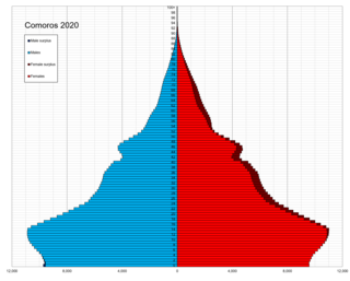
Health in the Comoros continues to face public health problems characteristic of developing countries. After Comoros's independence in 1975, the French withdrew their medical teams, leaving the three islands' already rudimentary health care system in a state of severe crisis. French assistance was eventually resumed, and other nations also contributed medical assistance to the young republic.
The Shirazi people, also known as Mbwera, are an ethnic group inhabiting the Swahili coast and the nearby Indian ocean islands. They are particularly concentrated on the islands of Zanzibar, Pemba and Comoros.
Hantsindzi is a village on the island of Grande Comore (Ngazidja) in the Comoros. According to the 1991 census, the village had a population of 1508.
Koki is a village on the island of Anjouan in the Comoros. According to the 1991 census the village had a population of 3,066. The current calculation for 2012 is 5,866 people
Patsy is a village on the island of Anjouan in the Comoros. According to the 1991 census, the village had a population of 932.

Taht-el-kale is a neighbourhood, quarter of Nicosia, Cyprus and the mosque situated therein.