The Comoros, officially the Union of the Comoros, is an archipelagic country made up of three islands in Southeastern Africa, located at the northern end of the Mozambique Channel in the Indian Ocean. Its capital and largest city is Moroni. The religion of the majority of the population, and the official state religion, is Sunni Islam. Comoros proclaimed its independence from France on 6 July 1975. The Comoros is the only country of the Arab League which is entirely in the Southern Hemisphere. It is a member state of the African Union, the Organisation internationale de la Francophonie, the Organisation of Islamic Co-operation, and the Indian Ocean Commission. The country has three official languages: Shikomori, French and Arabic.
The history of the Comoros extends back to about 800–1000 AD when the archipelago was first inhabited. The Comoros have been inhabited by various groups and sultanates throughout this time. France colonised the islands in the 19th century, and they became independent in 1975.

The Comoros archipelago consists of four main islands aligned along a northwest–southeast axis at the north end of the Mozambique Channel, between Mozambique and the island of Madagascar. Still widely known by their French names, the islands officially have been called by their Swahili names by the Comorian government. They are Grande Comore (Njazidja), Mohéli (Mwali), Anjouan (Nzwani), and Mayotte (Mahoré). The islands' distance from each other—Grande Comore is some 200 kilometers from Mayotte, forty kilometers from Mohéli, and eighty kilometers from Anjouan—along with a lack of good harbor facilities, make transportation and communication difficult. Comoros are sunny islands.
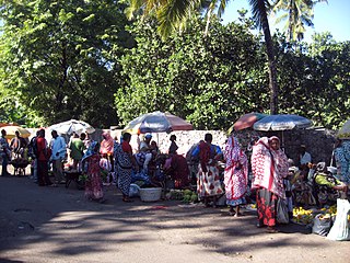
The Comorians inhabiting Grande Comore, Anjouan, and Mohéli share African-Arab origins. Islam is the dominant religion, and Quranic schools for children reinforce its influence. Although Islamic culture is firmly established throughout, a small minority are Christian.
There are a number of systems of transport in the Comoros. The Comoros possesses 880 km (547 mi) of road, of which 673 km (418 mi) are paved. It has three seaports: Fomboni, Moroni and Moutsamoudou, but does not have a merchant marine, and no longer has any railway network. It has four airports, all with paved runways, one with runways over 2,438 m (7,999 ft) long, with the others having runways shorter than 1,523 m (4,997 ft).
Mayotte, officially the Department of Mayotte, is an overseas department and region and single territorial collectivity of France. It is located in the northern part of the Mozambique Channel in the Indian Ocean off the coast of Southeastern Africa, between Northwestern Madagascar and Northeastern Mozambique. Mayotte consists of a main island, Grande-Terre, a smaller island, Petite-Terre, as well as several islets around these two. Mayotte is the most prosperous territory in the Mozambique Channel, making it a major destination for immigration.
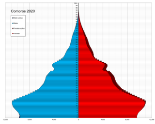
The economy of the Comoros is based on subsistence agriculture and fishing. Comoros has inadequate transportation links, a young and rapidly increasing population, and few natural resources. The low educational level of the labor force contributes to a subsistence level of economic activity, high unemployment, and a heavy dependence on foreign grants and technical assistance. The Comoros, with an estimated gross domestic product (GDP) per capita income of about $700, is among the world's poorest and least developed nations. Although the quality of the land differs from island to island, most of the widespread lava-encrusted soil formations are unsuited to agriculture. As a result, most of the inhabitants make their living from subsistence agriculture and fishing. Average wages in 2007 hover around $3–4 per day.

Anjouan is an autonomous volcanic island in the Comoro Islands in the southwestern Indian Ocean, part of the Union of the Comoros. It is known in Shikomori as Ndzuani, Ndzuwani or Nzwani, and, until the early twentieth century when the name fell out of general use, in English as Johanna. Historically it was also called Hinzuan or Hanzoan.

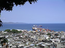
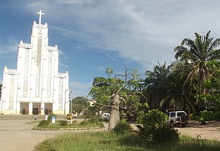
Moroni is the largest city, federal capital, and seat of the government of the Union of the Comoros, a sovereign archipelago nation in the Indian Ocean. Moroni means "at the river". Moroni is the capital of the semi-autonomous island of Ngazidja, the largest of the three main islands of the republic. The city's estimated population in 2003 was 41,557 residents. Moroni, which lies along the Route Nationale 1, has a port and several mosques such as the Badjanani Mosque.
Mahajanga is a city and an administrative district on the northwest coast of Madagascar. The city of Mahajanga is the capital of the Boeny Region. The district had a population of 258,068 in 2020.

The Comoro Islands are a group of volcanic islands in the Mozambique Channel, an arm of the Indian Ocean lying between Madagascar and the African mainland. Three of the islands form the Union of the Comoros, a sovereign nation, while Mayotte belongs to France.
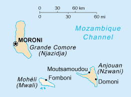
Mohéli, also known as Mwali, is an autonomously-governed island that forms part of the Union of the Comoros. It is the smallest of the three major islands in the country. It is located in the Indian Ocean off the coast of Africa and it is the smallest of the four major Comoro Islands. Its capital and largest city is Fomboni.

Nosy Be is an island off the northwest coast of Madagascar. Nosy Be is Madagascar's largest and busiest tourist destination. It has an area of 320.02 km2 (123.56 sq mi), and its population was 109,465 according to the provisional results of the 2018 Census.
Domoni is the second largest city on the Comorian island of Anjouan in the Indian Ocean and is located on the east coast of the island. It was the capital of the island in the past while the present capital of Anjouan is Mutsamudu.

Vohemar is a coastal city and a municipality in northern Madagascar. It belongs to the district of Iharana, which is a part of Sava Region. It had a population of 22047 in 2018.

The Malagasy brush warbler, also known as the Madagascar brush warbler, is a species of Old World warbler in the family Acrocephalidae.. The Malagasy brush warbler is a widespread species of forest undergrowth and is found primarily in both Madagascar and the Comoro Islands. The bird is typically found alone or in pairs of 2 and flies short distances due to a small wingspan. Its natural habitats are subtropical or tropical dry forests, subtropical or tropical moist lowland forests, and subtropical or tropical moist shrubland.
Health in the Comoros continues to face public health problems characteristic of developing countries. After Comoros's independence in 1975, the French withdrew their medical teams, leaving the three islands' already rudimentary health care system in a state of severe crisis. French assistance was eventually resumed, and other nations also contributed medical assistance to the young republic.

The invasion of Anjouan, on March 25, 2008, was an amphibious assault led by the Comoros, backed by African Union (AU) forces, including troops from Sudan, Tanzania, Senegal, along with logistical support from Libya and France. The objective of the invasion was to topple Colonel Mohamed Bacar's leadership in Anjouan, an island in the Union of Comoros, when he refused to step down after a disputed 2007 election, in defiance of the federal government and the AU. The Comoros archipelago in the Indian Ocean has had a fractious history since its independence from France in 1975, experiencing more than 20 coups or attempted coups.
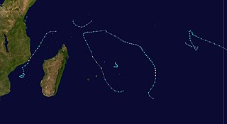
The 1982–83 South-West Indian Ocean cyclone season was the least active cyclone season in the basin since 1961–1962. There were six systems that were named, although three of them – Arilisy, Clera, and Fely – failed to intensify beyond tropical depression status. No storms reached tropical cyclone status, according to the official warning agency for the basin, Météo-France, although the two strongest storms – Bemany and Elinah – peaked just below that intensity. The first named storm, Arilisy, formed on October 27, and dissipated without having affected land. However, the Joint Typhoon Warning Center (JTWC), which is an unofficial warning center for the basin, briefly tracked a tropical depression in July. The next storm was Bemany, which passed east of Mauritius near peak intensity in early December. Tropical Depression Clera existed briefly in the middle of September, and Tropical Storm Dadafy moved across the eastern portion of the basin in late December.

The official languages of the Comoros are Comorian, French and Arabic, as recognized under its 2001 constitution. Although each language holds equal recognition under the constitution, language use varies across Comorian society. Unofficial minority languages such as Malagasy and Swahili are also present on the island with limited usage. According to Harriet Joseph Ottenheimer, a professor of anthropology at Kansas State university, the linguistic diversity of the Comoros is the result of its rich history as part of the Indian maritime trade routes and its periods of Malagasy and French colonial rule.