Related Research Articles
The Petermann Ranges are a number of associated mountain ranges including the Östliche Petermann, Mittlere Petermann, Westliche Petermann, Südliche Petermann, and Pieck Ranges, located just east of the Humboldt Mountains in the central Wohlthat Mountains of Queen Maud Land.
Isdalsegga Ridge is a rock ridge surmounted by Pinegin Peak, forming the east wall of Isdalen Valley in the Südliche Petermann Range of the Wohlthat Mountains, Antarctica. It was discovered and plotted from air photos by the Third German Antarctic Expedition, 1938–39. It was replotted from air photos and surveys by the Sixth Norwegian Antarctic Expedition, 1956–60, and named "Isdalsegga" in association with Isdalen Valley.
Austbanen Moraine is a medial moraine in the glacier between the Westliche Petermann Range and the Mittlere Petermann Range in the Wohlthat Mountains, originating at Svarttindane Peaks and trending north for 12 miles (19 km). It was first roughly plotted from air photos by the Third German Antarctic Expedition between 1938 and 1939. It was mapped by the Sixth Norwegian Antarctic Expedition from 1956 to 1960, from air photos and from surveys, and named "Austbanen". Vestbanen Moraine, a similar paralleling feature, lies 7 miles (11 km) westward.
Gneiskopf Peak is a peak 2,930 metres (9,600 ft) high rising 8 kilometres (5 mi) southwest of Mount Neustruyev at the southern end of the Südliche Petermann Range, in the Wohlthat Mountains of Queen Maud Land, Antarctica. It was discovered and given the descriptive name Gneiskopf by the Third German Antarctic Expedition (1938–1939), led by Captain Alfred Ritscher.
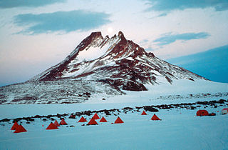
Mount Neustruyev is a peak in East Antarctica, 2,900 m, standing 5 mi NNE of Gneiskopf Peak in Südliche Petermann Range, Wohlthat Mountains, Queen Maud Land.
The Östliche Petermann Range is one of the Petermann Ranges, trending in a north–south direction for 15 nautical miles (28 km) from Per Spur to the Gornyye Inzhenery Rocks, in the Wohlthat Mountains of Queen Maud Land. It was discovered and plotted from air photos by German Antarctic Expedition of 1938–39, and so named by them for its eastern location in the Petermann Ranges.
Svarthorna Peaks is a series of five or more peaks on the curving ridge that forms the south end of Mittlere Petermann Range, in the Wohlthat Mountains of Queen Maud Land. Discovered by the German Antarctic Expedition under Ritscher, 1938–39, who gave the descriptive name "Schwarze Horner". The peaks were remapped by the Norwegian Antarctic Expedition, 1956–60, who used the spelling Svarthorna. The Norwegian spelling has been recommended by Advisory Committee on Antarctic Names (US-ACAN) to agree with associated features in the area having this name.
Svarthornbotnen Cirque is a large cirque just northeast of Store Svarthorn Peak in the Mittlere Petermann Range, Wohlthat Mountains in Antarctica. Discovered and plotted from air photos by German Antarctic Expedition, 1938–39. Replotted by Norwegian Antarctic Expedition, 1956–60, and named Svarthornbotnen.
Svarthornkammen Ridge is a high rock ridge extending north for 5 nautical miles (9 km) from Svarthorna Peaks in the Mittlere Petermann Range, Wohlthat Mountains. Discovered and plotted from air photos by German Antarctic Expedition, 1938–39. Replotted from air photos and surveys by Norwegian Antarctic Expedition, 1956–60, and named Svarthornkammen.
Svarttindane Peaks is a cluster of sharp peaks including Veselaya Mountain, located 2 nautical miles (3.7 km) south of Store Svarthorn Peak in Sudliche Petermann Range, Wohlthat Mountains. Discovered and plotted from air photos by German Antarctic Expedition, 1938–39. Replotted from air photos and surveys by Norwegian Antarctic Expedition, 1956–60, and named Svarttindane.
Daykovaya Peak is a prominent peak, 1,995 metres (6,550 ft) high, rising between Mount Hansen and Kare Bench in the Westliche Petermann Range, Wohlthat Mountains. It was discovered and plotted from air photos by the Third German Antarctic Expedition, 1938–39. It was mapped from air photos and surveys by the Sixth Norwegian Antarctic Expedition, 1956–60; remapped by the Soviet Antarctic Expedition, 1960–61, and named Gora Daykovaya.
The Johnson Peaks are a cluster of detached peaks which mark the northern extremity of the Mittlere Petermann Range, in the Wohlthat Mountains of Queen Maud Land, Antarctica. They were discovered and plotted from air photos by the Third German Antarctic Expedition, 1938–39, were replotted from air photos and surveys by the Sixth Norwegian Antarctic Expedition, 1956–60, and were named for Rolf Johnson, a steward with the Norwegian expedition, 1958–59.
Krasheninnikov Peak is a peak, 2,525 metres (8,280 ft) high, on the south side of the Svarthausane Crags in the Südliche Petermann Range of the Wohlthat Mountains, Antarctica. It was discovered and plotted from air photos by the Third German Antarctic Expedition, 1938–39, and was mapped from air photos and surveys by the Sixth Norwegian Antarctic Expedition, 1956–60. It was remapped by the Soviet Antarctic Expedition, 1960–61, and named after Russian geographer S.P. Krasheninnikov.
Krakken Mountain is a mountain 1 nautical mile (2 km) north of Sandseten Mountain and just northwest of Gneysovaya Peak in the Westliche Petermann Range of the Wohlthat Mountains, Antarctica. It was discovered and plotted from air photos by the Third German Antarctic Expedition, 1938–39, was replotted from air photos and surveys by the Sixth Norwegian Antarctic Expedition, 1956–60, and named Krakken.
Store Svarthorn Peak is a very prominent black peak rising abruptly at the southwest extremity of Mittlere Petermann Range, in the Wohlthat Mountains of Queen Maud Land. It was discovered and given the descriptive name "Grosses Schwarz-Horn" by the German Antarctic Expedition under Ritscher, 1938–39. The peak was remapped by the Norwegian Antarctic Expedition, 1956–60, who used the form Store Svarthorn. The Norwegian spelling has been recommended by Advisory Committee on Antarctic Names (US-ACAN) to agree with associated features in the area having this name.
Storsåtklubben Ridge is a ridge, 3 nautical miles (5.6 km) long, located 5 nautical miles (9.3 km) northeast of Mount Hansen in the Mittlere Petermann Range, in the Wohlthat Mountains of Queen Maud Land. It was discovered and plotted from air photos by the German Antarctic Expedition of 1938-39 and replotted from air photos and surveys by the Norwegian Antarctic Expedition in 1956–60, and named Storsåtklubben.
Gneysovaya Peak is a peak, 2,050 metres (6,730 ft) high, on the ridge connecting Krakken Mountain and Sandseten Mountain in the Westliche Petermann Range, Wohlthat Mountains, Antarctica. It was discovered and plotted from air photos by the Third German Antarctic Expedition, 1938–39. It was mapped from air photos and surveys by the Sixth Norwegian Antarctic Expedition, 1956–60, remapped by the Soviet Antarctic Expedition, 1960–61, and named "Gora Gneysovaya".
Gråkammen Ridge is a mountainous ridge that includes Tambovskaya Peak and Mount Solov'yev, rising between the Gråhorna Peaks and Aurdalen Valley in the Westliche Petermann Range of the Wohlthat Mountains in Antarctica. It was discovered and plotted from air photos by the Third German Antarctic Expedition, 1938–39. It was replotted from air photos and surveys by the Sixth Norwegian Antarctic Expedition, 1956–60, and named Gråkammen.
Mount Hansen is a mountain, 1,895 metres (6,220 ft) high, standing 1 nautical mile (2 km) north of Kare Bench and just northwest of Daykovaya Peak at the northern extremity of the Westliche Petermann Range, in the Wohlthat Mountains of Antarctica. It was discovered and plotted from air photos by the Third German Antarctic Expedition, 1938–39. It was replotted from air photos and surveys by the Sixth Norwegian Antarctic Expedition, 1956–60, and named for Kare Hansen, a meteorologist with the Norwegian expedition, 1958–59.
References
![]() This article incorporates public domain material from "Mittlere Petermann Range". Geographic Names Information System . United States Geological Survey.
This article incorporates public domain material from "Mittlere Petermann Range". Geographic Names Information System . United States Geological Survey.