This article is about the demographic features of the population of Bosnia and Herzegovina, including population density, ethnicity, education level, health of the populace, economic status, religious affiliations and other aspects of the population.
The Politics of Bosnia and Herzegovina takes place in a framework of a parliamentary representative democracy, whereby executive power is exercised by the Council of Ministers of Bosnia and Herzegovina. Legislative power is vested in both the Council of Ministers and the Parliamentary Assembly of Bosnia and Herzegovina. Members of the Parliamentary Assembly are chosen according to a proportional representation system.

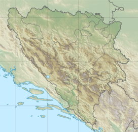
Republika Srpska is one of the two entities of Bosnia and Herzegovina, the other being the Federation of Bosnia and Herzegovina. It is located in the north and east of the country. Its largest city and administrative centre is Banja Luka, lying on the Vrbas river.

The Federation of Bosnia and Herzegovina is one of the two entities that compose the State of Bosnia and Herzegovina, the other being Republika Srpska. The Federation of Bosnia and Herzegovina consists of 10 autonomous cantons with their own governments and legislatures.

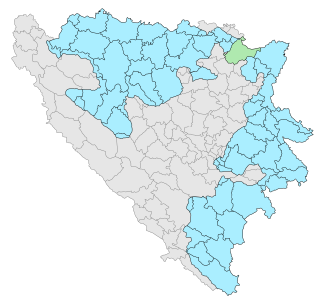
The Posavina Canton is one of ten cantons of the Federation of Bosnia and Herzegovina in Bosnia and Herzegovina. It is the smallest canton with an area of only 330.85 km2 (128 sq mi). The canton is an exclave of Federation of Bosnia and Herzegovina, being bordered by Republika Srpska and Brčko District to the south and the river Sava and Croatia to the north. Its capital is Orašje and the largest town is Odžak.
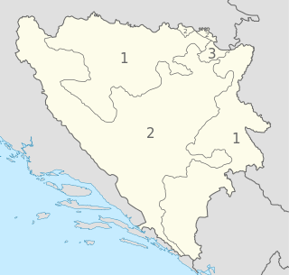
The political divisions of Bosnia and Herzegovina were created by the Dayton Agreement, which recognized a second tier of government in Bosnia and Herzegovina, comprising two entities: the Federation of Bosnia and Herzegovina (FBiH), with mostly Bosniaks and Croats, and the Republika Srpska (RS) with mostly Serbs – each governing roughly one half of the state's territory. The Federation of Bosnia and Herzegovina itself has a federal structure and consists of 10 autonomous cantons.
There is currently no official flag for the Federation of Bosnia and Herzegovina. The federation is part of the state of Bosnia and Herzegovina. The federation adopted its own flag in 1996, but the flag and associated coat of arms were deemed unconstitutional by the Constitutional Court of Bosnia and Herzegovina in 2007. The federation has not yet adopted a new flag, anthem or coat of arms; instead the symbols of the central state are used for official purposes as a provisional solution.

Teslić is a town and municipality located in Republika Srpska, an entity of Bosnia and Herzegovina. It is situated in the central part of the Republika Srpska, on the banks of Usora River. As of 2013, the town has a population of 7,518 inhabitants, while the municipality has 38,536 inhabitants.

The Republika Srpska was a self-proclaimed proto-state in Southeastern Europe under the control of the Army of Republika Srpska during the Bosnian War. It claimed to be a sovereign state, though this claim was not recognized by the Bosnian government, the United Nations, or any other recognized state. For the first few months of its existence, it was known as the Serbian Republic of Bosnia and Herzegovina.
Under the "Law on Territorial Organization and Local Self-Government" adopted in 1994, Republika Srpska was divided into 80 municipalities. After the conclusion of the Dayton Peace Agreement, the law was amended in 1996 to reflect the changes to the entity's borders and now provides for the division of Republika Srpska into 64 municipalities.

Istočno Sarajevo is a collective municipality in the Republika Srpska entity of Bosnia and Herzegovina. It consists of areas surrounding pre-war Sarajevo's that are now included in the Republika Srpska entity, and newly built areas. With an area of 1450 km2, Istočno Sarajevo is one of the largest administrative areas in the Balkans. As of 2013, it has a population of 61,516 inhabitants. Istočno Sarajevo is the largest city in Republika Srpska in terms of area, while it is in fifth place in terms of population. It is the only city of the entity that includes several municipalities: Istočna Ilidža, Istočno Novo Sarajevo, Pale, Istočni Stari Grad, Sokolac and Trnovo. It is separated from Sarajevo and Canton Sarajevo by the Inter-Entity Boundary Line (IEBL). The City Administration of East Sarajevo is located in the municipality of Istočno Novo Sarajevo, in Stefana Nemanje Street.

Kupres, also known as Kupres Republike Srpske is a municipality in western Republika Srpska, an entity of Bosnia and Herzegovina. It is bordering the region of Bosanska Krajina to the north. It is one of the most undeveloped and poorest municipalities in Bosnia and Herzegovina. The seat of the municipality is the village of Novo Selo.

Petrovo is a town and municipality located in Republika Srpska, an entity of Bosnia and Herzegovina. As of 2013, the town has a population of 2,322 inhabitants, while the municipality has 6,474 inhabitants.

General elections were held in Bosnia and Herzegovina on 1 October 2006. They decided the makeup of Bosnia and Herzegovina's Presidency as well as national, entity, and cantonal governments. Voter turnout was 53%.
The Bosnia and Herzegovina football league system is a series of connected leagues for football clubs in Bosnia and Herzegovina. The system is hierarchical, with promotion and relegation between leagues at different levels. The top division is organized by the Football Association of Bosnia and Herzegovina, the second and third levels by entity associations, and lower levels by cantonal or regional associations.
The Football Cup of Republika Srpska, also just known as the Republika Srpska Cup, is a secondary knockout football competition contested annually by clubs from the entity Republika Srpska, Bosnia and Herzegovina. The competition is run by the Football Association of Republika Srpska.
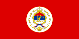
The Seal of Republika Srpska with the description: the flag of Republika Srpska and the Cyrillic letters "РС" ("RS"), the red-blue-white tricolor are in the center of the seal, twisted with the golden Oak leaves, a traditional pre-Christian symbol sacred to most Slavs. On the edge of the seal there is an inscription Republika Srpska. The open crown of Kotromanić is shown in the bottom of the seal and the seal itself is topped with a heraldic royal crown.
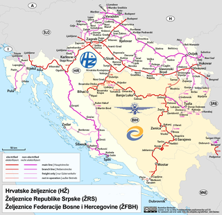
Railway operations in Bosnia and Herzegovina are successors of the Yugoslav Railways within the country boundaries following independence from Yugoslavia in March 1992.
The president of Republika Srpska is the highest executive authority in Republika Srpska, an entity in Bosnia and Herzegovina. It is one of the executive authorities, along with the Government of Republika Srpska. The president of Republika Srpska is directly elected for a term of four years, along with two vice presidents from different constituent nations. None of them can be from a same constituent nation at the same time. The president's residence is in Banja Luka.

Trebova Planina is a mountain in Zelengora mountain range in the Sutjeska National Park in the municipality of Foča, Republika Srpska, Bosnia and Herzegovina. It has an altitude of 1,872 metres (6,142 ft).