Tanzania is administratively divided into thirty-one regions.

Pwani Region is one of Tanzania's 31 administrative regions. The word "Pwani" in Swahili means the "coast". The regional capital is the town of Kibaha. The Region borders the Tanga Region to the north, Morogoro Region to the west, Lindi Region to the south, and surrounds Dar es Salaam Region to the east. The Indian Ocean also borders the region to its northeast and southeast. The region is home to Mafia Island, the Rufiji delta and Saadani National Park. The region is home to Bagamoyo town, a historical Swahili settlement, and the first colonial capital of German East Africa. According to the 2012 national census, the region had a population of 1,098,668, which was slightly lower than the pre-census projection of 1,110,917. From 2002 to 2012, the region's 2.2 percent average annual population growth rate was the seventeenth-highest in the country. It was also the 21st most densely populated region with 34 people per square kilometre., According to the 2022 census the population had nearly doubled to 2,024,947. the region is slightly larger than Belgium.

Rukwa Region(Mkoa wa Rukwa in Swahili) is one of Tanzania's 31 administrative regions The region covers a land area of 27,765 km2 (10,720 sq mi). The region is comparable in size to the combined land area of the nation state of Haiti. Rukwa Region is bordered to the north by Katavi Region, to the east by Songwe Region, to the south by the nation of Zambia and to the west by Lake Tanganyika, which forms a border between Tanzania and the Democratic Republic of the Congo. The regional capital is the municipality of Sumbawanga. According to the 2022 national census, the region had a population of 1,540,519.

Kigoma Region is one of Tanzania's 31 administrative regions. The regional capital is the city of Kigoma. Kigoma Region borders Kagera Region, Geita Region, Katavi Region, Tabora Region, DRC and Burundi According to the 2012 national census, the region had a population of 2,127,930, which was higher than the pre-census projection of 1,971,332. For 2002-2012, the region's 2.4 percent average annual population growth rate was tied for the fourteenth highest in the country. It was also the sixteenth most densely populated region with 57 people per square kilometer. With a size of 45,066 square kilometres (17,400 sq mi), the region is slightly smaller than Estonia.

Tabora Region is one of Tanzania's 31 administrative regions. The regional capital is the municipality of Tabora. The region is located in mid-western part of Tanzania. Tabora is bordered by Shinyanga to the north, Singida to the east, Mbeya and Songwe to the south. lastly, Katavi, Kigoma and Geita, border Tabora to the west. Tabora is by far the largest region in Tanzania by area. Most of the population in the region is concentrated in the north in Nzega district. According to the 2022 national census, Tabora Region had a population of 3,391,679.

Urambo is one of the seven districts of the Tabora Region of Tanzania. It is bordered to the north by the Kaliua District, to the east by the Uyui District, to the southeast by the Sikonge District, and to the southwest by the Katavi Region. Its administrative seat is the town of Urambo.

Sikonge District is one of the seven districts of the Tabora Region of Tanzania. The town of Sikonge is the administrative seat. The district has an area of 27,873 square kilometres (10,762 sq mi), but 26,834 square kilometres (10,361 sq mi) of it is in forest and game reserves. It is bordered to the northwest by Urambo District, to the north by Uyui District, to the east by Manyoni District of Singida Region, to the south by Chunya District of Mbeya Region, and to the southwest by Mlele District of Katavi Region.
Mpanda District is one of the five districts of the Katavi Region of Tanzania. Its administrative seat is the city of Mpanda. The district is bordered to the northwest by the Kigoma Region, to the northeast by the Tabora Region, to the east by the Mbeya Region, to the southeast by the Sumbawanga Urban District, to the southwest by the Nkasi District and to the west by Lake Tanganyika.

Nkasi District is one of the three districts of the Rukwa Region of Tanzania, with its headquarters in the village of Namanyere. It is bordered to the north by the Mpanda District of Katavi Region; to the east by the Sumbawanga District; to the south by the Sumbawanga Rural District and Zambia; and to the west by Lake Tanganyika across from the Democratic Republic of Congo.

The Angolan genet or miombo genet is a genet species endemic to Southern Africa. It is considered common in this region and therefore listed as Least Concern in the IUCN Red List. Little is known about its ecology.
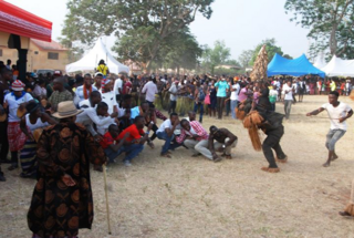
The Bende are a Bantu ethnic group based in the Mpanda District of the Katavi Region in western Tanzania. In 2009, the Bende population was estimated to number 41,290.

Uvinza is one of the eight administrative districts of Kigoma Region in Tanzania. Uvinza is bordered to the northwest by Kigoma District and Kigoma-Ujiji District. North of the district is bordered by Kasulu District. Lake Tanganyika borders the district on the west. Mpanda District in Katavi Region boders the district to the south and Kaliua District in Tabora Region borders the district to the east. The district is named in honor of the Vinza people whom the western part of district was their historic kingdom. Southern Uvinza District is home to the Mahale Mountains National Park. A unique park that is home to both Chimpanzees and lions in the same habitat.
Mpanda is a city in Katavi Region of Tanzania, East Africa with a postcode number 50100. It is the administrative centre of Katavi Region, Mpanda District and is itself one of the four districts of the region.

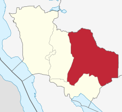
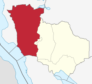
Katavi Region is one of Tanzania's 31 administrative regions. The region covers an area of 45,843 km2 (17,700 sq mi). The region is comparable in size to the combined land area of the nation state of Estonia. Katavi Region is bordered to the east by Tabora Region. The region is bordered to the south by Rukwa Region and Songwe Region. Lastly, Katavi borders DRC on Lake Tanganyika to the west. The region derives its name from Katavi, the spirit of lake Tanganyika. The regional capital city is Mpanda. According to the 2022 national census, the region had a population of 1,152,958.
Ugalla is a small town and ward in Mlele District of Katavi Region, Tanzania, East Africa. The town is on the left (west) bank of the Mtambo River just before it flows into the Ugalla River, on the edge of the Lujaba Swamp.

Kaliua District is one of the seven districts of the Tabora Region of Tanzania. It is bordered to the north by Kahama and Ushetu Districts, to the east by Uyui District and Urambo District, to the south by Katavi Region and to the west by Uvinza District and Geita Region. Its administrative seat is the town of Kaliua.
Katavi University of Agriculture is a public university. It is located in Katavi, Tanzania.

Songwe Region is one of Tanzania's 31 administrative regions. The region covers a land area of 27,656 km2 (10,678 sq mi). The region is comparable in size to the combined land area of the nation state of Haiti. Songwe Region borders the countries of Zambia and Malawi to the south: Tunduma is the main entry point into Zambia while Isongole is the main entry point into Malawi. Songwe also borders the Tanzanian regions of Rukwa and Katavi in the west, Tabora in the north, and Mbeya in the east. Lake Rukwa is a major body of water in the western part of the region. The region was created on 29 January 2016 from the western half of Mbeya Region. The regional capital is Vwawa. According to the 2022 national census, the region had a population of 1,344,687.
Mpimbwe District is a district council in the Katavi Region of Tanzania's Southern Highlands established in 2012. The district lies in the south of the region on Lake Rukwa.
Nsimbo District is a district council in the Katavi Region of Tanzania's Southern Highlands established in 2012. The district lies in the middle of the region east of the city of Mpanda. It is a tropical environment of mostly forest reserves and agricultural economy.