Nsimbo District

Last updated

Nsimbo
Katavi sunset.jpg
Nsimbo District in Katavi 2022.svg
Nsimbo District location in the Katavi Region
Coordinates: 6°22′22″S31°11′02″E / 6.3727°S 31.184°E / -6.3727; 31.184
Country Flag of Tanzania.svg  Tanzania
Region Katavi Region
District Nsimbo District
Established [1] 2012
Government
  TypeCouncil
  Chairman [2] Halawa Charles Malendeja
  Director [2] Mohamed Ramadhani
Area
[3] :1
  Total7,900 km2 (3,100 sq mi)
  Water292.46 km2 (112.92 sq mi)
Highest elevation
2,500 m (8,200 ft)
Lowest elevation
1,000 m (3,000 ft)
Population
 (2022)
  Total201,102
  Density25/km2 (66/sq mi)
Time zone UTC+3 (EAT)
Postcode [4]
50xxx
Area code 025
Website District Website

Nsimbo District is a district council in the Katavi Region of Tanzania's Southern Highlands established in 2012. The district lies in the middle of the region east of the city of Mpanda. It is a tropical environment of mostly forest reserves and agricultural economy.

Contents

History

Originally, Nsimbo was a part of both the Tabora Region and Mbeya Regions. In 1973, the Rukwa Regional Council was created from parts of those two regions, and in 1983 the Mpanda District Council was created within Rukwa. [5] [6] In 1990 the town of Mpanda split off from the district council to create a separate town council. [7]

In 2012, The Katavi Region split off from the Rukwa Region, with the 4 districts of Mpanda District, Mpanda Town, and a new district councils of Mlele District and Nsimbo District. [8] In 2015 the Mpanda Town Council was promoted to a municipal council, and in 2016 the portions of Mlele to the south of Nsimbo would be split off to form the Mpimbwe District Council. [9] [10] :1

Geography

The Nsimbo District lies in the middle of the Katavi Region east of the city of Mpanda. The Katavi districts of Mpanda District and Mpanda Municipality lie to the west, Mlele District is to the east, and Mpimbwe District is south of Nsimbo. North is the Kaliua District of the Tabora Region, and south-west is the Nkasi District of the Rukwa Region. [11] [1]

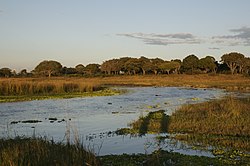
The district covers an area of 14,623 square kilometres (5,646 sq mi). Most of the district is protected forest reserve with 8,920.03 km2 (3,444.04 sq mi) of protected forest. The elevation varies between 1,000 m (3,300 ft) to 2,500 m (8,200 ft). Within the district is much of the Katavi National Park and Ugalla River Forest Reserve which overlaps with the Ugalla River National Park into the Tabora Region. [10] :1-2 [12] [13]

Climate

The districts climate is tropical savanna climate with the Aw Koppen-Geiger system classification. The average temperature is 23 °C (73 °F) with an average rainfall of 1,093 millimetres (43.0 in). [14]

Administrative divisions

Nsimbo has two division, 12 wards, and 59 villages and 272 hamlets. [15] [3] :1

Wards (2016 population) [16] :174

  • Ibindi (6,046)
  • Itenka (18,348)
  • Kanoge (17,954)
  • Kapalala (5,130)
  • Katumba (27,239)
  • Litapunga (35,444)
  • Machimboni (4,621)
  • Mtapenda (5,475)
  • Nsimbo (8,085)
  • Sitalike (10,969)
  • Ugalla (11,352)
  • Urwila (6,970)

Demographics

A Makuti house in Nsimbo Nyumba ya makuti, Katavi Tanzania.jpg
A Makuti house in Nsimbo

In 2016 the Tanzania National Bureau of Statistics report there were 157,633 people in the district, from 144,245 in 2012. Wabende, Wakonongo, Wafipa, Wapimbwe, Bahutu, Wachanga, and Basukuma make up the people. [16] :174 [3] :2 In 2022 the population was 201,102. [17]

Economy

The economy is primarily agriculture. Food crops grown are cassava, maize, paddy, sweet potatoes, round potatoes, bananas, yams, and other fruits and vegetables. Crops grown for money are tobacco, peanuts, sunflowers, sesame, and sugarcane. [18]

There are no large or medium scale industries or mining operations in the district, but locals do small scale mining of gold, copper, silver, lead, tungsten, rose quarts, and nitre. [19]

Health and education

Nsimbo has 3 health centers, and 18 health clinics. There are 47 primary schools, and 8 secondary schools in the district. [15]

Related Research Articles

<span class="mw-page-title-main">Tabora</span> City of Tabora Region in Tanzania

Tabora is the capital of Tanzania's Tabora Region and is classified as a municipality by the Tanzanian government. It is also the administrative seat of Tabora Urban District. According to the 2012 census, the district had a population of 226,999.

<span class="mw-page-title-main">Rukwa Region</span> Region of Tanzania

Rukwa Region(Mkoa wa Rukwa in Swahili) is one of Tanzania's 31 administrative regions The region covers a land area of 27,765 km2 (10,720 sq mi). The region is comparable in size to the combined land area of the nation state of Haiti. Rukwa Region is bordered to the north by Katavi Region, to the east by Songwe Region, to the south by the nation of Zambia and to the west by Lake Tanganyika, which forms a border between Tanzania and the Democratic Republic of the Congo. The regional capital is the municipality of Sumbawanga. According to the 2022 national census, the region had a population of 1,540,519.

<span class="mw-page-title-main">Kigoma Region</span> Region of Tanzania

Kigoma Region is one of Tanzania's 31 administrative regions. The regional capital is the city of Kigoma. Kigoma Region borders Kagera Region, Geita Region, Katavi Region, Tabora Region, DRC and Burundi According to the 2012 national census, the region had a population of 2,127,930, which was higher than the pre-census projection of 1,971,332. For 2002-2012, the region's 2.4 percent average annual population growth rate was tied for the fourteenth highest in the country. It was also the sixteenth most densely populated region with 57 people per square kilometer. With a size of 45,066 square kilometres (17,400 sq mi), the region is slightly smaller than Estonia.

<span class="mw-page-title-main">Tabora Region</span> Region of Tanzania

Tabora Region is one of Tanzania's 31 administrative regions. The regional capital is the municipality of Tabora. The region is located in mid-western part of Tanzania. Tabora is bordered by Shinyanga to the north, Singida to the east, Mbeya and Songwe to the south. lastly, Katavi, Kigoma and Geita, border Tabora to the west. Tabora is by far the largest region in Tanzania by area. Most of the population in the region is concentrated in the north in Nzega district. According to the 2022 national census, Tabora Region had a population of 3,391,679.

<span class="mw-page-title-main">Mpanda District</span> District of Katavi Region, Tanzania

Mpanda District is one of the five districts of the Katavi Region of Tanzania. Its administrative seat is the city of Mpanda. The district is bordered to the northwest by the Kigoma Region, to the northeast by the Tabora Region, to the east by the Mbeya Region, to the southeast by the Sumbawanga Urban District, to the southwest by the Nkasi District and to the west by Lake Tanganyika.

<span class="mw-page-title-main">Manyoni District</span> District in Singida Region, Tanzania

Manyoni District is one of the six districts in the Singida Region of Tanzania. The district capital is the town of Manyoni. The district is bordered to the north by the Ikungi District, to the east by the Dodoma Region, to the south by the Iringa Region, to the southwest by the Mbeya Region and to the west by the Tabora Region. In 2015 the Itigi District was created from the Manyoni District, separating the Itigi Division that was the large portion of the south western of the district.

As of 2021, there are 31 regions of Tanzania which are divided into 184 districts.

<span class="mw-page-title-main">Uvinza</span> District of Kigoma Region, Tanzania

Uvinza is one of the eight administrative districts of Kigoma Region in Tanzania. Uvinza is bordered to the northwest by Kigoma District and Kigoma-Ujiji District. North of the district is bordered by Kasulu District. Lake Tanganyika borders the district on the west. Mpanda District in Katavi Region boders the district to the south and Kaliua District in Tabora Region borders the district to the east. The district is named in honor of the Vinza people whom the western part of district was their historic kingdom. Southern Uvinza District is home to the Mahale Mountains National Park. A unique park that is home to both Chimpanzees and lions in the same habitat.

<span class="mw-page-title-main">Outline of Tanzania</span> Overview of and topical guide to Tanzania

The following outline is provided as an overview of and topical guide to Tanzania:

Mpanda is a city in Katavi Region of Tanzania, East Africa with a postcode number 50100. It is the administrative centre of Katavi Region, Mpanda District and is itself one of the four districts of the region.

<span class="mw-page-title-main">Mlele District</span> District in Katavi Region, Tanzania

Mlele District is one of the five districts of the Katavi Region of Tanzania.

<span class="mw-page-title-main">Katavi Region</span> Region of Tanzania

Katavi Region is one of Tanzania's 31 administrative regions. The region covers an area of 45,843 km2 (17,700 sq mi). The region is comparable in size to the combined land area of the nation state of Estonia. Katavi Region is bordered to the east by Tabora Region. The region is bordered to the south by Rukwa Region and Songwe Region. Lastly, Katavi borders DRC on Lake Tanganyika to the west. The region derives its name from Katavi, the spirit of lake Tanganyika. The regional capital city is Mpanda. According to the 2022 national census, the region had a population of 1,152,958.

Ugalla is a small town and ward in Mlele District of Katavi Region, Tanzania, East Africa. The town is on the left (west) bank of the Mtambo River just before it flows into the Ugalla River, on the edge of the Lujaba Swamp.

<span class="mw-page-title-main">Kaliua District</span> District in Tabora Region, Tanzania

Kaliua District is one of the seven districts of the Tabora Region of Tanzania. It is bordered to the north by Kahama and Ushetu Districts, to the east by Uyui District and Urambo District, to the south by Katavi Region and to the west by Uvinza District and Geita Region. Its administrative seat is the town of Kaliua.

<span class="mw-page-title-main">Songwe Region</span> Region in Lake, Tanzania

Songwe Region is one of Tanzania's 31 administrative regions. The region covers a land area of 27,656 km2 (10,678 sq mi). The region is comparable in size to the combined land area of the nation state of Haiti. Songwe Region borders the countries of Zambia and Malawi to the south: Tunduma is the main entry point into Zambia while Isongole is the main entry point into Malawi. Songwe also borders the Tanzanian regions of Rukwa and Katavi in the west, Tabora in the north, and Mbeya in the east. Lake Rukwa is a major body of water in the western part of the region. The region was created on 29 January 2016 from the western half of Mbeya Region. The regional capital is Vwawa. According to the 2022 national census, the region had a population of 1,344,687.

<span class="mw-page-title-main">Newala Town Council, Mtwara</span> District in Mtwara, Tanzania

Newala Town, is a district level town council in the Mtwara Region in the southern coastal Tanzania. The town is in the south central portion of the Mtwara Region, on the northern bank of the Ruvuma River that is the border between Tanzania and Mozambique. The district was established on the 25th of September, 2015.

<span class="mw-page-title-main">Itigi District</span> District in Singida, Tanzania

Itigi District is a district council in the Singida Region of central Tanzania established in 2015. The district lies in the south-western portion of the Singida Region with 123,515 people and encompasses a large area mostly made up of protected game reserves.

<span class="mw-page-title-main">Msalala District</span> District in Shinyanga, Tanzania

Msalala District is a district council in the Shinyanga Region of Tanzania's lake zone established in 2012. The district lies in the middle of the region just north-east of the town of Kahama.

<span class="mw-page-title-main">Ushetu District</span> District in Shinyanga, Tanzania

Ushetu District is a district council in the Shinyanga Region of Tanzania's lake zone established in 2012. The district lies in west most portion of the region just south and west of the town of Kahama.

<span class="mw-page-title-main">Mpimbwe District</span> District in Katavi, Tanzania

Mpimbwe District is a district council in the Katavi Region of Tanzania's Southern Highlands established in 2012. The district lies in the south of the region on Lake Rukwa.

References

  1. 1 2 "Historia". nsimbodc.go.tz (in Swahili). Nsimbo: Nsimbo District Council. Archived from the original on 12 September 2022. Retrieved 12 September 2022.
  2. 1 2 "Halmashauri ya Wilaya ya Nsimbo". nsimbodc.go.tz (in Swahili). Nsimbo: Nsimbo District Council. Archived from the original on 12 September 2022. Retrieved 12 September 2022.
  3. 1 2 3 "Nsimbo DC Strategic Plan" (PDF). nsimbodc.go.tz. Nsimbo: Nsimbo District. July 2015. Archived (PDF) from the original on 17 June 2022. Retrieved 12 September 2022.
  4. "Katavi Postcodes" (PDF). Tanzania Communications Regulatory Authority. Archived (PDF) from the original on 29 July 2022. Retrieved 11 September 2022.
  5. "Historia". rukwa.go.tz (in Swahili). Rukwa: Rukwa Regional Council. Archived from the original on 15 June 2022. Retrieved 11 September 2022.
  6. "Historia". mpandadc.go.tz (in Swahili). Mpanda: Mpanda District Council]. Archived from the original on 15 June 2022. Retrieved 12 September 2022.
  7. "Historia". mpandamc.go.tz (in Swahili). Mpanda: Mpanda. Archived from the original on 5 April 2022. Retrieved 12 September 2022.
  8. "Historia". katavi.go.tz (in Swahili). Mpanda: Katavi District Council]. Archived from the original on 16 June 2022. Retrieved 12 September 2022.
  9. "Mpango Mkakati". mleledc.go.tz (in Swahili). Mlele: Mlele District Council. Archived from the original on 18 June 2022. Retrieved 11 September 2022.
  10. 1 2 Kiwale, Erasto N. (June 2016). "Mpimbwe District Council Strategic Plan" (PDF). mpimbwedc.go.tz. Mpimbwe District: Mpimbew District Council. Archived (PDF) from the original on 27 June 2022. Retrieved 11 September 2022.
  11. "Tanzania Districts Shapefiles - 2019". nbs.go.tz (in English and Swahili). Dodoma, Tanzania: National Bureau of Statistics (Tanzania). Archived from the original on 9 September 2022. Retrieved 11 September 2022.
  12. "Katavi National Park". tanzaniaparks.go.tz (in English and Swahili). Dodoma, Tanzania: Tanzania National Parks Authority. Archived from the original on 7 July 2022. Retrieved 11 September 2022.
  13. "Ugalla River Forest Reserve, Katavi Region, Tanzania". mindat.org. Archived from the original on 12 September 2022. Retrieved 12 September 2022.
  14. "Climate Uruwira (Tanzania)". climate-data.org (in English and German). Germany: Climate-data. Archived from the original on 12 September 2022. Retrieved 12 September 2022.
  15. 1 2 "Takwimu". nsimbodc.go.tz (in Swahili). Nsimbo: Nsimbo District Council. Archived from the original on 17 June 2022. Retrieved 12 September 2022.
  16. 1 2 2016 Makadirio ya Idadi ya Watu katika Majimbo ya Uchaguzi kwa Mwaka 2016, Tanzania Bara [Population Estimates in Administrative Areas for the Year 2016, Mainland Tanzania](PDF) (Report) (in Swahili). Dar es Salaam, Tanzania: National Bureau of Statistics. 1 April 2016. Archived (PDF) from the original on 27 December 2021. Retrieved 11 September 2022.
  17. "Katavi (Region, Tanzania) - Population Statistics, Charts, Map and Location". www.citypopulation.de. Retrieved 9 February 2024.
  18. "Kilimo". nsimbodc.go.tz (in Swahili). Nsimbo: Nsimbo District Council. Archived from the original on 12 September 2022. Retrieved 12 September 2022.
  19. "Uchimbaji Madini". nsimbodc.go.tz (in Swahili). Nsimbo: Nsimbo District Council. Archived from the original on 12 September 2022. Retrieved 12 September 2022.