Crow Agency is a census-designated place (CDP) in Big Horn County, Montana, United States and is near the actual location for the Little Bighorn National Monument and re-enactment produced by the Real Bird family known as Battle of the Little Bighorn Reenactment. The population was 1,616 at the 2010 census. It is the governmental headquarters of the Crow Nation Native Americans. It is also the location of the "agency offices" where the federal Superintendent of the Crow Indian Reservation and his staff interacts with the Crow Tribe, pursuant to federal treaties and statutes.

Belt is a town in Cascade County, Montana, United States. The population was 510 according to the 2020 census. It is part of the Great Falls, Montana metropolitan area.

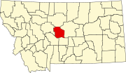
Stanford is a town in and the county seat of Judith Basin County, Montana, United States. The population was at 403 as of the 2020 census.

Copper Harbor is an unincorporated community and census-designated place (CDP) located in Keweenaw County in the U.S. state of Michigan. It is located within Grant Township. The population of the CDP was 136 as of the 2020 census.
Oro Grande is an unincorporated community in the Mojave Desert of San Bernardino County, California, United States. It lies on the city boundary of Victorville and Adelanto. It is at 3,000 feet (910 m) elevation in Victor Valley north of the San Bernardino mountain range. It is located on old Route 66 near Interstate 15 between Victorville and Barstow. The ZIP code is 92368 and the community is inside area codes 442 and 760. Less than 1,000 residents live in the unincorporated area.

Raynesford is an unincorporated community in Judith Basin County, Montana, United States. The community includes a community center, a catholic church, a fire department, and a post office. The post office was established under the name of "Spion Kop" on March 31, 1906; its name was changed to Raynesford exactly three years later.
Condon is an unincorporated community and census-designated place in Missoula County, Montana, United States. Located along the Swan River and Montana Highway 83, Condon is situated between the Swan Range to the east and the Mission Mountains to the west, providing ready access to the Bob Marshall Wilderness and Mission Mountains Wilderness, respectively. Its population was 285 as of the 2020 United States census, down from 343 in 2010.
Jackson is an unincorporated community in Beaverhead County, Montana, United States. Jackson has a post office with a ZIP code 59736. As of the 2020 census, Jackson had a population of 36.

Skyforest is an unincorporated community in San Bernardino County, California, United States.
Wolf Creek is an unincorporated community in Lewis and Clark County, Montana, United States, along Interstate 15, 28 miles (45 km) north of Helena. Its ZIP code is 59648.
Buffalo is an unincorporated rural hamlet in Fergus County, Montana, United States. Buffalo has a church, a post office serving ZIP code 59418, no other businesses or services, and only perhaps half a dozen homes. It was named for the buffalo which roamed this area.
Coffee Creek is an unincorporated community in Fergus County, Montana, United States. It is located along Montana Highway 81 in west central Fergus County, several miles northwest of Denton. Coffee Creek has a post office with the ZIP code 59424.
Acton is an Census Designated Place in northwestern Yellowstone County, Montana, United States. It has a postal ZIP code (59002) and lies along Montana Highway 3 northwest of the city of Billings, the county seat of Yellowstone County.
Geyser is a small, unincorporated rural village in Judith Basin County, Montana, United States, southeast of Great Falls along U.S. Route 87.
Zurich is an unincorporated community in Blaine County, Montana, United States. Located along the Hi-Line of Montana, between Harlem and Chinook, along U.S. Route 2. It has a post office with the ZIP code of 59547, and a public school serving grades PK through 8. There is also a bar; the store and bank are closed and abandoned, as are two grain elevators and other business buildings. Various online sources give the population as 22-23 residents.
Zortman is a census-designated place and unincorporated community in Phillips County, Montana, United States. Its population was 69 as of the 2010 census. Zortman has a post office with ZIP code 59546.

Hinsdale is an unincorporated community and census-designated place in Valley County, Montana, United States. The town's population was 217 and the community's population as a whole was 583 as of the 2010 census. The community is located on the Milk River and U.S. Route 2, with Montana Highway 537 headed north out of town and South Bench Road crossing the railroad tracks and running south of town. Hinsdale has a post office with ZIP code 59241.
Brady is a census-designated place and unincorporated community in Pondera County, Montana, United States. Its population was 140 as of the 2010 census. Brady has a post office with ZIP code 59416. The community is located along Interstate 15.
Kila is a census-designated place and unincorporated community in Flathead County, Montana, United States. Its population was 424 as of the 2020 census. Kila has a post office with ZIP code 59920, which opened on May 27, 1901. The community is located along U.S. Route 2, 10 miles from Kalispell.
Homestead is an unincorporated community in Sheridan County, Montana, United States. Homestead is located along a railroad, 5.8 miles (9.3 km) south-southwest of Medicine Lake. The community had a post office until November 19, 1994; it still has its own ZIP code, 59242.