Sapphire Ridge, Montana

Last updated

Sapphire Ridge, Montana
USA Montana location map.svg
Red pog.svg
Sapphire Ridge
Usa edcp location map.svg
Red pog.svg
Sapphire Ridge
Coordinates: 46°53′12″N110°15′9″W / 46.88667°N 110.25250°W / 46.88667; -110.25250
CountryUnited States
State Montana
County Judith Basin
Area
[1]
  Total0.54 sq mi (1.40 km2)
  Land0.54 sq mi (1.40 km2)
  Water0.00 sq mi (0.00 km2)
Elevation
[2]
4,894 ft (1,492 m)
Population
 (2020)
  Total26
  Density48.15/sq mi (18.58/km2)
Time zone UTC-7 (Mountain (MST))
  Summer (DST) UTC-6 (MDT)
ZIP Code
59452 (Hobson)
Area code 406
FIPS code 30-66317
GNIS feature ID2806632 [2]

Sapphire Ridge is a census-designated place (CDP) in Judith Basin County, Montana, United States. The community is more commonly known as Sapphire Village. [3] [4] It is in the southern part of the county, on the west side of the valley of the Judith River, a northeast-flowing tributary of the Missouri River.

Contents

Pigeye Road is the main route out of the community, leading northeast 10 miles (16 km) down the Judith River valley to Utica. To the southwest the road leads into the Little Belt Mountains and Lewis and Clark National Forest.

Sapphire Ridge was first listed as a CDP prior to the 2020 census. [2]

Demographics

Historical population
CensusPop.Note
2020 26
U.S. Decennial Census [5]

Climate

Lewistown 42 WSW is a weather station located near Sapphire Village. [6] Lewistown 42 WSW has a humid continental climate (Köppen Dfb), bordering on a subalpine climate (Köppen Dfc).

Climate data for Lewistown 42 WSW, Montana, 1991–2020 normals, 2008-2023 extremes: 5070ft (1545m)
MonthJanFebMarAprMayJunJulAugSepOctNovDecYear
Record high °F (°C)67
(19)
65
(18)
70
(21)
80
(27)
82
(28)
95
(35)
95
(35)
96
(36)
96
(36)
85
(29)
71
(22)
64
(18)
96
(36)
Mean maximum °F (°C)54.0
(12.2)
52.6
(11.4)
61.2
(16.2)
71.1
(21.7)
76.4
(24.7)
85.0
(29.4)
89.8
(32.1)
91.1
(32.8)
86.9
(30.5)
75.3
(24.1)
63.5
(17.5)
53.6
(12.0)
92.2
(33.4)
Mean daily maximum °F (°C)36.5
(2.5)
35.8
(2.1)
43.5
(6.4)
49.8
(9.9)
59.5
(15.3)
67.4
(19.7)
77.5
(25.3)
77.3
(25.2)
68.5
(20.3)
53.3
(11.8)
42.1
(5.6)
34.7
(1.5)
53.8
(12.1)
Daily mean °F (°C)24.9
(−3.9)
24.0
(−4.4)
31.5
(−0.3)
37.3
(2.9)
46.3
(7.9)
53.7
(12.1)
60.9
(16.1)
60.6
(15.9)
52.2
(11.2)
40.6
(4.8)
31.2
(−0.4)
24.0
(−4.4)
40.6
(4.8)
Mean daily minimum °F (°C)13.3
(−10.4)
12.1
(−11.1)
19.6
(−6.9)
24.7
(−4.1)
33.0
(0.6)
40.0
(4.4)
44.3
(6.8)
43.8
(6.6)
36.0
(2.2)
27.8
(−2.3)
20.4
(−6.4)
13.3
(−10.4)
27.4
(−2.6)
Mean minimum °F (°C)−18.7
(−28.2)
−19.3
(−28.5)
−7.3
(−21.8)
6.8
(−14.0)
18.5
(−7.5)
29.5
(−1.4)
34.6
(1.4)
31.9
(−0.1)
22.9
(−5.1)
5.8
(−14.6)
−5.9
(−21.1)
−18.0
(−27.8)
−28.8
(−33.8)
Record low °F (°C)−32
(−36)
−39
(−39)
−39
(−39)
−9
(−23)
10
(−12)
24
(−4)
30
(−1)
23
(−5)
8
(−13)
−15
(−26)
−21
(−29)
−41
(−41)
−41
(−41)
Average precipitation inches (mm)0.61
(15)
0.82
(21)
0.86
(22)
1.60
(41)
2.83
(72)
3.07
(78)
1.70
(43)
1.40
(36)
1.34
(34)
1.33
(34)
0.65
(17)
0.55
(14)
16.76
(427)
Average precipitation days (≥ 0.01 in)8.510.39.513.315.212.39.49.07.18.87.79.3120.4
Source 1: NOAA [7]
Source 2: XMACIS2 (temp records & 2008-2023 monthly max/mins) [8]

Related Research Articles

<span class="mw-page-title-main">Evergreen, Montana</span> Unincorporated community in Montana, United States

Evergreen is a census-designated place (CDP) in Flathead County, Montana, United States. Its population was 8,149 at the 2020 census, up from 7,616 at the 2010 census, and 6,215 in 2000.

<span class="mw-page-title-main">Amanda Park, Washington</span> Census-designated place in Washington, United States

Amanda Park is a census designated place on the Olympic Peninsula in Grays Harbor County, Washington, United States, along U.S. Route 101. Olympic National Park and Lake Quinault are directly to the north. As of the 2010 census the population was 252.

<span class="mw-page-title-main">Dell, Montana</span> Census-designated place in Montana, United States

Dell is a census-designated place in Beaverhead County, Montana, United States. The settlement is located in a valley beside the Red Rock River.

<span class="mw-page-title-main">Cooke City, Montana</span> Census-designated place in Montana, United States

Cooke City is an unincorporated community and census-designated place (CDP) in Park County, Montana, United States. As of the 2020 census, it had a population of 77. Prior to 2010, it was part of the Cooke City-Silver Gate CDP.

Silver Gate is an unincorporated community and census-designated place (CDP) in Park County, Montana, United States. As of the 2010 census, it had a population of 20. Prior to 2010, it was part of the Cooke City-Silver Gate CDP.

<span class="mw-page-title-main">Big Snowy Mountains</span> Mountain range in Montana, United States

The Big Snowy Mountains are a small mountain range south of Lewistown in Fergus County, Montana. Considerably east of and isolated from the main crest of the Northern Rockies, they are one of the few points of significant elevation in the immediate area and are considered one of Montana's island ranges. The range's highest elevation is 8,681 feet (2,646 m). The smaller Little Snowy Mountains are a contiguous range immediately to the east.

Savage is an unincorporated community and census-designated place (CDP) in Richland County, Montana, United States. Savage is located on the Yellowstone River and Montana Highway 16, 20 miles (32 km) south-southwest of Sidney.

<span class="mw-page-title-main">Roy, Montana</span> Census-Designated Place in Montana, United States

Roy is a census-designated place (CDP) in Fergus County, Montana, United States.

<span class="mw-page-title-main">Upper Bear Creek, Colorado</span> Census Designated Place in Colorado, United States

Upper Bear Creek is an unincorporated community and a census-designated place (CDP) located in and governed by Clear Creek County, Colorado, United States. The CDP is a part of the Denver–Aurora–Lakewood, CO Metropolitan Statistical Area. The population of the Upper Bear Creek CDP was 984 at the United States Census 2020. The Evergreen post office serves the area.

Geyser is a small, unincorporated rural village in Judith Basin County, Montana, United States, southeast of Great Falls along U.S. Route 87.

Conner is a census-designated place (CDP) in Ravalli County, Montana, United States. The population was 216 at the 2010 census.

Ayers Ranch Colony is a Hutterite community and census-designated place (CDP) in Fergus County, Montana, United States. It is in the southeastern part of the county, on the north side of U.S. Route 87/Montana Highway 200, 8 miles (13 km) west of Grass Range and 24 miles (39 km) east of Lewistown. The North Fork of McDonald Creek runs through the community, part of the Musselshell River watershed leading to the Missouri River.

Fords Creek Colony is a Hutterite community and census-designated place (CDP) in Fergus County, Montana, United States. It is in the eastern part of the county, 12 miles (19 km) northwest of Grass Range and 29 miles (47 km) northeast of Lewistown.

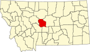
Spring Creek Colony is a Hutterite community and census-designated place (CDP) in Fergus County, Montana, United States. It is in the western part of the county, along Big Spring Creek, a northwest-flowing tributary of the Judith River, which in turn flows north to the Missouri River. The colony sits at the western foot of the South Moccasin Mountains and is 14 miles (23 km) northwest of Lewistown, the Fergus county seat.

Warm Spring Creek is an unincorporated community and census-designated place (CDP) in Fergus County, Montana, United States. It is near the geographic center of the county, on the west side of the Judith Mountains, in the valley of Warm Spring Creek, a west-flowing tributary of the Judith River. The community sits along Maiden Road, 16 miles (26 km) northeast of Lewistown, the county seat.

Surprise Creek Colony is a Hutterite community and census-designated place (CDP) in Judith Basin County, Montana, United States. It is in the north-central part of the county, in the valley of Surprise Creek, a north-flowing tributary of Arrow Creek, which continues northeast to the Missouri River.

Windham is a census-designated place (CDP) in Judith Basin County, Montana, United States. It is in the center of the county along U.S. Route 87, Montana Highway 200 and 3. The town is 6 miles (10 km) southeast of Stanford, the county seat, and 38 miles (61 km) west of Lewistown.

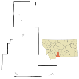
Potomac is an unincorporated community and census-designated place (CDP) in Missoula County, Montana, United States. It is in the southeastern part of the county, in the valley of Camas Creek and Union Creek, which flows northwest to the Blackfoot River, part of the Clark Fork watershed.

Gila Hot Springs is an unincorporated community and census-designated place (CDP) in Grant County, New Mexico, United States. It was first listed as a CDP prior to the 2020 census.

South Lincoln is a census-designated place (CDP) within the town of Lincoln, Addison County, Vermont, United States. It was first listed as a CDP prior to the 2020 census.

References

  1. "ArcGIS REST Services Directory". United States Census Bureau. Retrieved September 5, 2022.
  2. 1 2 3 "Sapphire Ridge Census Designated Place". Geographic Names Information System . United States Geological Survey, United States Department of the Interior.
  3. "Sapphire Village, Montana". RussellCountry.com. Retrieved June 10, 2021.
  4. "Sapphire Village". Geographic Names Information System . United States Geological Survey, United States Department of the Interior.
  5. "Census of Population and Housing". Census.gov. Retrieved June 4, 2016.
  6. "Data of Meteorological Station Lewistown 42 Wsw, Montana". geographic.org. Retrieved January 11, 2024.
  7. "Lewistown 42 WSW, Montana 1991-2020 Monthly Normals" . Retrieved January 11, 2024.
  8. "xmACIS". National Oceanic and Atmospheric Administration. Retrieved January 11, 2024.