
Nuytsland Nature Reserve is a protected area of Western Australia in the south-eastern part of the state, on the south coast.
The Nallian Nature Reserve is located approximately fifteen kilometres north east of Wagin, Western Australia.

The Drummond Nature Reserve is an A class nature reserve 10 kilometres west of Bolgart, Western Australia. Named after the botanist James Drummond, the reserve has 439 species of vascular plants within its boundaries, including two rare and seven priority species.

Lake Magenta Nature Reserve is a 1080 km2 nature reserve managed by the Department of Parks and Wildlife, making it one of the largest such reserves in the Western Mallee bioregion of Western Australia. It is named after Lake Magenta, which lies just within its eastern boundary.
Badjaling Nature Reserve is a nature reserve managed by the Department of Parks and Wildlife, located at Badjaling in the Wheatbelt region of Western Australia. Located east of Quairading, it is a reserve of native bushland, surrounded by land long since cleared for agriculture.
Burma Road Nature Reserve is a conservation area in the City of Greater Geraldton local government area of Western Australia. It lies 52 kilometres (32 mi) south of Geraldton and 20 kilometres (12 mi) east of Walkaway. It is a C-class reserve and covers an area of 6,889.5 hectares It is predominantly kwongan scrub-heath, typical of the Tathra Vegetation system of Beard and Burns. Almost all the native vegetation within a 20 km (12 mi) radius of the reserve has been cleared. There is only 11% of native vegetation remaining in the area, of which most is within the reserve.
Mount Manning Range Nature Reserve is a nature reserve in the Goldfields region of Western Australia north of Southern Cross in the area known as the Northern Yilgarn, in the Coolgardie bioregion. It originally covered an area of 170,000 hectares, but, as of 2022, its size stands at 36,607 hectares.
Dragon Rocks is a 322 km2 nature reserve in the south-east of the wheatbelt region of Western Australia, some 310 km east-south-east of Perth. It is surrounded by farmland. It is listed on Australia's Register of the National Estate as an area significant for rare species of plants and animals.

The Karroun Hill Nature Reserve is a 3097 km2 nature reserve in the Mid West region of Western Australia, about 310 km north-east of Perth.
Dragon Tree Soak Nature Reserve is located in the Great Sandy Desert in the southern part of the Kimberley region of Western Australia.
Moondyne Nature Reserve is a reserve located within the Avon Valley National Park, in the Avon Valley, Western Australia.
Queen Victoria Spring Nature Reserve is a protected area managed by the Department of Parks and Wildlife and is located approximately 200 km (124 mi) east of Kalgoorlie in the Great Victoria Desert in the Goldfields-Esperance region of Western Australia.
Down Road Nature Reserve is a protected area of Western Australia in the south-western part of the state. It is located approximately 14 km (8.7 mi) northwest of Albany. It has existed since 1932 and covers an area of approximately 7.78 square kilometers.
Greater Kingston National Park is a national park in the South West region of Western Australia, 308 km (191 mi) south of Perth. It is located in the Shires of Bridgetown–Greenbushes, Boyup Brook and Manjimup. It is located in the Jarrah Forest bioregion.
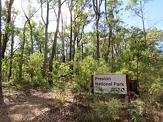
Greater Preston National Park, sometimes referred to as just Preston National Park, is a national park in the South West region of Western Australia, 222 km (138 mi) south of Perth. It is predominantly located in the Shire of Boyup Brook and Shire of Donnybrook–Balingup, with the north-eastern corner of the national park also reaching into the Shire of Collie and Shire of West Arthur. It is located in the Jarrah Forest bioregion.
Hilliger National Park is a national park in the South West region of Western Australia, 304 km (189 mi) south of Perth. It is located in the Shire of Nannup, with the Milyeannup National Park bordering to the north and the Easter National Park to the east. The park is located in the Jarrah Forest and Warren bioregions.
Wiltshire-Butler National Park is a national park in the South West region of Western Australia, 265 km (165 mi) south of Perth. It is located in the Shire of Nannup, bordering the Blackwood River National Park. The park is located in the Jarrah Forest bioregion.
Helena and Aurora Ranges National Park, located in the Helena and Aurora Range, is a proposed national park in the Goldfields–Esperance and Wheatbelt regions of Western Australia, 440 km (270 mi) east of Perth. The proposed national park, with an initial size of 149,157 hectares, subsequently extended to 333,127 hectares, is located in the Shires of Menzies and Yilgarn and is part of the Coolgardie bioregion.

