
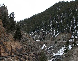
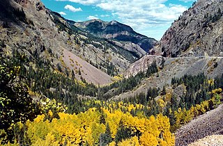
The Mohave Canyon is located on the Colorado River, south of Needles, California. [1] It is part of Topock Gorge, a mountainous canyon and gorge section of the Colorado River located between Interstate 40 and Lake Havasu.
The Mohave Canyon is located on the Colorado River, south of Needles, California. [1] It is part of Topock Gorge, a mountainous canyon and gorge section of the Colorado River located between Interstate 40 and Lake Havasu.

A canyon, or gorge, is a deep cleft between escarpments or cliffs resulting from weathering and the erosive activity of a river over geologic time scales. Rivers have a natural tendency to cut through underlying surfaces, eventually wearing away rock layers as sediments are removed downstream. A river bed will gradually reach a baseline elevation, which is the same elevation as the body of water into which the river drains. The processes of weathering and erosion will form canyons when the river's headwaters and estuary are at significantly different elevations, particularly through regions where softer rock layers are intermingled with harder layers more resistant to weathering.

The Royal Gorge is a canyon of the Arkansas River located west of Cañon City, Colorado. The canyon begins at the mouth of Grape Creek, about 2 mi (3.2 km) west of central Cañon City, and continues in a west-northwesterly direction for approximately 6 mi (9.7 km) until ending near U.S. Route 50. Being one of the deepest canyons in Colorado, it is also known as the Grand Canyon of the Arkansas (River), with a maximum depth of 1,250 ft (380 m). The canyon is also very narrow, measuring from 50 ft (15 m) wide at its base to 300 ft (91 m) wide at its top, as it carves a path through the granite formations below Fremont Peak and YMCA Mountain, which rise above the north and south rims, respectively.

The Mohave Valley is a valley located mostly on the east shore of the south-flowing Colorado River in northwest Arizona. The valley extends into California's San Bernardino County; the northern side of the valley extends into extreme southeast Clark County, Nevada. The main part of the valley lies in southwest Mohave County, Arizona and is at the intersection of the southeast Mojave and northwest Sonoran deserts.

The Platte Canyon is a deep, narrow, scenic gorge on the South Platte River in the Rocky Mountains of Colorado. The canyon is southwest of Denver on the border between Jefferson and Douglas counties. The canyon is at the entrance to the mountains, where the South Platte emerges through the Rampart Range through the hogbacks onto Eastern Plains. The lower narrow section is sometimes called Waterton Canyon, referring to Waterton, Colorado.

Gore Canyon, elevation 6,985 feet (2,129 m), is a short isolated canyon on the upper Colorado River in southwestern Grand County, Colorado in the United States. Steep and rugged, the approximately 3 mile (5 km) long gorge was carved by the river as it passed the northern end of the Gore Range southwest of Kremmling. The Colorado descends from approximately 7,300 ft (2,200 m) to approximately 7,000 ft (2,100 m) over the length of the canyon. The steep walls ascend approximately 1,000 ft (300 m) on either side. The canyon effectively marks the southwestern end of the Middle Park basin in north central Colorado.
Byers Canyon is a short gorge on the upper Colorado River in Grand County, Colorado in the United States. The canyon is approximately 8 miles (13 km) long and is located in the headwaters region of the Colorado between Hot Sulphur Springs and Kremmling. U.S. Highway 40 passes through the canyon between Hot Sulphur Springs and Kremmling. The Union Pacific Railroad's Moffat Route also travels through the short canyon.

Cimarron is an unincorporated rural hamlet in Montrose County, Colorado, United States. It is located on the northern side of U.S. Highway 50, 19 miles from the town of Montrose to its west, and 42 miles from Gunnison, Colorado Gunnison to its east. There is a store with fuel pumps and a post office at Cimarron. The post office services the rural ZIP Code 81220 area.

Westwater Canyon is a canyon located on the Colorado River in Eastern Utah between the Utah/Colorado state line and Cisco, Utah. The inner gorge of the canyon is made up of black Precambrian rock and contains class III and IV rapids which are sought after by whitewater enthusiasts. The most notable rapid, called "Skull", is the most significant.
The Uncompahgre Gorge is a deep mountain canyon formed by the Uncompahgre River and Red Mountain Creek in the San Juan National Forest. It is located just south of Ouray, in Ouray County, Colorado.

The Tonto Trail is a hiking trail on the South Rim of the Grand Canyon in Grand Canyon National Park, located in the U.S. state of Arizona.

The Mojave Road, also known as Old Government Road, is a historic route and present day dirt road across what is now the Mojave National Preserve in the Mojave Desert in the United States. This rough road stretched 147 miles (237 km) from Beale's Crossing, to Fork of the Road location along the north bank of the Mojave River where the old Mojave Road split off from the route of the Old Spanish Trail/Mormon Road.

The Colorado River Storage Project is a United States Bureau of Reclamation project designed to oversee the development of the upper Colorado River basin. The project provides hydroelectric power, flood control and water storage for participating states along the upper portion of the Colorado River and its major tributaries.

Bright Angel Creek is an American body of water located at the bottom of the Grand Canyon National Park flowing into the Colorado River at the end of the North Kaibab Trail on the north side of the river. The creek originates from Roaring Springs that emerge from a cliff along the North Kaibab Trail and drains to the Colorado. The North Kaibab Trail largely follows the creek, including through "the Box," a narrow, high-walled part of the trail that becomes extremely hot in daylight during the summer months.
El Dorado City, which is now a ghost town, was a mining camp in the Colorado Mining District at the mouth of January Wash at its confluence with El Dorado Canyon. It was located about a mile down the canyon from Huse Spring, at an elevation of 2382 feet. Its site was located nearby to the south southeast of the Techatticup Mine the primary source of the ore its mill processed.
Colorado City is now a ghost town, in Clark County, Nevada, located under Lake Mohave at the mouth of El Dorado Canyon.

Boulder Canyon, originally Devils Gate Canyon, is a canyon on the Colorado River, above Hoover Dam, now flooded by Lake Mead. It lies between Clark County, Nevada and Mohave County, Arizona. It heads at western end of the Virgin River Basin of Lake Mead, at about 36°09′05″N114°32′51″W. Boulder Canyon divides the Black Mountains into the Black Mountains of Arizona, and the Black Mountains of Nevada. Its mouth is now under the eastern end of the Boulder Basin of Lake Mead, between Canyon Point in Nevada and Canyon Ridge in Arizona. Its original mouth is now underneath Lake Mead between Beacon Rock and Fortification Ridge on the southern shore in Arizona.
Eureka or Eureka Landing, is a former mining town and steamboat landing, now a ghost town, on the Arizona bank of the Colorado River in what is now La Paz County, Arizona. It was originally located in Yuma County, Arizona from 1863 through the 1870s.

The Needles are a distinctive group of rock pinnacles, mountain peaks adjacent to the Topock Gorge, and the Colorado River on the northwestern extreme of the Mohave Mountains within the Havasu National Wildlife Refuge in Mohave County, Arizona, United States. They range from 1207 to over 1600 feet in altitude.
Callville Wash is an ephemeral stream or wash in Clark County, Nevada. It was named for Callville the riverport settlement founded in 1866, at its mouth where it had its original confluence with the Colorado River.
Boulder Wash is an ephemeral stream or wash in Clark County, Nevada. Its mouth is at its confluence with the Boulder Wash Cove of Lake Mead at an elevation 1,276 feet / 389 meters at when Lake Mead is at its full level. Currently as the reservoir is at a much lower level its mouth is found at approximately 36°10′07″N114°33′07″W. Its source is at 36°13′36″N114°31′22″W at an elevation of 2,841 feet / 866 meters in the Black Mountains. It flows down a canyon into the upper Pinto Valley southwestward before turning southeastward to Boulder Wash Cove.
Coordinates: 34°38′56″N114°26′49″W / 34.649°N 114.447°W
| | This San Bernardino County, California–related article is a stub. You can help Wikipedia by expanding it. |