Related Research Articles

Greater Binghamton Airport is a county-owned American airport eight miles north of Binghamton, in Broome County, New York. It is in East Maine, New York and serves the Southern Tier of New York.

Elmira Corning Regional Airport is in Chemung County, New York, seven miles northwest of Elmira and eight miles east of Corning. It is in the town of Big Flats but its mailing address is Horseheads, New York. The airport was formerly Elmira Regional Airport.
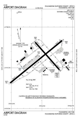
Hudson Valley Regional Airport, formerly known as Dutchess County Airport, is a county-owned public-use airport located on State Route 376 in the Town of Wappinger, Dutchess County, New York, United States, four miles (6 km) south of the central business district of Poughkeepsie. It is sometimes called Poughkeepsie Airport, which gives it the code POU. The airport provides corporate and general aviation transportation services.
Massena International Airport is in St. Lawrence County, New York. It is two nautical miles (3.7 km) east of the village of Massena. The airport sees one airline, subsidized by the Essential Air Service program.
Ogdensburg International Airport is a public airport located in the town of Oswegatchie, 2 miles (3.2 km) southeast of Ogdensburg, in St. Lawrence County, New York. It is owned by the Ogdensburg Bridge & Port Authority, which also owns and operates the Ogdensburg–Prescott International Bridge, Port of Ogdensburg-Marine Terminal Facility, Commerce Park, Port of Waddington, a medium-heavy industrial park and two short line railroads. The Ogdensburg Bridge and Port Authority is a New York State public-benefit corporation. The international airport is just outside the city limits on NY 812. It is used for general aviation and commercial service. Scheduled commercial flights are operated by one airline: Contour Airlines.

Floyd Bennett Memorial Airport is a county-owned, public-use airport in Warren County, New York, United States. It is located three nautical miles (6 km) northeast of the central business district of Glens Falls, in the town of Queensbury. This airport is included in the National Plan of Integrated Airport Systems for 2011–2015, which categorized it as a general aviation facility.
Pittsfield Municipal Airport is two miles west of Pittsfield, in Berkshire County, Massachusetts. The National Plan of Integrated Airport Systems for 2011–2015 categorized it as a general aviation facility.

Skagway Airport is a state-owned public-use airport in the city of Skagway, Alaska.
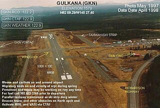
Gulkana Airport is a state owned, public use airport located four nautical miles northeast of the central business district of Gulkana, in the Valdez-Cordova Census Area of the U.S. state of Alaska. It is also and five miles (8 km) northeast of Glenallen. Scheduled passenger service is subsidized by the Essential Air Service program.
May Creek Airport is a state owned, public use airport located one nautical mile (2 km) south of the central business district of May Creek, in the Valdez-Cordova Census Area of the U.S. state of Alaska. Scheduled passenger service is subsidized by the Essential Air Service program.
Oneonta Municipal Airport is a public use airport located three nautical miles north of the central business district of Oneonta, a city in Otsego County, New York, United States. The airport is owned by the City of Oneonta. It once had scheduled air service on Mohawk Airlines, formerly known as Catskill Airways.
St. George Airport is a state-owned public-use airport located four nautical miles of the central business district of St. George, a city on St. George Island in the Aleutians West Census Area of the U.S. state of Alaska. Scheduled passenger airline service is provided by Grant Aviation.
Hendricks Field is a private use airport located three nautical miles (6 km) northeast of Gouverneur, a village in the Town of Gouverneur, St. Lawrence County, New York, United States. It was formerly a public use airport at which time its FAA location identifier was 1K0.
Randall Airport is a public use airport in Orange County, New York, United States. It is owned by Aerodrome Dev Corp and is located two nautical miles southeast of the central business district of the City of Middletown. According to the FAA's National Plan of Integrated Airport Systems for 2007-2011, it is categorized as a reliever airport.

Naknek Airport is a state-owned, public-use airport located one nautical mile north of the central business district of Naknek, in the Bristol Bay Borough of the U.S. state of Alaska.
Granville Airport is a public use airport in Washington County, New York, United States. It is located one nautical mile (1.85 km) north of the central business district of Granville, a village in the Town of Granville.
Luther Airport is a private use airport located one nautical mile east of the central business district of Chittenango, a village in the Town of Sullivan in Madison County, New York, United States.
Blue Heron Airport is a privately owned, public use airport in Schoharie County, New York, United States. It is three nautical miles (6 km) northeast of the central business district of Gallupville, New York. It was formerly a private-use facility with the FAA identifier NK93.
Cattaraugus County-Olean Airport is a city-owned, public-use airport located 10 nautical miles north of the central business district of Olean, a city in Cattaraugus County, New York, United States. It is included in the National Plan of Integrated Airport Systems for 2011–2015, which categorized it as a general aviation facility.
Syracuse Hancock International Airport is a joint civil–military airport five miles (8 km) northeast of downtown Syracuse, New York, and 65 miles (100 km) south of Watertown. Operated by the Syracuse Department of Aviation, it is located off Interstate 81, near Mattydale. The main terminal complex is at the east end of Colonel Eileen Collins Boulevard. Half of the airport is located within the Town of DeWitt, with portions in the towns of Salina and Cicero.
References
- 1 2 3 "FAA Airport Master Record" (PDF). Federal Aviation Administration. 7 May 2009.
- ↑ "Mohawk Valley Airpark (31NK)" (PDF). New York State Department of Transportation.